

Translate this page into:
Understanding the impact of deep structures on the hydrological setting of the Eastern Bahira Basin in Morocco using combined geophysical analysis of gravity, seismic, and electrical resistivity data
⁎Corresponding author. anas.charbaoui@um6p.ma (Anas Charbaoui)
-
Received: ,
Accepted: ,
This article was originally published by Elsevier and was migrated to Scientific Scholar after the change of Publisher.
Abstract
In arid regions like the Eastern Bahira Basin, communities mainly rely on groundwater for drinking and irrigation. However, efficiently managing these vital resources requires a deep understanding of the underlying aquifers’ structure and identifying the most suitable areas for exploitation. This presents a significant challenge for the success of water supply and irrigation programs in the Eastern Bahira Basin. This study is based on an integrative approach, combining Electrical Resistivity Tomography data, with the compilation and reinterpretation of pre-existing seismic, gravimetric and vertical electrical sounding data. This approach is based on compiling old gravimetric data and applying advanced processing techniques to determine the horizontal gradient maxima, which helps highlight the major structural alignments in the basin. Furthermore, the approach utilizes seismic data in order to enhance understanding of the deep structure of the basin, reinterpreting it in light of recent drilling data. The interpretation of the gravimetric and seismic data has also been validated by the results of vertical electrical soundings and electrical tomography that we recently acquired in the Eastern Bahira basin. The outcomes of this research provide new insights into the deep structure of the Eastern Bahira Basin and suggest the most promising hydrogeological prospects, thereby contributing to the success of the ongoing drinking water supply and irrigation program in the Eastern Bahira Basin.
Keywords
Groundwater aquifer
Deep structure
Gravimetry
Seismic
Electrical resistivity tomography
Eastern Bahira Basin
Morocco

1 Introduction
The management of groundwater resources in Morocco is a major challenge, particularly due to the scarcity of rainfall associated with the arid and semi-arid climate. In this context, the exploitation of groundwater aquifers becomes a necessity and requires a deep understanding of their distribution and hydrodynamic functioning. The Eastern Bahira Basin (EBB), located in central Morocco (Fig. 1), is one such region where groundwater plays a crucial role in providing drinking water and supporting the agricultural activities of local communities. In this basin, annual rainfall rarely exceeds 200 mm, and potential evaporation is estimated to exceed 1000 mm (Karroum, 2015). Over the last decade, a significant decrease in the piezometric levels of the groundwater aquifers has been observed in this basin, accompanied by an increase in water salinity in the shallower aquifers (El Mokhtar et al., 2012; Karroum et al., 2017).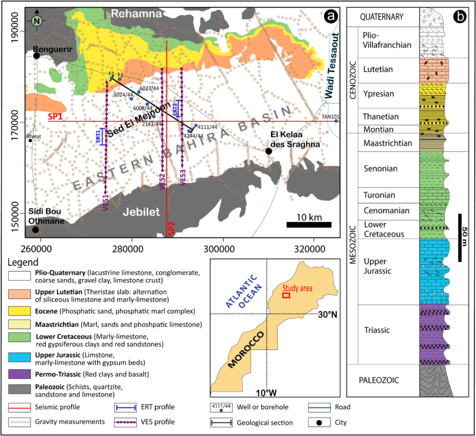
(a) Simplified geological map and location of the geophysical and borehole data used in this study; (b) synthetic stratigraphic log of the Eastern Bahira Basin (compiled and modified from Michard, 1976 & Boujo, 1976).
Previous studies have investigated the geometry of the sedimentary cover and the hydrogeological functioning of the aquifer system in the western and central parts of the Bahira Basin (e.g. Khalil, 1989; Er-rouane, 1996; El Mokhtar et al., 2012; Karroum et al., 2014, 2017; Elgettafi et al., 2016; Jaffal et al., 2022; Lghoul et al., 2023; Charbaoui et al., 2023). These studies were mainly based on reconnaissance borehole data provided by the Office Chérifien of Phosphates (OCP), which exploits phosphate layers in these parts of the basin, and previous geophysical surveys and drilling carried out by the Tensift Basin Hydraulic Agency (ABHT). These previous studies defined three main aquifers in the sedimentary cover of the western and central parts of the Bahira basin. These are the upper aquifer, hosted in the Plio-Quaternary formation, the Eocene aquifer and the Turonian aquifer. The EEB remains less explored and documented. This study aims to characterize the structure of equivalent aquifers in this area through identifying regional faults and depocenters, which represent the most promising areas for the exploitation of groundwater resources. The study is based on the acquisition of new Electrical Resistivity Tomography (ERT) data in the EBB and the reinterpretation of gravimetric and seismic data provided by the National Office of Hydrocarbons and Mines (ONHYM). The interpretations were supported by recent drilling data provided by ABHT and ONHYM.
The combined analysis of multi-source geophysical data and boreholes provides valuable insights into the geometric, geological, and hydrogeological characteristics of aquifers. Geophysical techniques such as gravity, seismic and electrical resistivity imaging allow us to map subsurface features non-invasively. By integrating diverse geophysical datasets (gravity, seismic, ERT, and VES), it is possible to obtain a more accurate and detailed understanding of the subsurface aquifer structure and the geological controls on groundwater flow in the Eastern Bahira Basin, comparing to previous studies (e.g. Binley et al., 2015; Bruno and Vesnaver, 2021; Mohammed et al., 2023; Nouradine et al., 2024). This improvement lies in the use of high-resolution Electrical Resistivity Tomography, which offers a detailed near-surface view of the aquifers, combined with the reinterpretation of seismic and gravimetric data to better resolve deeper structures. This multi-method approach, supported by recent drilling data, provided a more comprehensive understanding of both shallow and deep aquifers in EBB. This study was carried out with a multi-source approach permitting to specify the structure of the main groundwater aquifers present in the EBB. In detail, the approach uses recent electrical tomography data to study the Plio-Quaternary aquifer, particularly in the Sed El Mejnoun area (Fig. 1). The structure of the Eocene aquifer was clarified by reinterpreting pre-existing vertical electrical sounding data and calibrating them with drilling data recently collected by ABHT in the EBB. The aquifer corresponding to the Turonian stratigraphic horizon and the contact between sedimentary cover and Paleozoic basement were delineated through an in-depth analysis of seismic and gravimetric data.
The study provides a better understanding of the main buried structural elements in the EBB. In addition, the results would significantly contribute to the identification of phosphate layers in future relief deposits of the Office Chérifien of Phosphates (OCP), which are planned for exploitation in the EBB in the near-term.
2 Hydrogeological setting
The Bahira Basin is located in central Morocco, between coordinates X = 260000 to 320,000 and Y = 150000 and 190,000 in the Lambert coordinates projection for northern Morocco (Fig. 1a). It covers an area of about 5000 km2 and is bounded by the Paleozoic massifs of Rehamna to the north and Jebilet to the south, the Mouissate plateau to the west and the Tessaout River to the east.
Geologically, the Bahira Basin is part of the Moroccan Meseta domain with a Variscan crystalline basement (Michard, 1976). This basement consists of schists, mica schists and flysches exposed in the Rehamna and Jebilet massifs (Fig. 1a). It also includes granite plutons formed during the Hercynian Orogeny (Piqué et al., 2007). The sedimentary filling of the EBB, overlying this substratum, varies in thickness from a few tens to several hundred meters. It reaches more than 400 m of thickness, as shown by boreholes 4111/44 and 2143/44 examined in this study. The sedimentary sequence begins with the Triassic evaporitic formation (Fig. 1b). The Jurassic consists of a series of sandy limestones and dolomites. The Cenomanian-Turonian is mainly represented by limestones and calcareous marls. These formations are overlain by thick layers of gypsum marls of the Senonian (Karroum, 2015), followed by the well-known phosphatic series that comprises alternating horizons of phosphatic limestone, phosphatic sand, phosphatic marl, siliceous marls, and clay from the Maastrichtian to the Eocene. This series is topped by a Lutetian massive limestone known as “Thersites slab” (Ihbach et al., 2020). The sedimentary sequence ends with the Plio-Quaternary formation, which occupy most of the Bahira plain and consist of conglomeratic, clayey, and lacustrine limestone deposits (Michard, 1976; Er-Rouane, 1996) (Fig. 1b).
Structurally, the sedimentary cover of the EBB was slightly deformed during the atlasic tectonic phases of the Late Cretaceous and Cenozoic (Bouda and Salvan, 1971; Boujo, 1976). Although the margins of the basin were uplifted and subsequently eroded during the Alpine orogeny, no major tilting affects the cuesta reliefs in this region. However, the main talwegs draining surface waters follow the same orientations as the main faults mapped in the Hercynian massifs of Rehamna and Jebilet. The dominant orientation of these faults is N20 to N40, suggesting the presence of similar fault structures beneath the EBB sedimentary series, some of which were reactivated during the Atlasic orogeny (Karroum, 2015). It is therefore conceivable that some of these inherited faults may have controlled the distribution and thickness of the sedimentary cover in the study area. In the phosphate mining trenches near the city of Benguerir, some fractures with small vertical displacements can be observed, related to the tectonic movements of the Eocene-Cretaceous phase (Karroum, 2015).
From a hydrogeological point of view, the main groundwater aquifers, from top to bottom, are as follows: an aquifer surrounded by Plio-Quaternary silts and lacustrine limestones. The latter is generally not exploited due to its high salinity, which sometimes exceeds 10315 µs/cm (El Mokhtar et al., 2012; Karroum, 2015; Karroum et al., 2017). Further down, the Eocene aquifer is located in the karstified limestones of the Lutetian (Karroum, 2015). Deeper still is the Turonian aquifer, also encased in karstified limestones. An even deeper aquifer corresponds to the altered and fractured zones of the Paleozoic basement, often located near regional faults. In the EBB, the Plio-Quaternary aquifer is particularly important in the Sed El Mejnoun depression (see location in Fig. 1a), but contains saline water, which limits its use for both drinking water and irrigation. The Eocene aquifer is the most exploited in the EBB due to its favorable hydrodynamic properties (transmissivities are in the order of 10-2 to 10-1 m2/s and storage coefficients vary between 2 % and 4 %) (Karroum, 2015). The aquifer corresponding to the Turonian karst limestones is very rarely reached by hydraulic drilling.
3 Material and methods
The gravimetric method is mainly used to study the regional geology of sedimentary basins. It allows the delineation of subsurface structures and the determination of their depths (e.g. Rochdane et al., 2014; Crombez et al., 2020; Florio, 2020; Saada et al., 2022; Araffa et al., 2023). In this study, we used gravimetric measurements carried out by the Fondazione Ing. C. M. Lerici in 1964, which were made available to us by the Moroccan Ministry of Energy and Mines (MEM). These measurements were carried out on an irregular grid with an average sampling interval of 1 km (Fig. 1a), which is suitable for resolving large-scale structural features but limits the detection of smaller geological variations in the sedimentary cover. The Bouguer anomaly map provided was established using a reduction density of 2.67 g/cm3. As a first treatment applied to the Bouguer anomaly data, a residual anomaly map of the EBB was calculated by subtracting the regional effect. The analysis of this map helps delineate of the main structural highs and lows that would characterize the deep geometry of the sedimentary cover in this basin. Afterwards, a contact analysis technique was applied to the gravity data through the calculation of the horizontal gradient of the residual anomaly map followed by the automatic detection of its maxima using an algorithm based on the method proposed by Blakely and Simpson (1986). The obtained map facilitated the mapping of the main geological contacts that would control this deep geometry of the EBB. The used approach is familiar, and its effectiveness has been demonstrated by several studies worldwide (e.g., Selim, 2016; Silahtar et al., 2020; Jaffal et al., 2022).
Seismic methods provide high-resolution images of subsurface structures by analyzing the propagation of seismic waves through different geological materials (Yilmaz, 2001; Kearey et al., 2002; Bellali et al., 2018; Cox et al., 2020). The main objective of seismic surveys is to map changes in acoustic impedance at the boundary between structural or geological units with different densities and seismic velocities (Selim, 2016; Silahtar et al., 2020; El Kiram et al., 2019; Dentith and Mudge, 2014). The results of such surveys allow the analysis of the overall structure of basins with tabular sedimentary cover, which leads to a better understanding of the deep structure of these basins and the hydrogeological framework of the aquifers that they contain (e.g. Jaffal et al., 2002; Hssaisoune et al., 2021; Azaiez et al., 2021).
The seismic data used in this study were obtained from the ONHYM. They consist of two two-dimensional time-migrated seismic sections and two stratigraphic columns derived from well logs with a maximum depth of 1035 m (see location in Fig. 1a). The data originates from a petroleum exploration campaign specifically targeting the Tensift Basin to the south of the EBB at an average depth of around 1500 m. The seismic survey was carried out with a 6-second recording time and a 24-order common midpoint fold coverage allowing the acquisition of seismic traces of acceptable quality.
Due to the difference in target depths between the seismic survey and our current study, the acquisition and data processing parameters employed for the seismic sections are unfortunately not optimal for our study’s objectives. In addition, the SEGY format of the data are not available, only the final time migrated sections were provided. Therefore, a reprocessing of the data finalized to highlight shallower events was not possible. Nevertheless, the quality and resolution of the seismic data allowed the tracking of the main seismic reflectors and the identification of some main structure along the two sections.
In the two seismic sections provided, we first located the reflectors corresponding to geological horizons of interest for this study characterized by high acoustic impedance, through calibration with well log data (e.g. well log 2143/44, 4111/44 and TAN101). Most of these reflectors show a good continuity along the section which allowed us to clearly delineate them. The identified reflectors are the Paleozoic-Triassic Transition, the top of the Upper Triassic, the top of the Turonian limestone and the top of Lutetian carbonate slab. Careful verification was carried out at the intersection of these two sections. This tracking allowed the identification of interpreted faults that would control the deep geometry of the sedimentary cover in the EBB.
The third geophysical technique implemented within the framework of the present study is the Electrical resistivity tomography (ERT). This method provides resistivity models of the subsurface and was shown to be effective in identifying and characterising groundwater aquifers (e.g. Kumar et al., 2020; Ihbach et al., 2020; Charbaoui et al., 2023; Mickus et al., 2022). In this study, two two-dimensional ERT profiles of 2.5 km and 1.5 km length were carried out using the Syscal Pro instrument, equipped with 96 electrodes spaced at 5-meter intervals. This setup was chosen to balance depth penetration and resolution, employing a Wenner-Schlumberger array to optimize sensitivity and depth of investigation. The profiles were located in the Sed El Mejnoun depression, central part of the EBB (Fig. 1a), to specify the structure of the Plio-Quaternary cover and the aquifers it encloses. The geoelectric models derived from the inversion of the data using the Res2DInv software (Loke, 2010) helped to clarify these structures. These models were completed by the results of VES surveys formerly carried out along the three profiles VES1, VES2 and VES3 by the General Company of Geophysics (CGG) in the same area (Fig. 1a).
The interpretation of the seismic sections and the obtained geoelectric models were controlled by the available drilling data to the depth of approximately 1000 m. The same data were also used to create a geological cross section in the central part of the study area. This cross section was also used to validate the interpretation of the seismic sections. It also supported the interpretation of the deep structure of the sedimentary cover in the EBB.
4 Results & Discussion
4.1 Analysis of gravimetric data
Examination of the Bouguer anomaly map corresponding to the EBB reveals the presence of major gravimetric anomalies of varying amplitude and extent. The map shows a regional gradient characterized by increasing values from −55 mGal to −5 mGal from east to west (Fig. 2a). This regional effect (approximately 0.7 mGal/km) was determined using a polynomial regression (Draper & Smith, 1998) and subtracted from the Bouguer anomaly data to produce the residual anomaly map (Fig. 2b). The latter map enhances the visibility of the gravimetric anomalies. The positive anomalies, P1, P2 and P3, correspond to structural highs associated with the uplift of the Paleozoic basement exposed in the Jebilet and Rehamna massifs and the sub-outcrop in the Douar Rhirat area and near the city of Benguerir. The negative gravimetric anomalies, N1 and N2, are attributed to structural depressions corresponding to areas where thick sedimentary formations from the Triassic to the Tertiary have accumulated. Negative anomaly N2, located east of Kelaa Sraghna, is elongated E-W and extends into the southern periphery of the Ouled Abdoun basin (El Kiram et al., 2019). In contrast, anomaly N3 is attributed to a sub-outcropping granitic massif in the Benguerir region.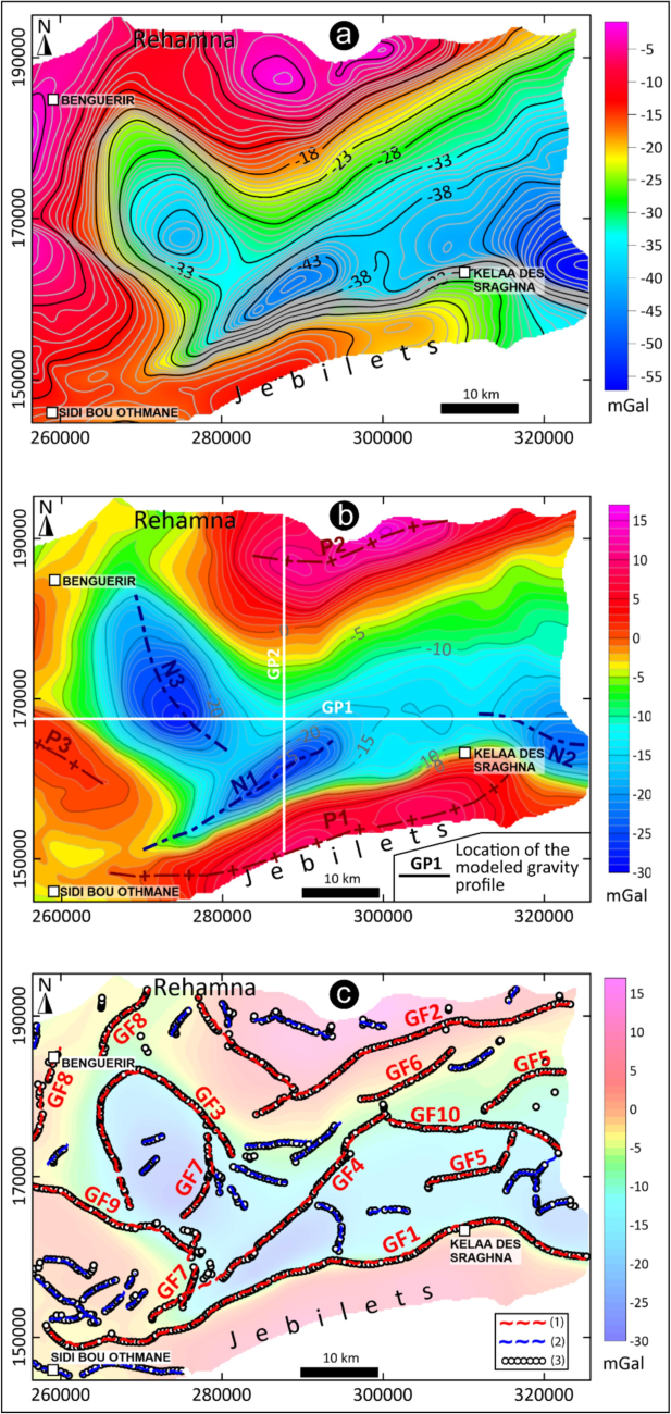
(a) Bouguer anomaly map of the study area. (b) Map of residual anomalies of the study area. (c) Map showing (1) major and (2) minor geological contacts derived from (3) the maxima of the calculated horizontal gradient. GFx: Gravity Fault. GPx: Gravity Profile. Nx: Negative anomaly. Px: Positive anomaly.
Geological contacts related to density contrasts between two adjacent formations are better characterized by calculating the horizontal gradient. This operation, carried out on the residual anomaly map, has allowed the identification of the main non-outcropping geological contacts. Fig. 2c shows the maxima of the horizontal gradient obtained for the main alignments, superimposed on the residual anomaly map of the EBB. The identified alignments GF1 and GF2 correspond to the contacts of the Paleozoic basement of Jebilet and Rehamna with the sedimentary cover of the EBB. Alignment GF3 corresponds to the contact between the granitic massif and the sedimentary cover of the basin. In addition, we have identified two families of intra-basin contacts: contacts GF4, GF5, GF6, GF7 and GF8 are broadly NE-SW trending (N50 to N60). They probably correspond to faults that controlled the emplacement of the sedimentary cover and are probably inherited from reactivated Hercynian faults during the Atlassian orogeny (Karroum, 2015). Contacts GF9 and GF10, oriented N110 and N120, are also attributed to reactivated Hercynian faults. These major contacts delineate different blocks in the sedimentary cover and basement, roughly facilitating a stair-step structure from north to south of the basin.
The geological map of the EBB does not allow the identification of faults corresponding to these contacts. These are expected to appear on the surface as zones with intense fracturing, such as those observed in the phosphate mining trenches near the city of Benguerir. Although not mapped at the surface, these identified contacts represent potential recharge zones for the studied groundwater aquifers, which correspond to the karstified limestones of the Lutetian and Turonian (Jaffal et al., 2022; Lghoul et al., 2023). These faults, identified through the interpretation of gravimetric data, have certainly played an important role in the distribution of formations and the thickness of the sedimentary cover, facilitating the establishment of depocenters, particularly on the southern side of the basin. They therefore play a role in controlling the characteristics of the studied aquifers and the groundwater flow.
4.2 Interpretation of seismic data
The interpretation of the seismic data focused primarily on the identification of reflectors corresponding to the main aquifers being investigated and the tracking of these reflectors along the available SP1 and SP2 seismic profiles. This identification was facilitated by available drilling data and a geological cross section established in the central part of the basin.
The interpretation of the seismic sections was based on data from boreholes TAN101, 2143/44 and 4111/44, which provided the actual depths of the main aquifers investigated. Fig. 3a shows the reflectors attributed to the Turonian karstic limestones, the upper Triassic, and the Paleozoic basement, identified on seismic section SP1, as well as the interpreted faults SF1, SF2 and SF3. Fig. 3b shows the GP1 residual gravimetric profile. The negative gravimetric anomaly to the west of the profile coincides with the presence of a granitic massif with a density of 2.4 g/cm3 compared to 2.67 g/cm3 for the sedimentary cover. The density values assigned to these two units were determined based on available information on the local geology of the study area (e.g., Khalil, 1989; Er-Rouane, 1996; Karroum, 2015) and general knowledge of rock densities measured from rock samples (Telford et al., 1990; Sharma, 1997). These values were chosen because they provide the best overlap between the calculated and observed anomalies. The negative anomaly at the eastern end of the profile is explained by the presence of diapirs, which sometimes materialize in this area. This salt diapir is not completely clear on the seismic section but its interpretation is approximated on SP1 profile.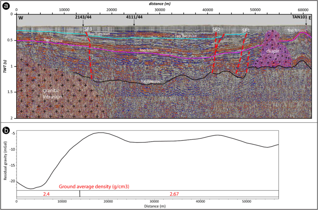
(a) Interpreted seismic section SP1. (b) Residual gravimetric profile GP1. SFx: Seismic Fault.
The seismic reflector corresponding to the Eocene aquifer could not be identified in this section due to its shallow depth. The one corresponding to the Turonian limestones is at a depth of approximately 300 m, as indicated in boreholes 4111/44 and 2143/44 and can be easily tracked along the examined seismic section. The depth of this aquifer across the central part of the EBB can therefore be approximately predicted.
Fig. 4a shows the location of the seismic reflectors attributed to the main aquifers of the EBB, corresponding respectively to the top of the Lutetian Thersites limestone slab and the top of the Turonian karstic limestones. It also shows the seismic reflectors attributed to the Triassic and Paleozoic tops. The position of the latter two reflectors on this section has been correlated to the equivalents markers on section SP1 at the intersection point of the two seismic profiles. This figure illustrates the general configuration of the deep structure of the sedimentary cover in this basin, which is clearly controlled by major E-W and NE-SW trending faults. Those intersected by seismic profile SP2 correspond to the interpreted faults SF2, SF4 and SF5. The gravimetric profile GP2 (Fig. 4b) explains the negative gravimetric anomaly N1, which corresponds to a large depression filled with sedimentary deposits in the vicinity of the Hercynian Jebilet massif. The density contrast between the two geological formations is responsible for the N1 anomaly.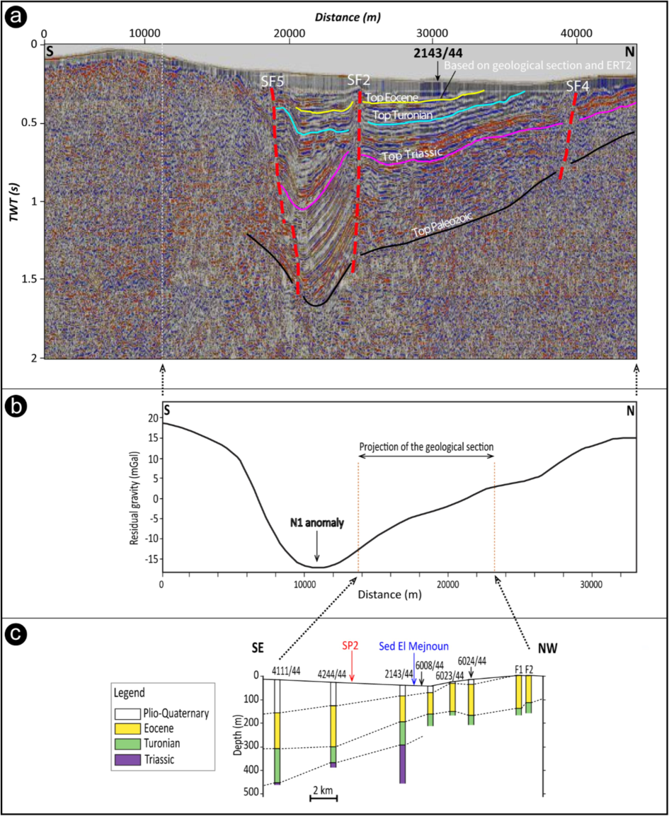
(a) Interpreted seismic section SP2. SFx: Seismic Fault. (b) Residual gravimetric profile GP2. (c) Geological section generated from borehole data used to verify the position of the seismic reflectors.
The seismic reflector corresponding to the Eocene aquifer is located at a depth of approximately 100 m, as indicated by borehole 2143/44 and verified by the established geological cross-section (Fig. 4c). The tracking of this reflector along the examined seismic section provides an estimate of its average depth, which may exceed 200 m towards the south, due also to the activity of the fault SF2. The reflector corresponding to the Turonian limestones is variably positioned, starting at a depth of approximately 100 m north of fault SF2 and extending to over 400 m in depth in region situated between faults SF2 and SF5.
The combined analysis of gravimetric and seismic data allows the correspondence of gravimetric faults with interpreted seismic faults. The locations of the gravimetric faults (GF1, GF2, GF4, GF5, GF7) revealed by the calculation of the horizontal gradient coincide with the interpreted seismic faults SF5, SF4, SF2, SF1 and SF3 respectively. These faults, which do not appear at the surface, are important structures rooted in the Paleozoic basement. They have probably controlled the sedimentation of the sedimentary cover in the EBB by promoting depocenters in the southern part of the basin. These geological structures should have a significant hydrogeological control on the thickness of the main studied aquifers, their recharge, and their deep hydrodynamics (Jaffal et al., 2022; Lghoul et al., 2023). Indeed, it is evident that the thickness of the aquifers increases towards the south, following the general evolution of the rest of the sedimentary cover. In particular, the interpreted faults (GF1 and GF2), which bring the Paleozoic Jebilet and Rehamna massifs into contact with the sedimentary cover, should play a predominant role in the recharge of the studied aquifers. Those located in the central part of the basin, covered by the less permeable Plio-Quaternary cover, are expected to play a moderate role in this recharge.
4.3 Subsurface geoelectrical models
Despite the limited depth of investigation of the electrical resistivity survey that we recently carried out in the central part of the EBB, the obtained geoelectric models (ERT1 and ERT2) offer a valuable insights into the geometry of the Plio-Quaternary formation. The models reveal that the imaged subsurface layers are dominated by highly conductive facies, which is attributed to the high salinity content of the sediments. These high conductivity zones are indicative of saline water saturation, which a common feature in the Plio-Quaternary aquifers in arid and semi-arid regions.
The detailed analysis of these models shows distinct electrical resistivity variations across different subsurface layers. Fig. 5 illustrates the main subdivisions of the Plio-Quaternary formation based on the ERT1 profile, where the uppermost layers correspond to more conductive units, suggesting a high salt concentration, likely due to evaporation processes and the limited recharge of fresh water in the basin. These conditions are consistent with previous hydrogeological studies that highlighted the challenges of water salinity in the EBB (El Mokhtar et al., 2012; Karroum, 2015).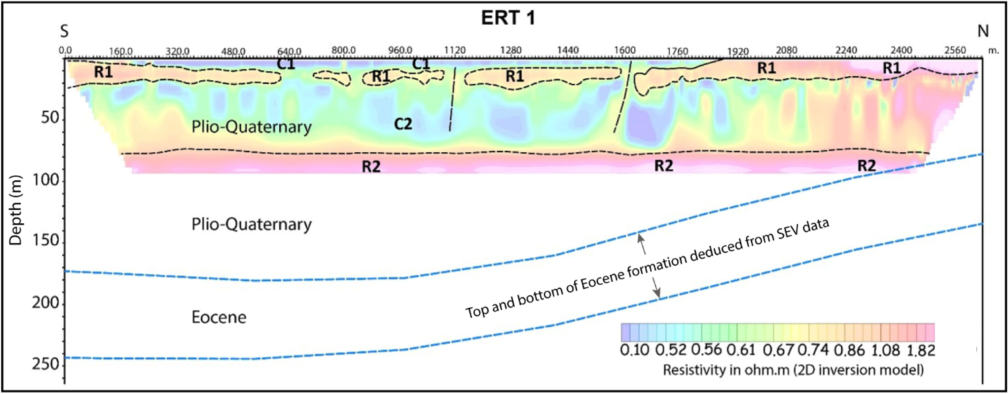
Geoelectric models obtained by inversion of data from profiles ERT1 and ERT2 showing conductive (C) and Resistive (R) geologic units.
The geoelectrical models also show that the base of the Plio-Quaternary formation is located beyond the 100-meter depth, where the resistivity values suggest a transition from the saline aquifer to the underlying Eocene limestone aquifer (Thersites slab). The VES data acquired earlier by CGG complement these models by providing constraints on the depth to the top of the Eocene aquifer, which deepens progressively from north to south, reaching a maximum depth of approximately 180 m (Fig. 5). This gradual deepening reflects the structural dip of the sedimentary layers, controlled by regional tectonics and fault systems.
The analysis of the electrical resistivity tomography, coupled with the VES data, indicates that the Plio-Quaternary formation though saline, plays a significant role in controlling the recharge dynamics of the Eocene aquifer. The salinity observed in the shallow aquifers may act as a barrier to fresh groundwater recharge in certain areas, which has implications for the long-term sustainability of groundwater resources in the region.
Moreover, the integration of the geoelectrical models with the seismic reflector positions from the SP2 seismic section enabled us to more accurately constrain the depth and extent of the Eocene aquifer. The ERT data provided a higher-resolution near-surface image, while the seismic data offered insights into the deeper structures, such as the Lutetian limestones and their role in forming the lower boundary of the aquifer system. The combined use of these methods has allowed us to better understand the hydrogeological potential of the Eocene aquifer and its relation to the overlying Plio-Quaternary deposits.
4.4 Potential hydrogeological prospects
Fig. 6 provides a comprehensive view of the regional structural framework and its hydrogeological implications in the EBB. The map illustrates key features such as structural highs, structural lows, granitic intrusions, regional faults, and zones with varying hydrogeological prospects (ranging from moderate to very good). This figure is essential for understanding the interaction between deep structures and groundwater systems within the basin.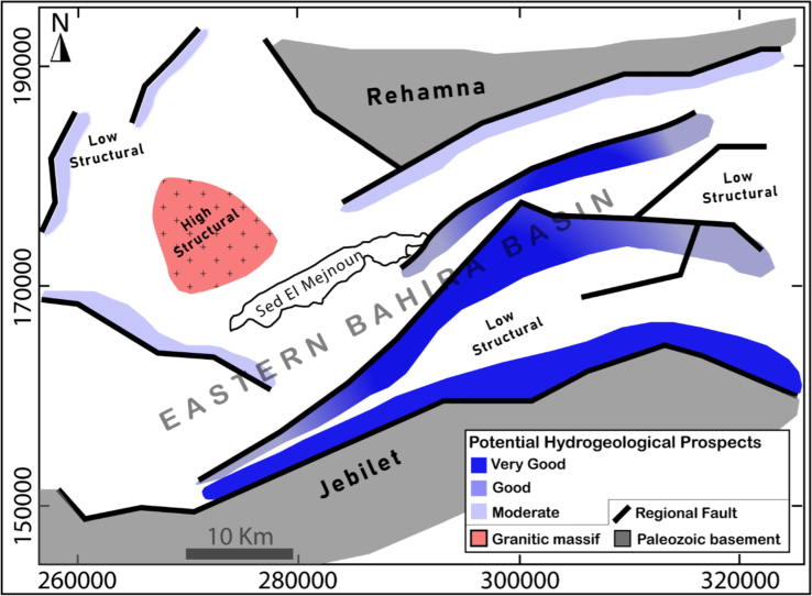
Map synthesizing the major features of the deep structure of the EBB and their hydrogeological implications.
The structural framework, which is roughly an asymmetric syncline, plays a crucial role in controlling the distribution and recharge potential of groundwater. The geological lineaments derived from the gravimetric data are consistent with the interpreted seismic faults, further confirming their role in shaping the deep structure of the EBB. These structures control the overall geometry of the sedimentary cover, which is generally monoclinal and dips slightly towards the southeast. Notably, a large ENE-WSW trending sub-basins trough in the southern part of the EBB (blue areas in Fig. 6) corresponds to areas of increased sediment accumulation, which are likely potential zones for groundwater storage.
In the central part of the basin, the newly acquired ERT data have provided more detailed imaging of the structural low in the Sed El Mejnoun depression, clearly identifying the depth and extent of its basement. The geoelectrical models also reveal the deeper continuation of the geological formations that outcrop to the north of this depression. These formations play a crucial role in controlling the movement and storage of groundwater, making the Sed El Mejnoun area a potential zone for further hydrogeological investigation.
This map also highlights major geological contacts rooted in the Paleozoic basement, which have been inherited from the Hercynian orogeny. These contacts have controlled on the one hand, the sedimentation of the Mesozoic and Cenozoic cover in the EBB and, on the other hand, the present structure shaped by the Atlasic orogeny. The subvertical nature of the faults, with their predominant southern dip (except for fault 5, which dips northward), suggests that these structures serve as important conduits for groundwater flow. Their stair-step configuration from NW to SE controls the distribution of aquifers and influences recharge areas within the basin.
Additionally, the study has characterized the structural high associated with a sub-outcropping granitic intrusion in the western part of the EBB. This granitic intrusion likely affects the local permeability and groundwater flow, leading to variations in groundwater availability in the surrounding areas. Such structural highs may limit groundwater storage but could also influence deeper aquifer recharge in nearby faulted zones.
4.5 Hydrogeological implications
The precision of the deep geological structure of the EBB clearly has direct hydrogeological implications: The study shows that the Plio-Quaternary formation, which covers the unconfined aquifer of the EBB, is particularly thick in the central part of the basin and can reach a thickness of 200 m in the Sed El Mejnoun depression. Deeper down, the geological structures defined by this study would control the thickness and functioning of the Eocene and Turonian aquifers. In fact, the thickness of these two aquifers is expected to follow the overall evolution of the sedimentary cover, as outlined above. Thus, this thickness would be greater in the structural lows delineated by the identified geological contacts. These contacts also control the depth of the two main aquifers investigated. The depths of these aquifers, inferred from the interpretation of seismic sections and verified by borehole data and the established geological cross section, vary from 200 to 400 m for the Eocene aquifer and from 300 to over 450 m for the Turonian aquifer. Furthermore, the faults interpreted in this study undoubtedly play a predominant role in the recharge of these two main aquifers of the EBB and in their hydrodynamic functioning. Faults GF1 and GF2, which materialize the contact between the Jebilet and Rehamna massifs and the sedimentary cover of the EBB, should play an important role in the infiltration of meteoric water into these aquifers. Faults GF3 to GF10, which are not mapped at the surface, should also play the same role but possibly with a lower importance. In addition, all these major faults would also represent preferential zones for groundwater flow. Consequently, areas of obvious hydrogeological interest would be the deep intersection of these faults with the aquifer horizons, particularly in the structural lows. Drilling to access the Eocene and Turonian aquifers should therefore be carefully placed to target such perimeters. Fig. 6 highlights the most promising hydrogeological prospects in the EBB. By illustrating the relationships between geological structures and the hydrodynamics of groundwater aquifers, our study highlights the importance of compilation and combined analysis of geological and geophysical data, even in a lesser-known basin, to better guide drilling campaigns for groundwater exploitation and to meet the needs for drinking water and irrigation in a region where this is a major challenge.
5 Conclusions
This study has provided new insights into the deep geological and hydrogeological structure of the EBB through a combined analysis of geological and geophysical data. Its findings help compensate for the lack of documentation on this part of the Bahira basin.
The study revealed that the Plio-Quaternary aquifer is characterized by high salinity, which impacts its potential for sustainable use in irrigation and drinking water. The ERT models, along with the reinterpretation of VES data, provided valuable constraints on the depth and extent of the Eocene aquifer, suggesting that its thickness and distribution are controlled by regional fault systems. These findings underscore the importance of structural controls on groundwater flow and recharge processes within the basin.
In addition, the integration of seismic and gravimetric data helped refine the understanding of deeper structures, particularly the Lutetian and Turonian limestone units, which play a crucial role in the aquifer system. The identified regional faults and structural depressions represent promising targets for groundwater exploitation, particularly in the southern and central parts of the basin.
The methodology applied in this study has proven to be effective in addressing the challenges of aquifer characterization in arid regions like the EBB. The findings have direct implications for improving groundwater resource management, contributing to more effective strategies for addressing water scarcity in the region. Future research should focus on further refining the structural models and expanding geophysical surveys to cover adjacent areas of the basin to enhance groundwater exploitation potential.
CRediT authorship contribution statement
Anas Charbaoui: Writing – review & editing, Writing – original draft, Visualization, Validation, Supervision, Software, Resources, Methodology, Investigation, Formal analysis, Data curation, Conceptualization. Mourad Guernouche: Visualization, Validation, Supervision, Software, Resources, Methodology, Investigation, Formal analysis, Data curation, Conceptualization. Azzouz Kchikach: Writing – review & editing, Writing – original draft, Visualization, Validation, Supervision, Software, Resources, Project administration, Methodology, Investigation, Funding acquisition, Formal analysis, Data curation, Conceptualization. Mohammed Jaffal: Writing – review & editing, Writing – original draft, Visualization, Validation, Supervision, Software, Resources, Project administration, Methodology, Investigation, Funding acquisition, Formal analysis, Data curation, Conceptualization. Abdessamad Hadri: Resources, Methodology, Investigation, Formal analysis, Conceptualization. Mihai Octavian Cimpoiasu: Writing – review & editing, Validation, Formal analysis. Samuel Zappalá: Writing – review & editing, Validation, Software, Methodology, Formal analysis. Mounir Amar: Resources, Methodology, Investigation, Formal analysis, Data curation, Conceptualization. Oussama Khadiri Yazami: Writing – review & editing, Validation, Methodology, Formal analysis, Conceptualization.
Acknowledgment
This research was supported by the Moroccan Ministry of Higher Education, Scientific Research and Innovation and the OCP Foundation within the framework of the APRD research program.
Declaration of competing interest
The authors declare that they have no known competing financial interests or personal relationships that could have appeared to influence the work reported in this paper.
References
- Assessment of groundwater aquifer using geophysical and remote sensing data on the area of Central Sinai, Egypt. Sci. Rep.. 2023;13(1) Springer Science and Business Media LLC
- [CrossRef] [Google Scholar]
- Joint Gravity and Seismic Reflection Methods to Characterize the Deep Aquifers in Arid Ain El Beidha Plain (Central Tunisia, North Africa) Water. 2021;13(9):1310. MDPI AG
- [CrossRef] [Google Scholar]
- Seismic reflection and structuring characterization of deep aquifer system in the Dakhla syncline (Cap Bon, North-Eastern Tunisia) J. Afr. Earth Sc.. 2018;140:134-150. Elsevier BV
- [CrossRef] [Google Scholar]
- The emergence of hydrogeophysics for improved understanding of subsurface processes over multiple scales. Water Resour. Res.. 2015;51(6):3837-3866.
- [CrossRef] [Google Scholar]
- Approximating edges of source bodies from magnetic or gravity anomalies. Geophysics. 1986;51(7):1494-1498. Society of Exploration Geophysicists
- [CrossRef] [Google Scholar]
- État des connaissances sur le plateau continental marocain et ses dépôts phosphatés. Mines, Géologie et Énergie. 1971;25:15-52.
- [Google Scholar]
- Bruno, P. P. G., & Vesnaver, A., 2021. Groundwater characterization in arid regions using seismic and gravity attributes: Al Jaww Plain, UAE. In Frontiers in Earth Science (Vol. 8). 10.3389/feart.2020.575019. Frontiers Media SA.
- Contribution à l’étude géologique du gisement de phosphate Crétacé-Éocène des Ganntour (Maroc Occidental). Université Louis-Pasteur de Strasbourg—Institut de géologie. Sci. Géologiques. 1976;43:244.
- [Google Scholar]
- New Insights from Geophysical, Hydrogeological and Borehole Data into the Deep Structure of the Louta Phosphatic Deposit (Gantour Basin, Morocco): Mining Implications. In. Geosciences. 2023;13(12):357. MDPI AG
- [CrossRef] [Google Scholar]
- Cox, D. R., Newton, A. M. W., Huuse, M., 2020. An introduction to seismic reflection data: acquisition, processing and interpretation. In Regional Geology and Tectonics: Principles of Geologic Analysis (pp. 571–603). 10.1016/b978-0-444-64134-2.00020-1. Elsevier.
- Understanding the Gravity Response Variability of Sedimentary Basins Using Forward Stratigraphic Modelling. 2020;122:104698.
- [CrossRef]
- Geophysics for the Mineral Exploration Geoscientist. Cambridge: Cambridge University Press; 2014.
- Applied Regression Analysis. In: Wiley Series in Probability and Statistics. Wiley; 1998. 10.1002/9781118625590
- [Google Scholar]
- Phosphatic series under Plio-Quaternary cover of Tadla Plain, Morocco: Gravity and seismic data. In Comptes Rendus. Géoscience. 2019;351(6):420-429. Cellule MathDoc/Centre Mersenne
- [CrossRef] [Google Scholar]
- Salinisation des eaux souterraines aux alentours des sebkhas de Sad Al Majnoun et Zima (plaine de la Bahira, Maroc) Secheresse. 2012;23:48-56.
- [CrossRef] [Google Scholar]
- Gravimetry Contribution to the Study of the Bahira Aquifer (Morocco) - Hydrogeological Implication. In: Proceedings. near Surface Geoscience 2016–22nd European Meeting of Environmental and Engineering Geophysics. EAGE Publications BV; 2016. 10.3997/2214-4609.201602072
- [Google Scholar]
- Mise en œuvre D’outils Informatisés Pour la Modélisation du Système Aquifère de la Plaine de la Bahira (Maroc occidental). Marrakech, Morocco: Université Cadi Ayyad; 1996. Ph.D. Thesis
- Florio, G., 2020. The Estimation of Depth to Basement Under Sedimentary Basins from Gravity Data: Review of Approaches and the ITRESC Method, with an Application to the Yucca Flat Basin (Nevada). In Surveys in Geophysics (Vol. 41, Issue 5, pp. 935–961). 10.1007/s10712-020-09601-9. Springer Science and Business Media LLC.
- Geophysical data revealing the control of geological structures in the El Gouna springs in Souss river valley in Morocco. In: Groundwater for Sustainable Development. Vol Vol. 15. Elsevier BV; 2021. p. :100669.
- [CrossRef] [Google Scholar]
- Geophysical Prospecting for Groundwater Resources in Phosphate Deposits (Morocco) In Minerals. 2020;10(10):842. MDPI AG
- [CrossRef] [Google Scholar]
- Contribution à l’étude d’une partie du bassin d’Essaouira (Maroc) par sismique réflexion. c. r. Geoscience. 2002;334:229-234.
- [Google Scholar]
- Gravity study of the Western Bahira Basin and the Gantour Phosphatic Plateau, central Morocco: Interpretation and hydrogeological implications. J. Afr. Earth Sc.. 2022;193:104581. Elsevier BV
- [CrossRef] [Google Scholar]
- L’apport de la Géophysique et de la Géochimie Dans l’identification Hydrogéologiques et la Qualité des Eaux de la Plaine de la Bahira (Maroc centrale). Marrakech, Morocco: Université Cadi Ayyad; 2015. Ph.D. Thesis
- Fonctionnement hydrogéologique du bassin de la Bahira (Maroc central): apport de l’analyse des données géologiques et gravimétriques. Canadian Journal of Earth Sciences. 2014;51(5):517-526. Canadian Science Publishing
- [CrossRef] [Google Scholar]
- Geochemical processes controlling groundwater quality under semi arid environment: A case study in central Morocco. Sci. Total Environ.. 2017;609:1140-1151.
- [CrossRef] [Google Scholar]
- An Introduction to Geophysical Exploration. Oxford: Blackwell Science Ltd.; 2002.
- Contribution à l’étude Hydrogéologique de la Plaine de la Bahira (Maroc Central). Marrakech, Morocco: Université Cadi Ayyad Marrakech; 1989. Ph.D. Thesis
- Groundwater exploration in limestone–shale–quartzite terrain through two-dimensional electrical resistivity tomography in Tadipatri, Anantapur district, Andhra Pradesh. J. Earth Syst. Sci.. 2020;129(1) Springer Science and Business Media LLC
- [CrossRef] [Google Scholar]
- Application of enhanced methods of gravity data analysis for mapping the subsurface structure of the bahira basin in Morocco. Front. Earth Sci.. 2023;11 Frontiers Media SA
- [CrossRef] [Google Scholar]
- Loke, M.H., 2010. Res2Dinv ver. 3.59 for Windows XP/Vista/7, 2010. Rapid 2-D Resistivity & IP Inversion Using the Least-Squares Method. Geoelectrical Imaging 2D & 3D Geotomo Software 2010, Malaysia.
- Elément de Géologie Marocaine. Rabat, Morocco: Notes et Mémoires du Service Géologique du Maroc; Éditions du Service Géologique du Maroc; 1976.
- Gravity and electrical resistivity analysis of deep and shallow structures related to aquifers within the Jeffara Plain, southeast Tunisia. J. Afr. Earth Sc.. 2022;196:104685. Elsevier BV
- [CrossRef] [Google Scholar]
- Exploring hydrogeological parameters by integration of geophysical and hydrogeological methods in northern Khartoum state, Sudan. Groundw. Sustain. Dev.. 2023;20:100891. Elsevier BV
- [CrossRef] [Google Scholar]
- La integración de datos geológicos, hidrogeológicos y geofísicos con el fin de identificar los recursos de aguas subterráneas en zonas de basamento granítico (Macizo de Guéra, Chad) Hydrgeol. J.. 2024;32(3):759-784. Springer Science and Business Media LLC
- [CrossRef] [Google Scholar]
- Géologie du Maroc. GEODE: Marrakech, Morocco; 2007.
- Géométrie de l’aquifère du Haouz oriental et Tassaout amont, Maroc occidental: approche géophysique et hydrogéologique. Hydrological Sciences Journal. 2014;60(1):133-144. Informa UK Limited
- [CrossRef] [Google Scholar]
- Understanding the structural framework controlling the sedimentary basins from the integration of gravity and magnetic data: A case study from the east of the Qattara Depression area, Egypt. Journal of King Saud University - Science. 2022;34(2):101808. Elsevier BV
- [CrossRef] [Google Scholar]
- The integration of gravity, magnetic and seismic data in delineating the sedimentary basins of northern Sinai and deducing their structural controls. J. Asian Earth Sci.. 2016;115:345-367. Elsevier BV
- [CrossRef] [Google Scholar]
- Sharma, P. V., 1997. Environmental and engineering geophysics. Cambridge University Press. Everett M. E., 2013. Near-surface applied geophysics. 10.1017/CBO9781139088435.
- Investigation of a sedimentary basin by using gravity and seismic reflection data in the Isparta basin, southwestern Turkey. Bulletin of Engineering Geology and the Environment. 2020;79(8):3971-3988. Springer Science and Business Media LLC
- [CrossRef] [Google Scholar]
- Seismic Data Analysis. Societyof Exploration Geophysicists. 2001;10(1190/1)
- [CrossRef] [Google Scholar]


