

Translate this page into:
Soil quality assessment in the Araban plain across various land use types
⁎Corresponding author at: Department of Herbal Production and Technologies, Faculty of Applied Science, Muş Alparslan University, Muş, Turkiye omer.celik@alparslan.edu.tr (Ömer Çelik),
-
Received: ,
Accepted: ,
This article was originally published by Elsevier and was migrated to Scientific Scholar after the change of Publisher.
Abstract
Background
Soil is an important resource for improving the quality of human well-being and creating sustainable environmental awareness. Therefore, it is imperative to protect the soil health. This study determined quality of the soils in the Araban plain, Türkiye using three different methods, i.e., principal component analysis (PCA), analytic hierarchy process (AHP), and expert opinion (EO). The major aim was to determine the most appropriate method for determining soil quality and recommending soil protection practices for improving quality.
Methods
This study was conducted on an area of approximately 25,000 ha. A total of 230 soil samples (7 pasture areas, 56 orchards, and 167 arable crops) were analyzed to determine key soil quality indicators. A minimum dataset consisting of parameters that best represent the soils of the region was created. Subsequently, PCA was used to predict soil quality with the optimal accuracy using the least amount of data. The EO was incorporated to validate the PCA results. The AHP was used to assign weights to the parameters. Indicators at all sampling points were converted to unitless scorers. These scores were then formulated as soil quality index (SQI) using the weighted summation method.
Results
Organic matter (OM) exerted the highest impact on soil quality. Significant variations in SQI values were observed among arable land, orchards land and pastureland (P < 0.01). Significant variations were recorded in SQI values of the assessment methods employed in this study. The lowest (0.552) and highest (0.829) SQI values were recorded for AHP and EO, respectively. Overall, streamlining indicators through PCA gave the most accurate result for SQI value. Subsequently, SQI determination should involve weighing with AHP, particularly towards EO.
Conclusion
The AHP was found to be the most appropriate method for evaluating soil quality in Araban. This integrated approach ensures a robust evaluation of soil quality, facilitating more accurate and nuanced insights for informed land management decisions. Overall, 92.61 % of the region’s soil had poor and medium soil quality. Therefore, increasing OM content and aggregate stability are suggested to improve soil quality in the study region.
Keywords
Soil quality indicators
Land use impact
PCA optimization
Expert validation
Weighted SQI
Integrated land management

1 Introduction
Increasing global population, improved living standards, and the depletion of natural resources have exaggerated soil degradation. Soil degradation is a crucial issue of the modern era, which is defined as decreasing productive capacity of a land and characterized by a decline in soil quality resulting in disturbed ecosystem functions and services (Lal, 2020). Soil quality is known as the ability of the soil to support plant growth, regulate infiltration and distribution of water, protect watersheds, and mitigate potential pollutants such as agricultural chemicals, organic wastes and industrial chemicals. It plays a vital role in preventing water and air pollution (Yang et al., 2020).
Soil is essential for food production in terrestrial ecosystem, and consequently human life. The relationship between the ability of people to lead a healthy life and soil quality has become inseparable (Selmy et al., 2021). It is crucial to maintain the dynamic balance between soils and the environment considering the inherent limitations of soils, their irreplaceability when degraded (Abdu et al., 2023), and the constant changes caused by human activities and climate change. However, inappropriate soil management practices deteriorate this delicate balance, highlighting the importance of determining and interpreting variability for soil quality assessment (Bone et al., 2014).
Soil quality is defined as the ability of soil to fulfil its functions. Soil quality is a key factor for environmental sustainability and food security; therefore, it is imperative to understand soil quality and implement appropriate management practices for optimal crop yields (Abdu et al., 2023). However, improper land use, burning of crop residues, industrialization, mechanization and improper use of fertilizers and pesticides to cause significantly to soil degradation (Wallace and Terry, 2020). Therefore determining, monitoring and improving soil quality is important for addressing future food requirement, ensuring air and water quality, sustaining the health of plants, animals, humans and the environment, and mitigating the impacts of climate change. Several studies have been conducted to understand and improve changes in soil quality around the world (Murthy and Author, 2023).
This assessed the SQI in the Araban Plain, Gaziantep province, Türkiye by determining a range of biological, chemical and physical indicators. Araban Plain is considered a suitable area for evaluating and monitoring soil quality since more than one crop is harvested per year. Plants requiring intense and less irrigation are grown in the same region, resulting in different land use types, i.e., arable land, orchards land and pastureland. There is intense agricultural vehicle traffic in the region which could significantly alter soil quality. It was hypothesized that the soils belonging to different land use types would have varying soil quality. The results would help to identify the factors that negatively affect soil quality and help to recommend soil management practices for improving soil quality.
2 Materials and methods
2.1 Study area
This study was conducted in the Araban Plain, situated within the Gaziantep Province (longitudes 37° 24′ 09′' − 38° 12′ 20′' and latitudes 37° 29′ 16′' − 37° 13′ 16′') (Fig. 1). The Araban Plain is in the northeast of the province, ∼70 km away from the city center. It is surrounded by the Besni district of Adıyaman province to the east, the Karadağ and Yavuzeli districts to the south, the Halfeti and Bozova districts of Şanlıurfa province in the north, and the Pazarcık district of Kahramanmaraş province to the west. The plain has an altitude of 700 m and spans over an area of 542 km2. The local economy is predominantly based on agricultural activities, including both large and small scale livestock farming as well as the cultivation of garlic, cotton, wheat, barley, watermelons, lentils, chickpeas, viticulture and pistachios (IKTM, 2023).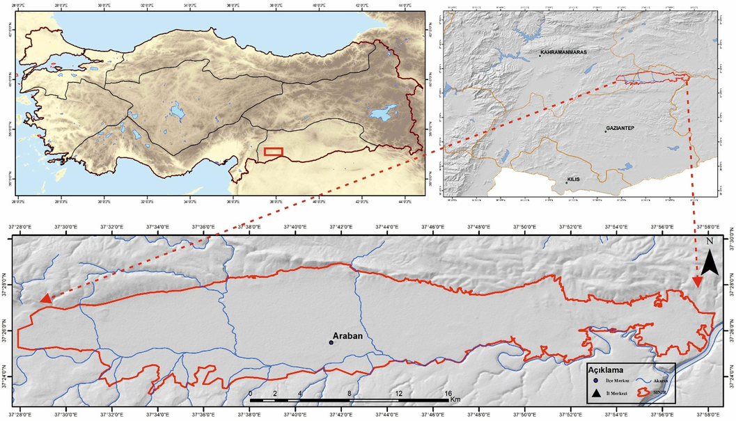
Geographic location of the study area.
Araban district is a colluvial plain, situated between high mountains to the north and south. While valley elevations drop to about 370 m, average elevation is ∼ 600 m, designating lower elevations areas as prime farmland. The main water sources include the Euphrates River in the east and the Karasu River in the west. The Araban Plain generally has a temperate climate, with higher precipitation is in the winter months and low levels in the summer. The annual average temperature is 16.9 °C, accompanied by an average annual precipitation of 525 mm. The northern regions reveal the Midyat Formation from the middle Eocene at higher altitudes, while depressions in plain (south parts) showcase the Fırat Formation from the Oligo-Miocene The western parts feature basalt from the Quaternary (Pleistocene), alongside sediments from the Pleistocene and Holocene on the plain and valley floor.
2.2 Soil sampling
The boundaries of study area were defined using the ArcGIS software. The study area was then systematically divided into square grids with a width of 1100 m. A total of 230 sample points were collected from a depth of 0–20 cm. The sampling locations included 7 pasture areas, 56 orchards, and 167 arable crops. The collected soil samples passed through a series of preparatory steps, including drying at room temperature and sieving through a 2 mm sieve for soil analyses.
2.3 Laboratory analysis
Various soil physical, chemical, and biological analyses were carried out using standard soil analysis methods. Soil pH and electrical conductivity (EC) were measured in the saturation paste following the methods outlined by Rhoades et al. (1999). Calcium carbonate (CaCO3) content was determined using the Scheibler calcimeter method (Kacar, 1994). Soil texture was assessed through dispersion with sodium hexametaphosphate (Gee and Bouder, 1986), using a Bouyocous cylinder and hydrometer. Organic matter (OM) content was determined using the modified Walkley-Black method (Nelson and Sommers, 1982). Plant-available phosphorus was calculated based on spectrophotometric measurements proposed by Olsen and Sommers (1982). Plant-available potassium was determined using the 1-N-ammonium acetate method and calculated using atomic absorption spectrophotometry (Thomas, 1982). Aggregate stability (AS) was determined using the wet sieve method (Kemper 1986), and bulk density (BD) was determined using the cylinder method (Blake and Hardge, 1986). In cases where undisturbed soil samples could not be collected, bulk density was estimated using pedotransfer functions as reported by Rawls (1983). Microbial biomass carbon (MBC) was determined using the method proposed by Isermayer (1952).
2.4 Soil quality assessment
Soil quality assessment consisted of three steps. Initially, the indicators for the minimum dataset were identified. Subsequently, the selected indicators were scored Table 1. Finally, the values of the individual indicators were integrated into the SQI to assess overall soil quality (Andrews et al., 2004). Afterwards, descriptive statistics of soil properties were computed (Table 2). Finally, Kaiser–Meyer–Olkin (KMO) and Bartlett’s was used to infer the differences among soil properties of different land use types (Table 3). AS = aggregate stability, CaCO3 = calcium carbonate, OM = organic matter, pH = soil reaction, EC = electrical conductivity, BD = bulk density, MBC = microbial biomass carbon, K = potassium, P = phosphorus.
Indicators
Threshold value
Scoring Curve
Reference
pH
5.5–7.2
Optimum is better
Mukherjee & Lal (2014)
EC
dS m−1
0.2–0.8
Optimum is better
Mukherjee & Lal (2014)
Organic matter
%
2.50
More is better
Lima et al. (2013)
CaCO3
%
4.0–8.0
Optimum is better
TÜBİTAK (2017)
Potassium
mg kg−1
141–370
Optimum is better
FAO (1993)
Phosphorus
mg kg−1
10,9–21,4
Optimum is better
Andrews et al. (2004)
Aggregate Stability
%
>50.0
More is better
Andrews et al. (2004)
Bulk Density
Clay
1.10
Less is better
Andrews et al. (2004)
Sit
1.20
Sandy
1.40
Microbial biomass carbon
mg kg−1h−1
350
Less is better
Ghorai et al. (2022)
Indicator
Unit
Min.
Max
Mean
SD
CV
Skewness
Kurtosis
Orchard
AS
%
10.74
69.66
30.91
11.91
38.51
1.06
1.36
CaCO3
%
0.30
37.22
11.98
11.33
94.53
0.92
−0.31
OM
%
0.63
3.05
1.28
0.49
38.28
1.11
1.43
pH
7.96
8.50
8.18
0.09
1.06
0.15
0.74
EC
dS m−1
0.29
0.90
0.60
0.10
17.37
0.36
0.78
BD
g cm-3
1.21
1.42
1.31
0.03
2.60
−0.30
1.42
MBC
mg kg−1h−1
105.6
742.9
365.3
123.23
33.73
0.66
0.49
K
mg kg−1
249.3
505.3
335.3
50.73
15.13
0.55
0.48
P
mg kg−1
2.14
28.27
8.45
4.55
53.89
1.74
4.48
Arable Land
AS
%
10.21
89.67
40.11
14.97
37.32
0.66
0.37
CaCO3
%
0.30
37.22
11.91
9.09
76.32
0.81
−0.08
OM
%
0.49
2.63
1.25
0.38
30.40
0.58
0.23
pH
7.70
8.50
8.14
0.12
1.51
−0.38
0.89
EC
dS m−1
0.40
1.80
0.75
0.23
30.11
2.03
5.62
BD
g cm-3
1.23
1.52
1.32
0.04
2.66
1.92
9.30
MBC
mg kg−1h−1
201.7
860.2
429.72
118.75
27.63
0.63
0.31
K
mg kg−1
185.4
486.6
333.31
51.81
15.54
0.14
−0.43
P
mg kg−1
1.22
33.28
9.24
5.92
64.10
1.26
2.00
Pastureland
AS
%
38.74
72.32
50.10
10.80
21.55
1.09
0.57
CaCO3
%
0.97
8.11
2.88
2.41
83.59
1.51
0.92
OM
%
1.59
2.63
1.98
0.36
18.18
0.81
−1.04
pH
7.51
8.12
7.82
0.18
2.33
−0.07
−1.02
EC
dS m−1
0.45
1.41
0.81
0.28
35.25
1.20
0.57
BD
g cm-3
1.23
1.47
1.28
0.07
5.48
1.92
2.52
MBC
mg kg−1h−1
370.30
958.8
582.41
177.45
30.47
0.82
0.23
K
mg kg−1
263.10
439.9
336.41
47.11
14.00
1.12
0.91
P
mg kg−1
1.47
14.13
4.46
4.11
92.15
1.97
2.57
Arable Land
Orchard
Pastureland
KMO Sampling Adequacy
0.607
0.591
0.405
Bartlett's Test of Sphericity
Approx. Chi-Square
846.07
441.81
182.70
Degree of freedom
36
36
36
Significance
0.000
0.000
0.000
2.5 Determination of indicators
The data were divided into three different land use types, i.e., arable land, orchards and pastureland. In addition, a new dataset was created based on EO, leading to definition of two minimum datasets. These datasets were weighted using the AHP to determine their impact on soil quality. To reduce the number of indicators and minimize information loss in soil quality assessment, PCA was performed using SPSS software (version 25) (Chen et al., 2023). For each dataset, components with eigenvalues > 1.0 were considered as parameters expressing data variability effectively. The Varimax rotation transformation was utilized to enhance the correlation between the principal components and soil properties (Waswa et al., 2013). The parameters that met the selection criteria for each principal component were selected. The variable with the highest correlation sums and a loading value of <10 % among the variables with a variability correlation > 60 % in the dataset was retained as an indicator of soil quality. Conversely, other related parameters were excluded from the minimum dataset (Budak et al., 2018).
2.6 Scoring of soil quality indicators
Laboratory analysis results were converted into unitless scores between 0 and 1 using linear scoring curves (Budak et al., 2018). This scoring process involved three different scoring curves, i.e., “less is better”, “optimal is better” and “more is better”.
2.7 Statistical analysis
All data were tested for normality and equal variance, and those deemed necessary were transformed. Differences in soil properties, soil quality indicators, and SQI values between different land use types were statistically analyzed by one-way analysis of variance (ANOVA) using SPSS 25.0.
3 Results
The variables with the highest coefficient of variation (CV) in the orchards were CaCO3 (94.53 %), phosphorus (53.89 %), AS (38.51 %) and OM (38.05 %). Soil pH was slightly alkaline, non-alkaline with clay texture in orchard areas. Despite OM content ranged from 0.63 % to 3.05 %, 32 % of sampling sites have < 1 % OM content, 59 % had 1–2 % and only 9 % have > 2 % OM content Table 2.
The predominant crops in these areas include wheat (49 %), cotton (17 %) and garlic (16 %). Intensive arable farming is practiced, leading to significant vehicle traffic between sowing and harvesting. The variables with the highest CV in arable areas were CaCO3 (76.32 %) and phosphorus (64.10 %). Soil pH was slightly alkaline, with an average EC of 0.75 dS m−1 in arable soils. Most of the sampling sites (94 %) have a loamy soil texture, and the average OM content is the lowest compared to other land use types (1.25 %).
It becomes evident that factors such as phosphorus (92.15 %) and CaCO3 (83.59 %) have the highest CV. In comparison to other land use types, pasture areas have a higher average AS (50.1 %), lower BD (1.28 g cm−3) and higher OM content (1.98 %).
The PCA for orchards revealed the formation of 4 PC, which accounted for 70.35 % of the variance in the original data (Table 4). The PC1 included OM, BD, microbial biomass, carbon and AS. Due to the high correlation (r = −0.88) (Fig. 2-a) between OM and bulk density, and considering the highest loading value of OM, BD was not included in PC1. The PC2 incorporated factors such as CaCO3 and EC. The PC3 contained pH and potassium, while PC4 included phosphorus with the highest loading value. As there was no significant correlation among these parameters, all were included in the dataset Fig. 2. The factor loadings with high weight are denoted by bold font. The loadings that were kept in MVS from PCs are written in bold font and underlined.
Orchard N = 56
Arable Land N = 167
Pastureland N = 7
PC1
PC2
PC3
PC4
PC1
PC2
PC3
PC1
PC2
PC3
PC4
Aigen Values
2.63
1.45
1.21
1.04
2.46
1.58
1.22
2.87
2.42
1.85
1.05
% Variance
29.21
16.14
13.46
11.55
27.35
17.6
12.47
31.74
26.94
20.61
10.76
Cumulative Variance
29.21
45.34
58.8
70.35
27.35
44.96
57.42
31.74
58.67
79.28
90.04
OM
0.897
−0.225
−0.089
−0.158
0.791
0.380
−0.254
0.846
0.305
0.226
0.309
BD
−0.888
0.145
0.176
0.125
0.732
−0.130
−0.116
0.848
−0.014
−0.270
−0.073
MBC
0.652
−0.365
−0.109
−0.384
−0.677
−0.308
0.184
0.782
−0.019
−0.554
0.150
AS
0.549
0.123
0.283
0.355
0.566
0.196
0.024
0.494
0.523
0.527
−0.038
CaCO3
−0.004
−0.676
0.115
−0.351
−0.507
0.467
−0.206
−0.410
−0.686
0.157
0.453
EC
0.453
0.534
0.319
0.310
0.404
−0.507
0.500
−0.438
0.862
−0.119
0.025
pH
−0.140
0.164
0.778
−0.255
−0.129
0.694
0.036
−0.394
0.745
−0.450
−0.183
K
−0.202
−0.457
−0.599
0.036
0.127
−0.509
−0.560
−0.0.75
0.430
0.808
0.279
P
0.209
−0.504
−0.025
0.664
0.262
0.273
0.635
0.211
−0.321
0.500
−0.726
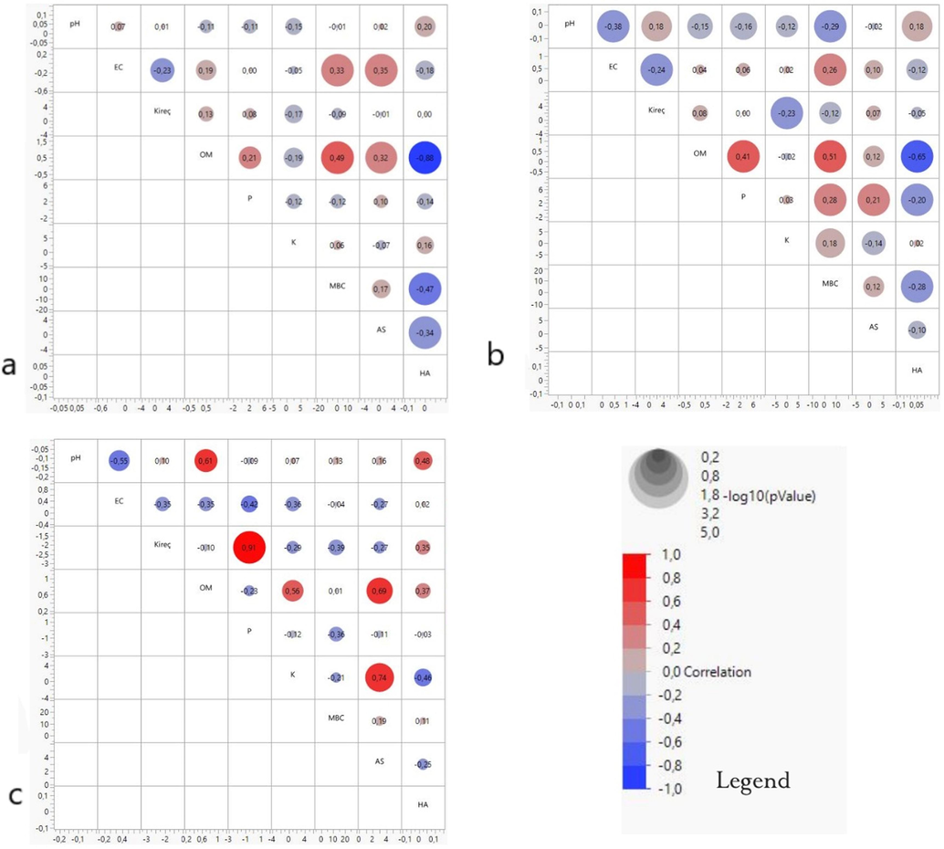
Correlation matrix of the soil properties orchard lands (a), arable lands (b), pasturelands (c) in the study area.
In the PCA test applied to the arable crop sampling sites, three PCs were formed, accounting for 57.42 % of the original data (Table 4). The parameters classified within the first principal component were OM, MBC, BD, phosphorus and pH. Due to the high correlation (r = 0.65) between OM and BD (Fig. 2-b) and because OM had the highest loading value, BD was removed from the principal component. The second PC included EC and lime, while the third PC included potassium and AS. As there was no correlation between these parameters, all data was included in the principal component.
The PCA of the pasture data and resulted in the formation of 4 PCs. These components accounted for 90.04 % of the total variation in the data. The first PC consisted of OM, AS and potassium. Due to the correlations of 69 % between OM and AS and 74 % between AS and potassium (Fig. 2-c), only OM was retained in the first PC. The second PC included CaCO3, EC and phosphorus. With a correlation of 91 % between these two parameters and the highest loading for CaCO3, phosphorus was removed from the principal component. The third PC consisted of bulk density and the fourth PC included only MBC.
The list of indicators and weights used to calculate the SQI for different land uses is shown in Table 5. Three different methods were used to calculate SQI. The SQI-AHP was calculated by multiplying the scores of the indicators obtained by PCA by the weights obtained by AHP. The SQI-EO was calculated by multiplying the scores of the indicators determined by EO by the weights obtained by AHP. The SQI-PCA was calculated by multiplying the indicators obtained by PCA by the weights obtained by PCA (Fig. 3). MDS = minimum dataset, AS = aggregate stability, CaCO3 = calcium carbonate, OM = organic matter, pH = soil reaction, EC = electrical conductivity, BD = bulk density, MBC = microbial biomass carbon, K = potassium, P = phosphorus.
Land Use
PCA MDS
EO MDS
Indicators
PCA Weight
AHP Weight
Indicators
EO Weight
Orchard
OM
0.138
0.242
OM
0.195
MBC
0.138
0.155
pH
0.169
AS
0.138
0.130
P
0.162
CaCO3
0.115
0.066
K
0.162
EC
0.115
0.170
MBC
0.087
pH
0.095
0.118
CaCO3
0.063
K
0.095
0.042
EC
0.059
P
0.164
0.077
AS
0.054
BD
0.050
Arable Land
OM
0.119
0.241
OM
0.197
MBC
0.119
0.215
BD
0.168
P
0.119
0.098
pH
0.138
pH
0.119
0.051
MBC
0.119
CaCO3
0.153
0.090
AS
0.106
EC
0.153
0.048
EC
0.094
K
0.109
0.101
P
0.067
AS
0.109
0.156
K
0.067
CaCO3
0.044
Pastureland
OM
0.353
0.371
OM
0.262
CaCO3
0.150
0.117
BD
0.159
EC
0.150
0.073
MBC
0.134
BD
0.299
0.240
pH
0.13
MBC
0.120
0.199
AS
0.123
EC
0.065
CaCO3
0.049
P
0.040
K
0.040
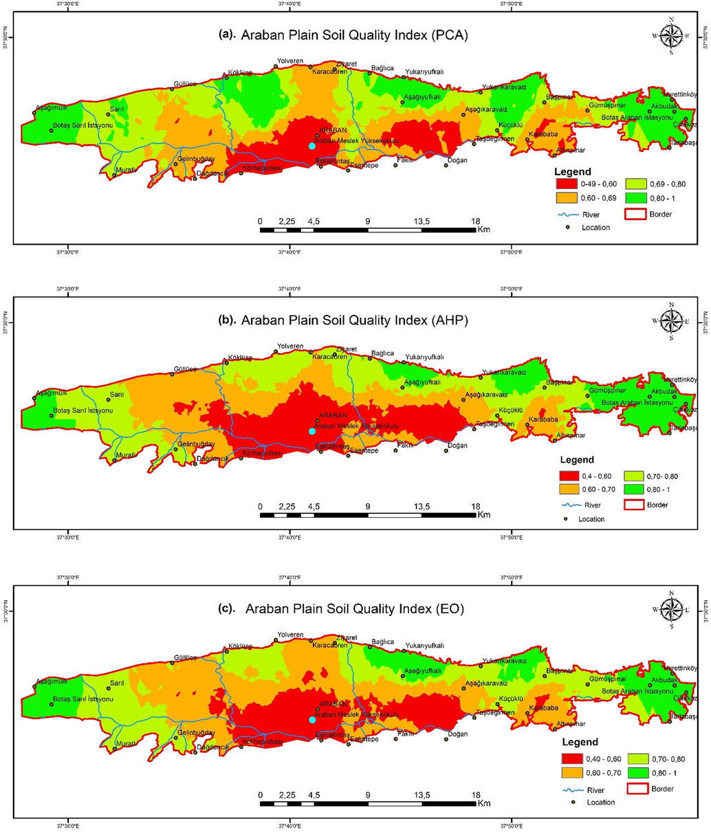
Spatial distribution map of soil quality index in the Araban plain generated by principal component analysis (a), analytic hierarchy process (b), and expert opinion (c).
The SQI values for the different land uses showed a significant relationship (P < 0.01) for all three methods. Pasture lands > orchard lands > arable lands quality classification results for all three methods were used to evaluate SQI values. These results show that land use type has a significant influence on soil quality. The highest (SQI-EO = 0.829) and the lowest (SQI-AHP = 0.552) soil quality score was obtained for pastureland and arable land, respectively (Fig. 3) (Table 6). SQI = soil quality index, PCA = principal component analysis, AHP = analytic hierarchy process, EO = expert opinion, the means followed by different letters are statistically different (p < 0.01) from each other.
Land Use
SQI-PCA
SQI-AHP
SQI-EO
Orchard
0.747 ± 0.08c
0.748 ± 0.08 a
0.770 ± 0.07c
Arable Land
0.679 ± 0.05b
0.552 ± 0.06b
0.692 ± 0.05b
Pastureland
0.823 ± 0.08 a
0.781 ± 0.08 a
0.829 ± 0.06 a
Significance
0.000
0.000
0.000
A minimum data set (MDS) was created using the soil quality indicators to determine the impact of land use types on SQI values. The SQI values varied significantly (P < 0.01) depending on the land use type (Table 6). The differences in the soil quality scores are due to the differences in the indicators determined by PCA and EO and the differences in the weighting values assigned to the indicators. The OM was identified as a key indicator influencing soil quality in all land use types by all assessment methods used in the study.
The ANOVA indicated that the assessment methods significantly differed from each other (P < 0.01). The PCA is a technique used to understand the variability structure of the dataset and to reduce the data dimension, but it is impossible to evaluate the indicators from an agricultural perspective. The AHP is a multi-criteria decision technique used in complex decision-making processes. The EO, on the other hand, is about analyzing and interpreting information provided by agricultural experts. In this case, it is assumed that the determination of soil quality by weighting the indicators with AHP provides a more accurate result after data reduction with PCA.
4 Discussion
Aggregate stability is a crucial indicator of soil degradation (Clergue et al., 2023), which was lower in orchards (30.9 %) compared to the agricultural fields (40.3 %). Typically, AS is lower in agricultural fields with extensive tillage, while it tends to be higher in orchards with fruit trees where tillage is reduced and surface vegetation is prominent (Duan et al., 2021). However, our results reveal a contrary trend. Most orchards in the Araban Plain are dominated by pistachio trees (85 %) planted on soil rows forming on alluvial fans and basalt plateaus along the slopes of the plain. Rainfed farming is prevalent in almost all fruit-growing areas (82 %), and herbicides use for weeds is limited, which facilitates tillage. This leads to consistently bare soil surface and increased soil structure disturbance during tillage. The lack of deep roots holding at 0–20 cm depth weakens aggregate formation. Additionally, intensive irrigation and fertilization practices are common in the agricultural fields of the Araban Plain, promoting plant growth, root development and enhanced aggregate formation. The higher AS observed in pastureland compared to both orchards and agricultural fields can be attributed to the continuous presence of surface vegetation and the support of root aggregate formation due to the lack of tillage. However, the lower bulk density in agricultural land compared to orchards results from more intense tillage, leading to greater soil compaction in agricultural land (Sun et al., 2023). The higher OM content in orchards compared to agricultural fields also supports this trend. Orchards typically employ a two-stage ploughing process, using a share plough and a cultivator, for weed control weeds and soil aeration. In contrast, agricultural fields experience more intensive vehicle traffic due to activities such as ploughing, loosening, pulverizing, levelling, planting, fertilizing, and spraying.
The high OM content in arable fields is attributed to residue incorporation into the soil and regular irrigation (Wilson and Xenopoulos, 2009), whereas no residue incorporation in orchards is responsible for low OM content. In addition, orchards are often situated on slopes without irrigation facilities in the study area, leading to surface runoff and wind erosion. Soil erosion results in agricultural land loss, reduced soil moisture, decreased microbial activity and declined OM (Punia and Bharti, 2023). This scenario supports the observed low OM and MBC content in the fruit growing areas of the Araban Plain. The presence of low soil compaction is also attributed to the accumulation of OM in the soil and limited vehicle traffic (Erdel and Barik, 2023). Grazing, a factor known to significantly increase soil compaction is not practiced intensively within the boundaries of the plain. This low level of grazing helps prevent soil compaction. On the other hand, the reason for the low phosphorus content in grazing areas is that phosphorus tends to remain immobile (Khadka et al. 2019) in the soil and is used as a nutrient in areas where agricultural activities are carried out.
The MBC serves as an indicator of the amount of carbon derived from microorganism biomass in the soil. Microorganisms play a crucial role in decomposing OM, facilitating nutrient cycling and contributing significantly to soil fertility. The highest average MBC was found on pastureland among three land use types. This disparity can be attributed to the minimal human intervention and high plant diversity. The absence of agricultural pesticides and fertilizers, along with limited agricultural activities and tillage on pasture, impacts on the habitats and activities of microorganisms, thereby supporting the maintenance of microbial activity.
In the PCA method, the data set to be created is firstly subjected to a test of sphericity Kaiser-Meyer-Olkin (KMO) (Field, 2000). For the data to be statistically significant and for the creation of a data set for each soil function using PCA, the KMO test factor should be > 0.7 (Solgi et al., 2017) or KMO factor > 0.5 (Field, 2000). In the assessment conducted with PCA, parameters are considered to be included in the data set if the Eigenvalue is > 1.0 for the PC (Mandal et al., 2008). Since the number of samples in pasture lands was insufficient in our study, they were evaluated in line with EO.
The PCA analysis indicated that different indicators are required for each land use to assess soil quality. However, EO suggests that a single data set that does not change depending on the type of land use would be more appropriate for the region being assessed and recommends the use of different weighting methods depending on the type of land use. The weighting of the indicators indicates the potential contribution ratio to the assessment of soil quality. Due to its contributes significantly to the ability of soils to form regular aggregates and to adsorb and release water and nutrient elements the OM indicator has the highest weighting for all land use types (Brejda et al., 2000; Budak et al., 2018).
The OM had the highest weighting coefficient in the SQI dataset according to the three methods. Organic carbon was found to be a sufficient factor for soil quality monitoring as it has significant effects on water holding capacity, aggregate formation, bulk density, soil pH buffering, pesticide uptake, soil aeration, infiltration capacity and soil biodiversity. This suggests that OM can be assessed as a key parameter limiting the functional potential of soils (Brejda et al., 2000; Budak et al., 2018). Brejda et al. (2000) identified the most important factors influencing soil formation as well as anthropogenic factors resulting from the different land use in the individual regions as reasons for the differences in soil quality between soils and geographical regions.
The lowest quality values (SQI-EO: 0.692, SQI-PCA: 0.679, SQI-AHP: 0.552) were determined for all three different SQI assessment methods on arable land. Intensive agricultural traffic and traditional tillage on arable lands lead to an increase in the mineralization rate in the soil. This leads to a decrease in organic matter content and insufficient aggregate formation (Bronick and Lal, 2005). Studies have shown that soils with high aggregation have a high organic carbon content (Han et al., 2010). In addition, aggregate stability decreases when grassland is converted to agricultural lands and increases when tillage is abandoned. In addition to the negative effects of the lack of organic matter, in the study area, a region where two crops are harvested, the use of agricultural machinery and equipment in tillage leads to a decrease in aggregate stability and a loss of the potential capabilities of the soil due to the transformation of macroaggregates into a smaller and less stable structure (Budak et al., 2018). The quality value of pasture was rated as high for each lands use according to all three methods. This indicates that land use has an influence on soil quality. It was also found that the differences between the individual land use types were statistically significant for the three different assessment methods (Table 6).
It was found that soil quality is low in regions with low OM, while high soil quality is observed in the regions with high OM contents. The OM is assigned the highest weight due to its crucial role in preserving soil fertility and mitigating soil degradation beyond erosion. Since PCA is used as a data reduction technique, some differences have emerged between PCA and EO. The difference arises from the parameters used for the two methods and the weights assigned to these parameters (Fig. 3).
Soil quality was significantly lower in areas where intensive agricultural activities are practiced compared to other regions. This indicates that the intensity of agricultural traffic and traditional tillage methods have a negative impact on soil quality. It is therefore necessary to apply modern agricultural techniques and sustainable cultivation methods to maintain and improve soil quality in agricultural areas. In addition, soil management strategies should be developed to increase OM content and the stability of macroaggregates in areas with intensive agriculture and low soil quality. This will help to boost the productivity of agricultural land and maintain soil quality (Fig. 3).
5 Conclusions
Three different methods (PCA, AHP and EO) were used to determine the soil quality of the Araban Plain. Organic matter, aggregate stability, bulk density and microbial carbon biomass can be considered as the most important parameters affecting soil quality. The AHP method proved better for assessing soil quality in Araban Plain and would be appropriate for assessing soil quality of similar regions. The 53.04 % of the soils were classified as low quality with a soil quality score of < 0.60 in the Araban Plain. Similarly, 39.57 % of the soils were classified as moderate quality, with a quality score between 0.60 and 0.80 (Fig. 3). Only 7.39 % of the study area was classified as high-quality soils with a quality score > 0.80. An improvement in soil quality is possible by increasing the organic matter content and aggregate stability of the soil. In addition, the reduction of agricultural traffic in the Araban Plain and the reduction of bulk density with a simultaneous increase in organic matter can improve soil quality.
Funding
This work was supported by Harran University-Scientific Research Coordination Unit under Project Numbers: HÜBAP-22197.
CRediT authorship contribution statement
Ömer Çelik: Writing – review & editing, Writing – original draft, Visualization, Software, Investigation, Formal analysis, Data curation. Abdulkadir Sürücü: Writing – review & editing, Validation, Supervision, Resources, Project administration, Methodology, Funding acquisition, Conceptualization.
Declaration of competing interest
The authors declare that they have no known competing financial interests or personal relationships that could have appeared to influence the work reported in this paper.
References
- Explaining the soil quality using different assessment techniques. Appl. Environ. Soil Sci.. 2023;2023
- [CrossRef] [Google Scholar]
- The soil management assessment framework. Soil Sci. Soc. Am. J.. 2004;68(6):1945-1962.
- [CrossRef] [Google Scholar]
- Blake, G.R., Hardge, K., 1986. Methods of Soil Analysis. Bulk Density, Part1. 2nd Ed. Agronomy 9. ASA and SSSA, Madison.
- Prioritising soil quality assessment through the screening of sites: The use of publicly collected data. Land Degrad. Dev.. 2014;25(3):251-266.
- [CrossRef] [Google Scholar]
- Identification of regional soil quality factors and indicators: I. Central and southern high plains. Soil Sci. Soc. Am. J.. 2000;64(6):2115-2124.
- [CrossRef] [Google Scholar]
- Soil quality assesment of upper tigris basin. Carpathian J. Earth Environ. Sci.. 2018;13(1):301-316.
- [Google Scholar]
- Assessment of soil quality in a heavily fragmented micro-landscape induced by gully erosion. Geoderma. 2023;431(February):116369
- [CrossRef] [Google Scholar]
- Estimating soil aggregate stability with infrared spectroscopy and pedotransfer functions. Soil Security. 2023;11(May 2022):100088
- [CrossRef] [Google Scholar]
- Land use conversion and lithology impacts soil aggregate stability in subtropical China. Geoderma. 2021;389(January):114953
- [CrossRef] [Google Scholar]
- Erdel, E., Barik, K., 2023. Effects of different soil management practices on some soil properties in a semi-arid region, Igdir, Turkey. J. Agric. Sci. Technol., 773–745.
- Key Aspects of Strategies for Sustainable Development of Drylands. Rome, Italy: FAO; 1993.
- Field, A., 2000. Discovering statistics using SPSS for windows sage publications.
- Gee, G.W., Bouder, J.W., 1986. Particle Size Analysis. İn: Clute, A. (Ed.), Methods of Soil Analysis. Part I Agronomy No: 9 Am Soc. of Agron.
- Indicators of soil quality and crop productivity assessment at a long-term experiment site in the lower Indo-Gangetic Plains.pdf. Soil Use Manag.. 2022;39(1):503-520.
- [CrossRef] [Google Scholar]
- Han, K.-H., Ha, S.-G., Jang, B.-C., 2010. Proc. of Int. Workshop on Evaluation and Sustainable Management of Soil Carbon Sequestration in Asian Countries Aggregate Stability and Soil Carbon Storage as Affected by Different Land Use Practices, 1996.
- IKTM, 2023. Gaziantep İl Kültür ve Turizm Müdürlüğü. https://gaziantep.ktb.gov.tr/TR-100441/araban.html adresinden erişildi.
- Isermayer, H., 1952. Eine Einfache Methode zur Bestimung Der Bodenatmııng und Der Karbonate in Boden. In 2. Pflanzener Nahr Bodenkd. (Issue 56).
- Kacar, B., 1994. Bitki ve Toprağın Kimyasal Analizleri III Toprak Analizleri. Ankara Üni. Zir. Fak. Eğitim Araştırma Geliştirme Vakfı Yayınları No.3.
- Kemper, W.D., R. C. R., 1986. Aggregate stability and size distribution. In: Methods of Soil Analysis, Part 4: Physical Methods, issue 9, pp. 317–328. Doi: 10.2136/sssabookser5.4.c14.
- Khadka, D. Lamichhane, S., Thapa, B., Sah, K., Gurung, S.B., Adhikari, B.N., et al., 2019. National Winter Crops Workshop. November, 672–686.
- Regenerative agriculture for food and climate. J. Soil Water Conserv.. 2020;75(5):123A-A124.
- [CrossRef] [Google Scholar]
- A functional evaluation of three indicator sets for assessing soil quality. Appl. Soil Ecol.. 2013;64:194-200.
- [Google Scholar]
- Evaluating impact of irrigation water quality on a calcareous clay soil using principal component analysis. Geoderma. 2008;144(1–2):189-197.
- [CrossRef] [Google Scholar]
- Comparison of soil quality index using three methods. PLoS One. 2014;9(8)
- [CrossRef] [Google Scholar]
- Soil quality assessment under different land use systems of Gandhi Krishi Vigyana Kendra, Bengaluru. ∼ 1517 ∼. Pharma Innov. J.. 2023;12(1):1517-1526.
- [Google Scholar]
- Nelson, D.W., Sommers, L., 1982. Methods of Soil Analysis, Part 2. Chemical and Microbiological Properties, Page, A.L., Miller, R.H. Keeney, D.R. (Ed) 2nd Ed. SSS of Am. Inc. Pub., Madison, Wisconsin.
- Phosphorus. In: Page A.L., ed. Methods of Soil Analysis, Part 2: Chemical and Microbiological Properties. Madison, WI, USA: ASA-SSSA; 1982.
- [Google Scholar]
- Loss of soil organic matter in the mining landscape and its implication to climate change. Arab. J. Geosci.. 2023;16(1)
- [CrossRef] [Google Scholar]
- Rawls, W.J., 1983. Estimating soil bulk density from particle size analysis and organic matter content. In: Soil Science, vol. 135, issue 2, pp. 123–125. Doi: 10.1097/00010694-198302000-00007.
- Rhoades, J., Chandavi, D., Lesch, S.F., 1999. Soil Salinity Assessment Methods and Interpretation of Electrical Conductivity Measurement FAO Irrigation and Drainage Paper 57 Rome.
- Soil quality assessment using multivariate approaches: A case study of the dakhla oasis arid lands. Land. 2021;10(10):1-22.
- [CrossRef] [Google Scholar]
- Improving SVR and ANFIS performance using wavelet transform and PCA algorithm for modeling and predicting biochemical oxygen demand (BOD) Ecohydrol. Hydrobiol.. 2017;17(2):164-175.
- [CrossRef] [Google Scholar]
- Soil compaction and maize root distribution under subsoiling tillage in a wheat-maize double cropping system. Agronomy. 2023;13(2):1-12.
- [CrossRef] [Google Scholar]
- Thomas, G.W., 1982. Methods of Soil Analysis, Part 2. Chemical and Microbiological Properties, In: Page, A.L., Miller, R.H. Keeney, D.R. (Eds.), 2nd ed. S.S.S. of America Inc. Publisher, Madison, Wisconsin.
- Tübitak, 2017. Türkiye Çölleşme Modeli Teknik Özet. http://www.cem.gov.tr/erozyon/Libraries/su/TEKNIK_OZET_TR.sflb.ashx Erişim 14. 06. 2018.
- Introduction: soil conditioners, soil quality and soil sustainability. In: Handbook of Soil Conditioners. CRC Press; 2020. p. :1-41.
- [Google Scholar]
- Evaluating indicators of land degradation in smallholder farming systems of western Kenya. Geoderma. 2013;195–196:192-200.
- [CrossRef] [Google Scholar]
- Effects of agricultural land use on the composition of fluvial dissolved organic matter. Nat. Geosci.. 2009;2(1):37-41.
- [CrossRef] [Google Scholar]
- An approach to improve soil quality: a case study of straw incorporation with a decomposer under full film-mulched ridge-furrow tillage on the semiarid Loess Plateau, China. J. Soil Sci. Plant Nutr.. 2020;20(1):125-138.
- [CrossRef] [Google Scholar]


