

Translate this page into:
A study on the cognition of the regional types of rural revitalization from the perspective of land planning
-
Received: ,
Accepted: ,
This article was originally published by Elsevier and was migrated to Scientific Scholar after the change of Publisher.
Peer review under responsibility of King Saud University.
Abstract
The overall land use planning is the basis for the implementation of the land use control system and the advance estimation of the future land use development trend. The smooth implementation of the planning will directly affect the direction and status of land use. Taking the preparation of rural land use planning as an example, this study realizes “one map” to control village development and planning through the scientific and rational use of planning methods and technologies. Guide the reasonable arrangement of various land use at the village level to make it consistent with the revitalization and development of the village, so as to put forward suggestions and Countermeasures for the preparation of village land use planning. Then, according to the specific actual situation of the countryside and making full use of the comparative analysis method and ecological service value analysis method, this paper makes a comprehensive qualitative and quantitative evaluation from the realization degree of planning control indicators, the protection of cultivated land and basic farmland, and the progress of spatial layout of construction land. The results show that cultivated land and basic farmland have been well protected, but due to the great potential of rural industrial and mining surplus indicators. In future construction projects, local modifications within the scope of the village can be appropriately carried out according to the construction needs of the project.
Keywords
Land planning
Rural vitalization
Farmland protection

1 Introductions
The general planning of land use is the general arrangement of land use in the future period (usually 15 years) from the perspective of time and space, according to the needs of national economic and social development, and following the relevant laws of natural, economic and social development (Barton et al., 2020). As a basic planning, the overall land use planning is the basis for the state to implement land use control, which covers all land space and is the basic planning in the national planning system (Williams, 2020). Through the scientific organization, utilization and management of land, we can improve the land utilization rate and output rate, so as to achieve the balance among economic, social and ecological benefits, and better protect land resources (Jankowski et al., 2019).
Rural development is closely linked with land, and rural land use planning is an effective part of land use planning system. Rural land use planning plays a key role in the implementation of rural revitalization strategy, which is conducive to better realize the beautiful rural construction and rural modernization (Zhu et al., 2019). The last level of land use planning system is rural land use planning. The implementation of planning directly affects the rural land use situation (Gangopadhyay et al., 2020). The current overall land use planning is divided into national, provincial, municipal, county and township levels. Although the existing overall land use planning at township level involves the arrangement of various land use activities in rural areas, the scale is small and the content arrangement is relatively rough (Markanday et al., 2019). Some areas need to further refine the contents and arrangements of the overall land use planning of villages and towns through the compilation of village land use planning, so as to more effectively regulate rural land use activities from the micro perspective (Wang and Cao, 2022). In order to better adapt to the needs of rural land use and management under the new situation, it is necessary to encourage the areas where conditions permit to work out the rural land use planning, fine management of rural land resources, and reasonable overall arrangement of rural land use activities (Shilewant et al., 2020).
Rural revitalization is a new task of rural development in the new era. It is a strategic upgrade based on the previous theory of rural development and construction, a full recognition of rural value and status, a change from “priority development of agriculture“ to “rural modernization development”, and an upgrade from “beautiful new rural construction“ to “rural revitalization” (Markiewicz, 2020). The rural revitalization strategy puts forward a new idea of urban–rural integration development, plans a new order of rural governance, and stabilizes the rural land contract relationship (Pan et al., 2021). It provides new impetus for increasing farmers' income, rural economic prosperity and rural ecological civilization. The implementation of rural revitalization strategy includes the revitalization of rural industry, rural construction, ecological environment protection, cultural revitalization and other work (Grochowska and Maecka, 2020). The key is to promote the coordinated development of rural production, life and ecology. Only with reasonable layout and scientific planning, can we promote the implementation of rural revitalization strategy step by step and target (Ramezanian and Hajipour, 2020). In particular, we should further create a new situation of beautiful countryside with the symbiosis and integration of production, life and ecology of different construction scales and different construction time sequence, so as to realize the comprehensive revitalization of the countryside (Hao et al., 2022). On the basis of respecting the original mountains, water and context of rural areas, we should inject new ideas into rural development and optimize the rural functional layout for the compilation and implementation of village level land use planning. It is one of the effective ways to realize the Rural Revitalization Strategy (Atumane and Cabral, 2021).
At present, rural land use and management are still faced with such problems as extensive and inefficient land use, scattered construction layout, lack of public facilities, and rural style degradation, which are not conducive to the implementation of rural revitalization strategy (Laari et al., 2019). The core measure to solve this problem is to make full use of the village level land use planning to optimize the allocation of land resources and coordinate the scale, structure, layout and time sequence of various types of land use (Felix et al., 2019). It can be said that the village level land use planning plays a fundamental role in the process of Rural Revitalization and development, is the basis of realizing the strategic measures of rural revitalization, and provides an important guarantee of land elements (Bodini et al., 2019). Carrying out village level land use planning not only opens a new era of “fine management“ for rural land, but also has profound significance for optimizing the structure and layout of rural land, strengthening the fine management of rural land use supply, and supporting and serving the implementation of rural revitalization strategy (Wang et al., 2022). Through the implementation of village level land use planning, the purpose of specific plots in the village area can be clarified, and all kinds of land use in the village can be registered and recorded, so that the competent departments and villagers can know that there is a land use account book (Tang and Zhu, 2020). Due to the current research on village level land use planning is relatively backward, there are many types of village level planning, overlapping projects, different focus of each planning, and lack of coordination and overall planning (Apostolopoulos et al., 2020). It really needs a village level land use planning to coordinate all kinds of special planning to specifically implement the land layout of these planning, so as to make it in line with the actual situation of grass-roots land and the desire of users to develop production, and further promote the healthy and sustainable development of new urbanization.
2 Related work
The application of system method, applied economics and policy science have become the important technical means to evaluate the planning scheme and its decision-making, which improves the rationality of the planning scheme, especially the content arranged; Kiryluk-Dryjska et al. (2020) think that the evaluation should be made from the environment and background of planning policy-making, the mechanism and procedure of planning implementation process, and the elements and conditions of planning results. Yanbo et al. (2021) have conducted a lot of empirical research. If the whole plan has a strict formulation and implementation process and good control and guidance standards, the consistency between the planning results and the design scheme will not become the only and final standard for the evaluation of the implementation effect of the plan. At present, researchers mostly use the combination of quantitative and qualitative methods to carry out the research on the implementation evaluation of the overall land use planning, and have made a lot of research results. Most of these studies evaluate the implementation of land use planning based on index system and related evaluation models. Kozera et al. (2021) evaluation system for the implementation of general land use planning is mainly composed of result evaluation, benefit evaluation and effectiveness evaluation. Through different quantitative models, the effect evaluation index and implementation evaluation index are established. The characteristic of the theory is simple and practical. Although the consideration is not comprehensive, it plays a positive role in evaluating the implementation of the plan and making decisions on the adjustment and revision of the plan. Wu Ci fang added the improved coordination degree model into the evaluation index system of the implementation of the overall land use planning, and achieved remarkable results in considering the comprehensive evaluation of multiple factors. However, it is difficult to determine the upper and lower limits of each evaluation factor in the model. Cook (2019) have made active exploration in designing and simplifying the index system and calculation model of implementation evaluation. Pérez-Calderón et al. (2020) deeply analyzed the basic concepts, characteristics, system structure and other key factors of the implementation evaluation of the overall land use planning, and developed the implementation evaluation support system of the overall land use planning based on the mathematical model and specific process.
3 Research methods
3.1 Compilation of land use planning in rural revitalization
(1) Planning procedure
The compilation process of village level land use planning is shown in Fig. 1, which can be divided into the following six steps. Preparatory work: including the organization of personnel, equipment and materials, funding support, data collection. Field investigation and research: collect basic data carefully and carry out the current situation of economic and social development of villages. Investigation and research on land resource utilization, land ownership, farmers' residential areas, village industry, public service demand, engineering construction and other aspects. Data analysis and research: according to the investigation and research and data collection, study and analyze the village land use, economic development, population development, ecological environment, social undertakings and other aspects. Plan design and preparation: around the goal and task of rural revitalization and development, carry out the analysis of land use supply and demand, optimize the layout of village land use according to local conditions, and combine with zoning guidance and control. We will make overall arrangements and adjustments to optimize land for production, living and ecological use, strengthen the protection of cultivated land and the management and protection of permanent basic farmland, and promote land consolidation in an orderly manner. Carry out planning demonstration: hold expert demonstration meeting for village land use planning compilation, invite relevant planning experts and local government industry authorities to discuss, study and demonstrate; Announcement of planning approval: after villagers' satisfaction and consent, it shall be submitted to governments at all levels and competent departments for approval step by step according to the procedures, and the approval results shall be publicized.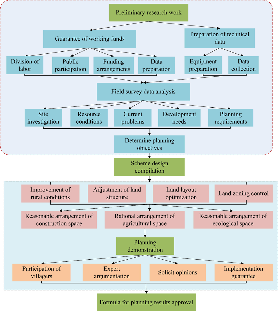
Preparation process of village level land use planning.
In the process of rural transformation and development constantly promoted by industry, the relationship between industry and village has evolved into the “synergistic symbiosis“ between industry and village from the drive of industry and the promotion of village. It can be seen that there are three main relationships in the integration of industry and village, namely the upgrading of rural industries, the synchronization of various functions and the integration of corresponding spaces.
(2) Reasonable planning and arrangement of construction space
The arrangement of homestead should be in strict accordance with the national policy of “one house for one household” and the standard of homestead area in various places, and reasonably determine the scale of land use in combination with the population scale and change trend of villages. On the basis of determining the scale of village homestead, optimize the layout, make full use of unused land in the village as much as possible, and facilitate the arrangement of land for public infrastructure. At the same time, the principles of beautiful living environment, convenient residents’ life, convenient agricultural production and reflecting local characteristics shall be taken into account. For villages with large population, concentration and active economy, homestead can be arranged in combination with road traffic and industrial structure layout, so as to give full play to the asset function of homestead.
(3) Rational planning and arrangement of agricultural space
Implement the responsibility system for cultivated land protection, take adhering to the strict observance of the red line of cultivated land as the most basic task of village land use planning, and focus on the delimitation and protection of permanent basic farmland. Village level land use planning mainly divides and defines permanent basic farmland protection area and general farmland in farmland protection. The basis of division is to investigate and evaluate the quality of cultivated land reserve resources first, and according to the results of agricultural land grading (Li et al., 2021). Based on the comprehensive analysis of the cultivated land fertility grade, slope, plot contiguous degree, and fully considering the industrial needs, villagers' willingness, ecological protection and other factors, the high-grade cultivated land is classified into the high-grade cultivated land.
(4) Reasonable planning and arrangement of ecological space
The most precious wealth of rural areas is its good ecological environment, which is the biggest advantage different from the reinforced concrete everywhere in cities and towns. The special ecological function of rural areas should be considered in the village level land use planning, and as an important content, the planning measures should be used to protect the rural ecological environment and optimize the layout of rural ecological space. In terms of layout, we should make orderly use of nature, adjust and optimize the structure, delimit the red line of agricultural space and ecological protection, and build a scientific and reasonable pattern of urbanization, agricultural development, ecological security and natural coastline. After the ecological space layout planning is determined, it should be strictly controlled according to the ecological space use zoning, and it is forbidden to change into construction space and agricultural space. On the basis of restoration and control, in view of the problems of soil and water loss, desertification and rocky desertification in the village, we should make an overall plan, promote comprehensive treatment, carry out the reclamation of damaged land, protect and improve the ecological environment and protect green villages.
3.2 Traffic demand forecasting method for land use
(1) Traffic occurrence
Traffic demand is a function of land use, the total traffic demand generated by a piece of land is a certain time, usually the number of people or vehicles generated and attracted by the land within a day. The size of traffic production is closely related to the nature of land and the scale or intensity of activities on the land. The residents travel for a certain purpose and lead to the production of traffic. Traffic is not an end, but a process in which the residents achieve a certain purpose. The individual characteristics, residential location (accessibility) and social development level are all factors that affect the occurrence of residents' travel. The purpose of residents' travel is simplified to work, school, shopping and entertainment, and the model is calibrated according to the survey results of relevant residents' travel. The model is in the form of:
(2) Traffic attraction model
Traffic attraction refers to the travel attracted by the end point in people's travel activities. The intensity of traffic attraction varies with regional location, land use nature, travel distance and travel purpose. Different land use properties have different attraction intensity. It is assumed in this plan that jobs on industrial land, commercial land, administrative office land and residential land attract work travel; The number of school Posts attracts students to travel to school; Commercial land attracts people to travel for shopping and entertainment purposes; Administrative public buildings and residential land attract travel for other purposes.
Based on the above assumptions, a classified land use attraction right model is established in the form of:
(3) Trip generation model
According to the socio-economic situation of the planning year and the current socio-economic situation of the planning area, the per capita number of trips in the planning year can be predicted on the basis of the current per capita number of trips, and then the total number of trips in the planning year can be calculated according to the total population in the planning year of the planning area.
(4) Trip generation model
3.3 Ecosystem service value analysis method
Ecosystem service value analysis method is a common and important analysis method for scientific management of ecological land (Li et al., 2017). Through analysis and comparison, the equivalent table of ecosystem service value per unit area of terrestrial ecosystem has high credibility, This table can be used to calculate the coefficient values of ecosystem types and ecological values corresponding to land use types. The ecological service value formula of various land use types is calculated by using the ecological value coefficient.
3.4 Fuzzy cognitive graph learning algorithm
The key to the fuzzy cognitive graph learning is to find the optimal weight matrix of the target iteratively by using the known data according to the search strategy of the algorithm, so as to build a more accurate fuzzy cognitive graph model (Yuan et al., 2021). Therefore, the learning algorithm is very important for the construction of fuzzy cognitive graph.
Hebbian rules is an unsupervised technique originally applied to artificial neural network training. The main feature of this learning rule is that if two neurons, one of which activates the other, are repeatedly and continuously activated, then the value of the connection between them should be strengthened. That is, if two units have similar activation values, then their connection values will continue to strengthen as the connection between them. The mathematical formula for weight change is as follows:
The initial structure of the fuzzy cognitive map is determined by the expert knowledge, and the determination of the initial weight value will have a great impact on the final FCM performance. For the application areas where it is difficult to give expert knowledge, evolutionary algorithms can be used to update the weight matrix by learning the rules of historical data.
4 Research on the implementation evaluation of rural land planning
4.1 Evaluation of realization degree of planning control indicators
Taking village A as an example, village A has convenient transportation and superior location conditions. The railway runs through the north and south, the national and provincial roads meet in the whole town and connect with the high-speed kilometers in the town, and the highway covers the whole town 100 %, forming a very developed land transportation network; Land and water transportation crisscross, forming a transportation network extending in all directions, providing a good transportation environment for the economic development of villages and towns. Fig. 2 shows the geographical location of village A.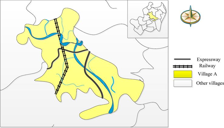
Geographical location of village A.
In order to ensure the objectivity, comprehensiveness and rationality of the planning implementation evaluation, according to the situation of the small town and based on the research results at home and abroad, the main control indicators are selected for evaluation. The appraisal scope covers all the land within the jurisdiction, and the appraisal period is 2005–2025.
4.2 Realization degree of binding indicators
In the current plan, by 2025, the amount of cultivated land in rural a will not be less than 285.25 ha. By the end of 2020, rural a has 389.65 ha of cultivated land, 104.4 ha more than the planning target. In the current plan, the protected area of rural a basic farmland shall not be less than 198.22 ha from 2005 to 2025. By the end of 2020, village a has 205.25 ha of basic farmland, 7.3 ha more than the planning target. The basic farmland protection tasks assigned by the superior planning have been implemented, and the basic farmland protection area has fully met the requirements of the planning target. It is planned that by 2025, the scale of urban and rural construction land will be controlled within 1356.25 ha. By the end of 2020, the actual urban and rural construction land scale of village a is 585.25 ha, 771 ha less than the current planning, as shown in Fig. 3.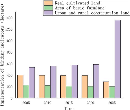
The realization degree of rural A binding index.
4.3 Realization degree of expected indicators
It is planned that by 2025, the total scale of rural a construction land will be controlled within 1287.22 ha. By the end of 2020, the total construction land of village a will be 780.42 ha, 806.80 ha less than the planning target. It is planned that the scale of rural industrial and mining land will be controlled within 1266.56 ha by 2025. By the end of 2020, the scale of urban industrial and mining land in village a will be 675.45 ha, 591.11 ha less than the planning target. It is planned that by 2025, the scale of new construction land in village a will be controlled within 956.34 ha. In 2020, 146.77 ha of construction land will be added in village a, and the implementation speed of the plan is lower than that of the current plan. It is planned that by 2025, the scale of agricultural land occupied by new construction land in village a will be controlled within 855.36 ha. In 2020, rural a will actually add 125.66 ha of construction land, and the implementation speed of the plan is lower than that of the current plan, as shown in Fig. 4.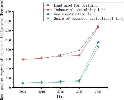
The realization degree of rural A expected indicators.
4.4 Assessment of farmland and basic farmland protection
In 2005, the cultivated land of village a was 402.46 ha. According to the special account for agricultural land of village a, the cultivated land of village a decreased year by year. From 2005 to 2020, the cultivated land of village a decreased by 22.81 ha due to the occupation of construction land, of which 8.77 ha were used for traffic and water conservancy projects, 6.73 ha for industrial construction projects, and 2.53 ha for public infrastructure projects, 1.36 ha are used for commercial service construction projects and 3.42 ha are used for residential construction projects. By 2020, the cultivated land area of the whole town will be 379.65 ha, as shown in Fig. 5.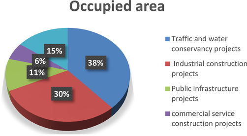
Annual decrease of cultivated land in rural A.
5 Empirical study on village level land use planning
5.1 Land use status
(1) Current situation characteristics
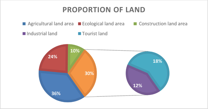
Taking village B as an example, the survey results of land use change in 2020 show that the agricultural land area of village B is 256.44 ha; The ecological land area is 167.22 ha; The construction land area is 67.89 ha; 88.87 ha of tourist land; Industrial land is 126.55 ha. In the land use structure of Village B, the proportion of agricultural land and ecological land is relatively close, the proportion of construction land is small, and the distribution of land use types is uneven, as shown in Fig. 6.
(2) Current problems
- Status of rural B land structure utilization.
From the analysis of the current land use situation of rural B, there are the following main problems: the number of cultivated land is small, the reserve resources of cultivated land are scarce, and the cultivated land area of the whole village accounts for only 13.7 % of the total land area. The development of reserve cultivated land resources can be strengthened through land consolidation and reclamation. The consolidation of construction land needs to be strengthened. There is a large demand for funds for rural residential consolidation, and it is difficult to promote rural residential consolidation on a large scale. The efficiency of land use and the degree of economical and intensive use can be improved by promoting the centralized and continuous construction of rural residential areas. The basic security work still needs to be improved. The traffic in the village is underdeveloped and it is difficult to communicate with the outside world; In the future, there is still a lot of room for improvement in the village's basic security work. We can strengthen the construction of basic public service facilities in the village in combination with the construction of beautiful villages.
5.2 Land use structure adjustment
(1) Overall structural adjustment
After optimization and adjustment, the overall land use structure of village B will be relatively stable by 2033 (Fig. 7). The agricultural land area of the whole village is 282.68 ha, accounting for 38.38 % of the total land area, 0.48 % lower than that in 2018; The total construction land of the whole village was adjusted to 28.06 ha, accounting for 4.12 % of the total land area, an increase of 0.48 % over 2018; The ecological land area of the whole village remains unchanged.
(2) Planning functional zoning
- Land use planning of village B.
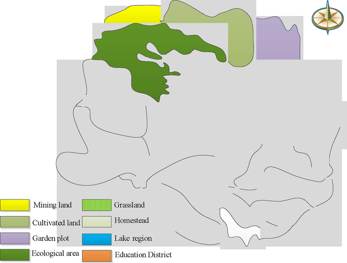
According to the planned land type of village C, from the perspective of urban planning, the village is divided into five functional areas: ecological restoration area, living and residential area, ecological forest area, landscape sightseeing area and agricultural and forestry planting area (see Fig. 8).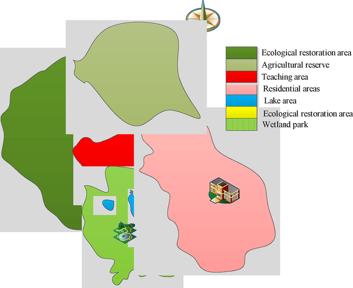
Functional distribution of village C.
Rural B development should first ensure the protection of ecological trees and basic farmland. On this basis: in the near future (1–5 years), enhance the satisfaction and happiness of living, that is, the construction of public service facilities, the organization of activities and the convenience of road transportation; In the medium term (5–10 years), develop the landscape tourism industry and increase the vitality and vitality of the village; In the long term (10–15 years), it will take time for the ecosystem to achieve balance, and mine greening requires patience and efforts. The above development time series are roughly long, and specific projects are arranged. If the time is ripe, it can be developed at the same time or cross.
6 Conclusion
The overall land use planning is the basis of the land use control system in China, and it is a pre estimate of the future land use development trend. The smooth implementation of the plan will directly affect the direction and status of land use. Optimizing the allocation of land resources plays an irreplaceable role in the implementation of rural revitalization strategy. It is necessary to make full use of the micro scale of village land use planning to optimize the allocation of land resources, so as to coordinate the scale, structure, distribution and timing of land use in various rural industries. At present, the planning of rural land use is in its infancy. The rural land use and management are still facing the problems of extensive and inefficient land use, scattered construction and distribution, lack of public facilities and degradation of rural style, which is not conducive to the implementation of the strategy of Rural Revitalization. Through the analysis of the implementation of the main rural planning indicators. The results show that: (1) both the rural a farmland and the basic farmland have reached the planning goal, which shows that the land and basic farmland in the village are well protected. (2) According to the total index of construction land, the scale of construction land, the scale of urban and rural construction land and the scale of urban and rural industrial and mining land are 53.51 %, 46.29 % and 38.68 % respectively, which have not highlighted the planning objectives. (3) The implementation of new construction land is low, only 15.53 %. The main reason for this phenomenon may be the relatively backward production conditions in rural areas, and it is difficult to get effective support from policies and funds. We should promote the further decoupling of economic growth and construction land by reasonably formulating the long-term goal of economic growth, adjusting the economic structure with advanced manufacturing industry and modern service industry as the breakthrough point, reducing the consumption of construction land resources for economic development, innovating the management mode of construction land and improving the control effect of construction land.
Acknowledgement
The authors are thankful to the higher authorities for the facilities provided.
Authors’ contribution
This study was done by the authors named in this article, and the authors accept all liabilities resulting from claims which relate to this article and its contents.
Funding
This research was supported by the China Postdoctoral Science Foundation Grant No. 69, grant , No. 2021M692009 2021 National Social Science Fund Annual Project "Research on Practical Logic and Innovation Path of Digital Rural Library Construction" (21BXW017).
Declaration of Competing Interest
The authors declare that they have no known competing financial interests or personal relationships that could have appeared to influence the work reported in this paper.
References
- The role of the expert knowledge broker in rural development: Renewable energy funding decisions in Greece. J. Rural. Stud.. 2020;78:96-106.
- [CrossRef] [Google Scholar]
- Integration of ecosystem services into land use planning in mozambique. Ecosyst. People.. 2021;17(1):165-177.
- [CrossRef] [Google Scholar]
- Human appropriated net primary productivity as a metric for land use planning: a case study in the US Great Lakes region. Landsc. Ecol.. 2020;35(6):1323-1339.
- [CrossRef] [Google Scholar]
- Rural development programs' impact on environment: An ex-post evaluation of organic faming. Land Use Policy. 2019;85:454-462.
- [CrossRef] [Google Scholar]
- Organic rural development: Barriers to value in the quest for qualities in Jordanian olive oil. J. Rural Stud.. 2019;69:106-116.
- [CrossRef] [Google Scholar]
- Land use planning for Coimbatore District (Tamil Nadu) Using priority based fuzzy goal programming model. Agric. Res. J.. 2019;56(1):146.
- [CrossRef] [Google Scholar]
- Soil Nutrient Information System (SNIS) in Middle Indo-Gangetic Plain of Bihar, India -A Tool for Land Use Planning. J. Indian Soc. Soil Sci.. 2020;68(1):25-33.
- [CrossRef] [Google Scholar]
- Potential conflicts in the land-use planning process: A case study of the rural commune of Olenica (Poland) Quaest. Geogr.. 2020;39(2):129-137.
- [CrossRef] [Google Scholar]
- Research on spatial optimization level strategy of beijing historical blocks based on tourists' cognitive evaluation. J. Landscape Res.. 2022;14(1):14-20.
- [CrossRef] [Google Scholar]
- Evaluating the scalability of public participation in urban land use planning: A comparison of Geoweb methods with face-to-face meetings. Environ. Plan.. 2019;46(3):511-533.
- [CrossRef] [Google Scholar]
- Local determinants of the Common Agricultural Policy rural development funds' distribution in Poland and their spatial implications. J. Rural Stud.. 2020;74:201-209.
- [CrossRef] [Google Scholar]
- Role of Local Investments in Creating Rural Development in Poland. Energies. 2021;14(1448):1-30.
- [CrossRef] [Google Scholar]
- Urban land use planning and its effects on the provision of public sanitation facilities in the Wa Municipality, Ghana. J. Geogr. Reg. Plann.. 2019;12(4):60-75.
- [CrossRef] [Google Scholar]
- Spatiotemporal dynamic analysis of forest ecosystem services using “big data”: A case study of Anhui province, central-eastern China. J. Clean. Prod.. 2017;142:589-599.
- [CrossRef] [Google Scholar]
- Economic, energy and environmental consequences of shifting from maize-wheat to forage rotation in the North China Plain. J. Clean. Prod.. 2021;328:129670
- [CrossRef] [Google Scholar]
- Determining discount rates for the evaluation of natural assets in land-use planning: An application of the Equivalency Principle. J. Clean Prod.. 2019;230(SEP.1):672-684.
- [CrossRef] [Google Scholar]
- A researcher's view on the proposal of legal regulations regarding major accident hazard assessment in the land use planning process in Poland. Geomat. Environ. Eng.. 2020;14(3):41-61.
- [CrossRef] [Google Scholar]
- Practical efficient regional land-use planning using constrained multi-objective genetic algorithm optimization. Int. J. Geo-Inf.. 2021;10(2):100.
- [CrossRef] [Google Scholar]
- Perception of Sustainability of Spanish National Parks: Public Use, Tourism and Rural Development. Sustainability.. 2020;12(4):1333.
- [CrossRef] [Google Scholar]
- Integrated framework of system dynamics and meta-heuristic for multi-objective land use planning problem. Landsc. Ecol. Eng.. 2020;16(2):113-133.
- [CrossRef] [Google Scholar]
- Taxonomic classification, characterization and mapping of BSP Farm of Parbhani for rational land use planning. Int. J. Curr. Microbiol. Appl. Sci.. 2020;9(4):2808-2826.
- [CrossRef] [Google Scholar]
- Informality and rural industry: Rethinking the impacts of E-Commerce on rural development in China. J. Rural. Stud.. 2020;75:20-29.
- [CrossRef] [Google Scholar]
- Land Use Transition and Eco-Environmental Effects in Karst Mountain Area Based on Production-Living-Ecological Space: A Case Study of Longlin Multinational Autonomous County, Southwest China. Int J Environ Res Public Health.. 2022 Jun 21;19(13):7587.
- [CrossRef] [Google Scholar]
- Village evaluation and classification guidance of a county in southeast Gansu based on the rural revitalization strategy. Land. 2022;11(6):857.
- [CrossRef] [Google Scholar]
- The influence of statutory land use planning on water sensitive urban design practices. Australas J. Water Resour.. 2020;24(11):1-13.
- [CrossRef] [Google Scholar]
- How does the rural settlement transition contribute to shaping sustainable rural development? Evidence from Shandong, China. J. Rural Stud.. 2021;82(22):279-293.
- [CrossRef] [Google Scholar]
- A review of deep learning methods for semantic segmentation of remote sensing imagery. Expert Syst. Appl.. 2021;169:114417
- [CrossRef] [Google Scholar]
- Study of Multiple Land Use Planning Based on the Coordinated Development of Wetland Farmland: A Case Study of Fuyuan City, China. Sustainability.. 2019;11(1):271.
- [CrossRef] [Google Scholar]


