

Landscape planning and design and visual evaluation for landscape protection of geological environment
⁎Corresponding author at: Art College of Xi'an University of Architecture and Technology, No. 13, Yanta Road, Xi'an, Shaanxi 710055, China. liurui20719@163.com (Rui Liu) 495641042@qq.com (Rui Liu)
-
Received: ,
Accepted: ,
This article was originally published by Elsevier and was migrated to Scientific Scholar after the change of Publisher.
Peer review under responsibility of King Saud University.
Abstract
As an important carrier of science education, ecological landscape development and regional ecological civilization construction, the quality of geological landscape resources has a direct impact on its landscape charm, and the protection of landscape resources is directly related to its sustainable development ability and regional ecological civilization construction. To avoid or reduce the negative impact of architecture on the environment, the development of architectural landscape based on the perspective of geology and ecology is the top priority of healthy and sustainable development. In this paper, the visual sensitivity of the landscape was assessed by GIS (Geographic Information System, GIS) software technology, by calculating and analyzing the relative slope of the terrain, and visualizing the results through visual sensitivity classification. Based on summarizing and analyzing the previous research results, this paper expounds the geological landscape system and resource system, and introduces the architectural landscape features of environmental landscape protection. Combined with the geological environment planning architectural landscape, the concept of architectural planning and landscape design is integrated, the architectural landscape based on geological environment protection is constructed, and the spatial organization and layout of buildings in the environmental landscape is planned. Finally, landscape visual sensitivity was evaluated based on GIS. The research results show that the architectural landscape and geological environment protected by geological environment landscape can be organically combined, and the landscape has strong visual attraction. The research results of this paper solve the conflict between architecture and geological ecology and provide scientific basis for environmental landscape protection of geological ecology. The composite score of visual sensitivity was obtained by GIS calculation. The most visually sensitive place ranked 25th, while the most visually sensitive place ranked 13th.
Keywords
Geological environment landscape
Architectural landscape planning
Landscape planning and design
Visual evaluation of landscape

1 Introduction
The characteristic elements of architecture are not the same due to different regions. The architecture in each region has its own characteristic elements. Architectural landscape as a unique form of language is a spirit and natural beauty of the transmission. From the longitudinal comparison of the north and south, from the coast to the inland, the characteristic elements of the architectural landscape are different, but they are essentially a regional reflection of the Chinese culture (Cetin, 2015). Architectural landscape is a kind of architectural landscape design based on service function. Any architectural landscape design can better reflect their value only when it reflects its regional cultural characteristics and meets people's functional needs. It is said that its characteristic elements are also special symbols generated for the regional culture of the region, and only by extracting these symbolic elements and applying them to the architectural landscape design can design elements with special significance be formed. This means that when analyzing architectural landscape design elements, we can accurately locate the corresponding cultural value and spiritual connotation, so that people can feel the special emotion that this characteristic element wants to express, and express the new value element.
When the comprehensive utilization of space environment becomes the main theme of architectural planning and design, ecological planning, and design factors, which are completely opposite to architectural planning and design, need to be integrated into architectural planning and design, and architectural planning and ecological design naturally become the mainstream thought of architectural planning (Antrop, 2018). Designers integrate the concept of “ecology” into architectural planning and design, but the specific architectural planning and design scheme does not really regard ecology and ecological balance as the main content of architectural planning. Many designers' architectural planning concept is changing quietly. At the beginning of the whole architectural planning and design, they fully consider the new idea of “harmonious coexistence of man and nature” in the process of comprehensive utilization of land resources. Architectural design is a manifestation of spatial effect. When the resources consumed in architectural planning and ecological design cannot be supplemented by space alone, it is necessary to ensure that the effect generated can be close to or greater than the original design state of architectural planning. In architectural planning and design, the atmosphere of architectural space effect and ecological space effect must be highly recognized by users, then it can be concluded that the design scheme of architectural planning and ecological environment is successful, otherwise it is still a waste of social resources. This kind of waste in architectural planning and design, its adverse signs must be checked in time, otherwise it is bound to lead to the waste of land resources, thus directly affecting the speed, level, and overall quality of urban construction (Curovic et al., 2019). Therefore, the ecological concept of architectural planning reflects its architectural value to a large extent.
With the development of information technology, some new technologies have also been applied to landscape evaluation, and GIS technology has been used to evaluate landscape suitability (Cetin et al., 2018). Discussed the concept of landscape, made a preliminary exploration of landscape evaluation methods and natural landscape resource management system, introduced foreign landscape evaluation schools and methods, and proposed the basic framework of management system (Cialdea, 2021).Uses virtual reality technology to present the coastal landscape with three-dimensional images, and uses VR technology to enable people to directly evaluate the landscape (Knight and Therivel, 2017). Based on the VMS (Virtual Management System) and VRM (Vendor relationship management) systems, Established the landscape visual environment management system along the Qinghai-Tibet Railway, and quantitatively evaluated the visual impact that railway construction projects may bring to the plateau landscape (Picuno et al., 2019). Landscape visual sensitivity evaluation is a measure of the attention degree of the landscape by the viewers. It reflects the attention degree and importance of the landscape, and reflects the relationship between the landscape and people. The higher the sensitivity of the landscape, the greater the attention of the viewers, the greater the impact of landscape changes on the viewers, and the stronger the response of the viewers. This paper constructs a landscape planning and design and visual evaluation system based on landscape protection of geological environment with the help of GIS software. The algorithm can produce visual sensitivity results more quickly and accurately, and provides new ideas for the accounting method, which has the value and significance of research.
2 Landscape ecosystems and resource systems
2.1 Landscape ecosystem
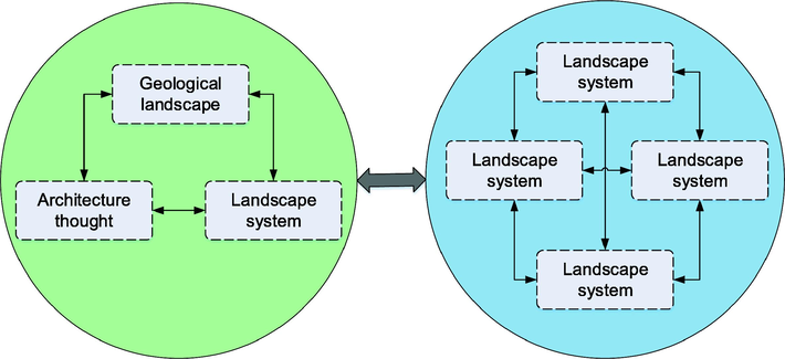
The geological environment and its habitat combine to form an ecosystem, and the ecosystem and geological environment combine to form a landscape or landscape ecosystem. Landscape ecosystem is a regional complex characterized by integrity and a functional unity of natural and human elements in different parts of the earth surface. Because the nature of landscape is a regional complex, landscape can also be called landscape ecosystem. The landscape ecosystem structure has two kinds of structures. One is the internal structure, which reflects the interrelationship among the components of individual units. The second is the external structure, which reflects the spatial combination or Mosaic state between units. Among them, the internal structure can be divided into element structure (the combination order and representation of various elements in the unit, such as terrain, climate, soil, vegetation, hydrology, and land use) and element structure (the higher-level individual unit is the spatial Mosaic total of several lower-level individual units) (Martinez-Grana et al., 2017). Just because of this structural relationship, the landscape ecosystem has a significant hierarchical differentiation law. Geological landscape resources system and environment can form a larger scale, higher hierarchy system, namely the geological landscape resources - environment system is shown in Fig. 1, the system of natural areas or land space, according to landscape ecology, geological landscape resources system, landscape resources - or the whole geological environment system is regarded as different hierarchy of landscape ecological system.
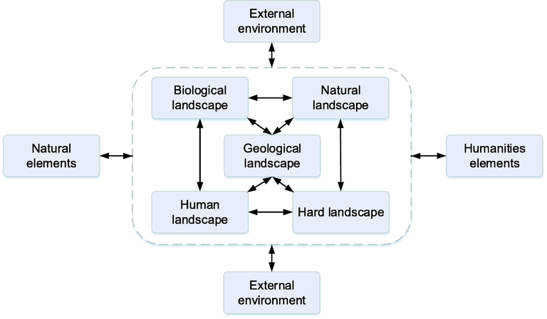
- Geological landscape resource - environment system map.
2.2 Architectural landscape features
In the landscape construction of architecture, nature and the surrounding environment are given priority, and the overall coordination with the natural landscape is emphasized to create a landscape type with harmonious coexistence of architecture and environment. For architecture, it is a more reasonable way of existence. Through integration and reconstruction, it forms a continuous spatial system of the earth, architectural concept and landscape system. The scattered arrangement of architectural landscape makes the landscape with strong terrain perception, vision penetration, spatial hierarchy and overall harmony, forming a picturesque ornamental landscape. Because of its unique characteristics, this kind of landscape is different from other landscape types and shows unique landscape characteristics. In the design of its form, consider how to effectively coordinate the building and the environment, based on the environment and into the environment. The schematic diagram of architectural landscape features is shown in Fig. 2.
-
(1)
Ecology
- Schematic diagram of the relationship of architectural landscape features.
Before the building was completed, it was considered to combine with the local ecology, and the main body of the building was hidden in the soil or natural materials in combination with the local climate environment, so that its form could be coordinated with the surrounding terrain environment (Sante et al., 2019). At the same time, the damage to the natural environment and the living environment of animals and plants will be minimized during the design and construction. These elements create a landscape atmosphere in harmony with the environment and the building, reflecting the original ecological design philosophy. In the language of architectural construction, returning to simplicity makes natural beauty and artificial beauty perfectly combined.
-
(2)
Humanity
Architecture is built and applied in modern society to meet the needs of human survival and use. The landscape formed by it and the surrounding terrain environment is the supplement of human activities to the natural environment, and it is designed and served for human beings. It is the display of the history, culture, and art of a region, as well as the art and culture of an era. It has the cultural connotation and historical significance of humanistic landscape.
-
(3)
Landscape
Landscape architecture has become the trend of architectural design in today's world. It makes use of the landscape features of architectural landscape to realize the high integration and unification of geology and architecture, as well as architecture and environment (Ha and Yang, 2019). The type of building space is particularly complex, with entrances and exits inconsistent with the environment and rigid. By taking advantage of the landscape features of the building's landscape, the vertical spatial connection between the building and the ground landscape is coordinated to achieve a high-quality integration.
-
(4)
Systematic
In the landscape design, the ecology, humanity, and landscape of architecture form an effective and continuous unity, which constitutes the systematic characteristics of the whole rural landscape. In design, the designer takes landscape and architecture, integrates architecture with ecology, culture, and environmental landscape, and forms an integrated design of landscape and architecture.
2.3 Environmental landscape resource system
In a certain range, landscape resources of different types, different units are not isolated, but interrelated depend on each other, they together into one with a particular structure and function of organic whole, this is the landscape resources system, generally by the natural landscape and cultural landscape resources of two sub-systems. For the whole landscape resource system, each subsystem is its constituent element, and each subsystem is composed of several sub-subsystems or elements, and each sub-subsystem or element is composed of several sub-subsystems or elements. The landscape resource system has new functions or characteristics for its various elements. For example, mountains, minerals, rocks, structures, rivers, lakes, etc. as elements of the landscape resource system, if viewed in isolation, are only geological terms, but through coordination and combination, they become a landscape resource complex with aesthetic characteristics, ornamental value and development and utilization value, namely, landscape resource system. The landscape resource system is in a certain external environment. If the landscape resource system is the main body, then all the things and factors surrounding the system are the environment of the system. The landscape resource system does not exist in isolation, but is interrelated and integrated with the external environment. Therefore, the landscape resource system and the external environment can form a larger and higher-level system, namely the landscape resource-environment system. According to landscape ecology, landscape resource system, landscape resource-environment system and the whole region can be regarded as different levels of landscape ecosystem. The environmental landscape resource system is shown in Fig. 3.
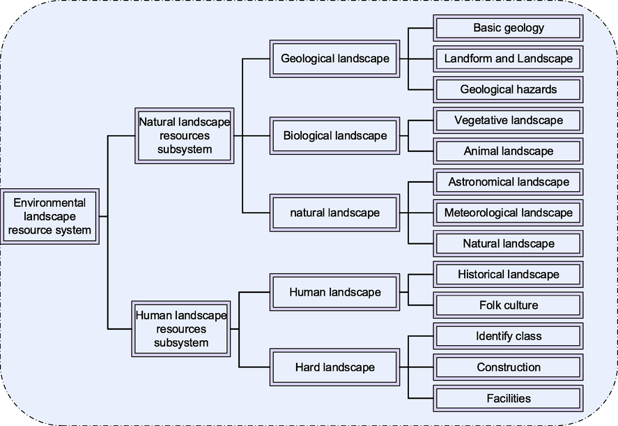
- Environment landscape resource system map.
3 Geologic environment landscape protection architecture landscape planning and design
3.1 Plan the architectural landscape according to the geological environment
The co-configuration architectural form of the interaction between architecture and environment emphasizes the simultaneous presentation of the topography and architectural features of the mountain slope, so that architecture and environment complement each other and can borrow from each other (Arcidiacono et al., 2016). The fusion type adopts the adaptive approach, which emphasizes the original topography and topography of the large scale slope, combining the building with an intimate, modest attitude and scale in the lot. Architecture is connected with nature: the design of modern architecture is combined with landscape environment design. Natural landscape elements must be used as a background to simulate, refine and integrate the surrounding environment. At the same time, throughout the layout, the building should reflect the surrounding topography and landscape elements, find a fusion point with the landscape, and make the building an organic part of the landscape.
In modern architectural design, in order to weaken the presence of buildings in nature, minimize the negative impact of buildings and human activities on the ecological environment, and restore the most original state of nature (Sacchini et al., 2018). It has become a design trend for many architectural designers to hide buildings in the natural environment. Most of the building volume is hidden in the natural environment through covering or other natural means by means of concealing the building volume. It eliminates the artificial imprint and strengthens the connection between the building and the surrounding environment, which is also the most direct method of the hidden operation of the building volume, in order to create a building form with topographic and meteorological features, and to restore the natural texture to the greatest extent. The design technique of hiding buildings in nature, from the appearance of the continuation of the natural landscape, so that people ignore the existence of buildings.
3.2 Optimization of geological form
In order to optimize the original terrain environment, the building uses its morphological characteristics to build, which is an opportunity to transform the original terrain, so the building can take the initiative to optimize the original terrain environment. Firstly, through the analysis of the original natural space structure, the extension trend of the earth-covered building volume is controlled, the shape and color are adjusted, and the relationship between the drawing and the bottom is strengthened. Second, strengthen the pattern and trend of the natural landscape pattern, and use buildings as supplements to realize the complete situation of the landscape pattern. Third, create a good environment, and realize the restoration and improvement of the natural conditions of the site and green vegetation.
3.3 Integration of architectural planning and landscape design concepts
In the architectural landscape design, the site features such as natural landscape pattern, topography and landform are taken as the basis, which does not destroy the overall characteristics of the environment, but can create space and form beauty to reflect the interaction between inside and outside the building. According to the distinctive features of the original site environment, the design method of subtraction and the simple and pure maintenance structure were adopted to achieve the effect of co-construction. In addition, the natural elements were taken into account, and the integration of architecture, environment and people was obtained from the landscape pattern, natural situation and the unity of internal and external scenes (Cetin et al., 2018). For example, for the mountainous terrain, in order to make the natural form of the environment more complete and strengthen the trend, the building is inserted into the landmark to supplement the site to continue the trend of the inclined slope. Or it can play a gestalt role on the mountain through the building form conforming to the surface scale of the contour line.
The main purpose of the space construction is to realize the adaptation and integration of the spatial structure relationship between the two, so that the building can conform to the terrain and other natural conditions as far as possible. The continuation of the landscape space of the building is to minimize the transformation of the original ecological landscape space in the countryside, and to enhance and modify the features of the site through the integration of the surrounding space. The mulch planting design integrates the building with the rural landscape and continues the rural landscape.
3.4 Integration of architectural planning and landscape design concepts
Because of the disadvantages of architecture itself, it is necessary to consider the beneficial way in the site selection and layout of architecture. Such as sloping buildings, should be placed in the windward side of the slope, the relative position of the higher ridge; Try to make the inlet and outlet of the building conform to the dominant wind direction, increase the air pressure difference, and enhance the ventilation effect of the building.
The building's own form determines that its architectural temperament tends to show a relatively low-key and implicit posture. From the perspective of architectural aesthetics, its form is a horizontal continuous space, or the slope of a large grassy slope, and its “architectural sense” is weak. Because architecture is too low-key, hidden and easy to lose their own personality (Abdul et al., 2021). In the design, part of the building can be raised so that the whole building is not completely hidden from the environment, thus giving the building expression and temperament. For larger buildings covered with earth, part of the buildings are designed in the form of “uplift”, forming a continuous hillside, thus forming a microclimate brought by valley wind. The more appropriate shape design of the “uplift” of the earth-covered building should endow the building with its characteristics and create a unique feature. The top is covered with soil, forming a vertical plane for ventilation and lighting, and the overall architectural form fluctuates (Zhang, 2017). In the process of day and night, the temperature difference between mountain-valley and mountain-plain brings the density and pressure difference of the near-surface atmosphere, and the pressure gradient force pushes the airflow to move from the high pressure (low temperature) region to the low pressure (high temperature) region.
4 Evaluation of landscape visual sensitivity based on GIS
The mechanisms and visual characteristics of static and dynamic viewpoints of architectural landscapes are studied separately, to summarize the inner rules of static and dynamic viewpoints of townscapes and natural landscapes in the earth landscape. This chapter will analyze the visual sensitivity of landscape in visual analysis of visual comfort demand and visual aesthetic demand, still from the perspective of static and dynamic, and conduct a comparative study of architectural landscape to find out the visual sensitivity area of landscape, and conduct a more in-depth study of geodesic landscape from the perspective of visual experience, and make a more comprehensive sensitivity evaluation of architectural landscape.
4.1 Visual sensitivity relative to slope
When people are viewing the landscape, the larger the visible area of the landscape, the greater the probability of the landscape being paid attention to and the higher the visual sensitivity of the landscap. The visible area of the landscape is determined by the Angle α between the area of the landscape surface and the position of the viewer. The larger the Angle α is, the larger the Angle is, the larger the projected area will be, and the larger the visible area of the landscape will be. Therefore, the projected area of the landscape can be regarded as the visual sensitivity Y of the landscape. Let the surface area of the landscape be 1, and the relationship between the landscape visual sensitivity Y and the viewing Angle α is Formula 1:
When α is 0°, the Angle between the viewer and the landscape is parallel, and Y is zero, indicating the lowest visual sensitivity of the landscape. When α is 90°, the viewer is perpendicular to the landscape. At this time, Y value is 1, indicating the highest visual sensitivity of the landscape. When the value of included Angle α is between 0° and 90°, the value of Y increases with the increase of included Angle α, as shown in Fig. 4.
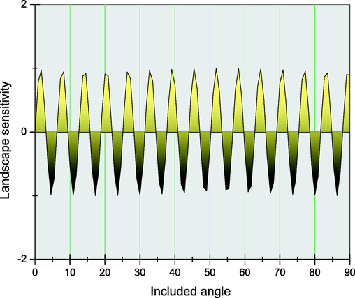
- The relation between Angle α and visual sensitivity.
In general, when the viewer is looking up or up, the Angle α is the relative slope of the terrain. According to the requirements of different precision, the relative slope of the terrain can be calculated and analyzed in GIS software, and the results can be visualized by the visual sensitivity classification (Shi et al., 2023). According to the elevation map (DEM) of the study area, the surface analysis tool of GIS is used to draw the slope map of a scenic spot. The GIS spatial analysis function is used to reclassify the slope, and the root slope classification table is used to draw the visual sensitivity grading chart of the relative slope landscape, as shown in Fig. 5.
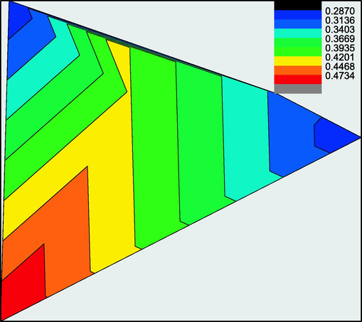
- Grading map of visual sensitivity of landscape with relative slope.
4.2 Relative distance visual sensitivity
The degree of attention of a landscape is also related to the relative distance between the landscape and the viewer. The closer the viewer is to the landscape, the higher the clarity of the landscape and the higher the visual sensitivity (Swetnam et al., 2017). It is assumed that the maximum distance between some landscape elements and the form is D, and the actual distance of the viewer to the landscape is d. When d ≤ D, the viewer can clearly observe the elements and form of the landscape, then the Z value of landscape visual sensitivity in this area is set as 1. When d > D, the viewers cannot clearly distinguish the details of the landscape, then the Z value of the landscape visual sensitivity in this area will be between 0 and 1, and the Z value can be expressed as Formula 2:
In the process of calculation, the value of D can be determined according to the accuracy of evaluation. When the accuracy is lower, the value of D will be larger, and vice versa. Assuming within the range of D value, the viewer is required to be able to clearly distinguish the elements and forms of the landscape, then D value is small, and the range can be several meters to dozens of meters. On the contrary, the D value is relatively large, ranging from a few hundred meters to about 1,000 m. When the value of D is determined, the site is divided into several distance zones according to requirements, and the corresponding hierarchical distribution map of landscape visual sensitivity Z is drawn. In the application of this method, the position of the viewer should be determined first. The main viewing routes in the scenic area are used as the baselines for dividing the distance zones (Gordon, 2018). According to the actual investigation, when located on the main tour route, the features and details of the landscape can be clearly observed within 100 m of the line of sight, while it is difficult to appreciate the landscape clearly if the observation position is larger than 500 m. The grading method of relative distance visual sensitivity in this paper is shown in Fig. 6.
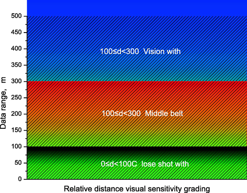
- Relative distance visual sensitivity grading chart.
4.3 Visual acuity of viewing odds
Viewing probability refers to the number of times the landscape appears in the visual field of the viewer. The higher the viewing probability is, the more times the landscape is observed by the viewer and the higher the visual sensitivity is. Assuming that the total viewing time of the viewer in a certain area is T, and the total appearance time of a certain landscape within the line of sight is set as t, the landscape visual sensitivity of the occurrence probability of the landscape can be expressed as Formula 3:
If a certain landscape appears in the horizon during all viewing activities, then the visual sensitivity of this landscape W = 1, and the visual sensitivity of other landscapes is between 0 and 1. Theoretically, the values of t and T can be obtained through statistics, but it is difficult to accurately determine the values of t and T in practice. It is assumed that the viewer travels at a constant speed, and the viewer watches along a certain route. W can be expressed as Formula 4:
Landscape sensitivity is a measure of the degree to which the landscape is noticed, it is a comprehensive reflection of the landscape's eye-catching degree, etc., and is closely related to the spatial location and physical properties of the landscape itself. The greater the slope of the landscape surface relative to the viewer's line of sight (0 ≤ α ≤ 90°), the greater the possibility that the landscape will be seen and noticed, or that it will be less easy to obscure the landscape (e.g. through greening or other masking paths).In this paper, the observation route with a total length of 2409.95 m is divided into 26 sections according to a section of 100 m, with a total of 26 segmentation points. The visibility of each segmentation point is obtained through the visibility tool of GIS, and the visual probability of a certain landscape is the route length of the landscape that can be seen/the total length of the tour route (Shen et al., 2022). According to the above formula, the visual sensitivity Z of any landscape in the scenic spot can be determined, and then Z can be divided into several sensitivity levels according to the research needs, and the corresponding hierarchical distribution map of landscape visual sensitivity Z can be drawn. After calculation, the number of visible road segments at the landscape points with the highest visual probability in the study area is 25, and the number of visible road segments at the least is 0. In this paper, the visual probability sensitivity is defined as follows: when the number of visible roads is 0 ≤ N ≤ 8, it is a highly visible region, when the number of visible roads is 8 < N ≤ 16, it is an in-visible region, and when the number of visible roads is 16 < N ≤ 25, it is a low-visibility region.
4.4 Visual acuity
The eye-catching degree of the landscape is mainly determined by the public's attention to the landscape and the contrast between the landscape and the surrounding environment. The degree of public attention to the landscape is related to the visibility of the landscape itself. The higher the visibility, the higher the sensitivity of the landscape. The comparison between the landscape and the surrounding environment includes the contrast of lines, colors, textures, and movements, and the higher the contrast, the higher the visual sensitivity (Huang et al., 2019). The selection of landscape should follow the following rules, first of all, must have ornamental, scientific and cultural value; secondly, natural scenery, humanistic scenery to be more concentrated; thirdly, it is available for people to visit, rest and conduct scientific and cultural activities. For example, the skyline formed by the mountains or trees with obvious lines, the buildings with contrasting colors with the surrounding environment, the dynamic cable cars, and the peculiar natural landforms, etc., are all the landscapes with high eye-catching degree. Natural landscape in different viewing positions, due to the distance, angle, elevation of the change caused by the perspective relationship, depth level, the difference in the field of view, the resulting aesthetic differences. The eye-catching degree of the landscape can be determined according to the field investigation and marked out in GIS. According to the following based on SD method the visual landscape evaluation of scenic spot, select “colorful”, “novelty” “attractive” these three factors on the calculation of various spots to score, and from high to low rank, choose the colors should be bright spots: There are 10 distinctive scenic spots in the first half and 17 more attractive ones in the second half; 8 of them are highly visible as eye-catching spots with unique terrain. In GIS, these 5 highly sensitive scenic spots are taken as the center of the circle and a circular buffer zone with a radius of 30 m is taken as the area with relatively striking and high visual sensitivity (Kang, 2021). The striking scenic spots are mainly concentrated in the first half of the main tour route, while the landscape in the second half is relatively plain in terms of visual attraction.
4.5 The comprehensive score of visual sensitivity in the visual area of each scenic spot
Through the analysis of the evaluation index of visual sensitivity, the sensitivity grades of the visual areas of each scenic spot are shown in Fig. 7. Low-sensitive areas are indicated in purple, sensitive areas are indicated in orange, and highly sensitive areas are indicated in yellow.
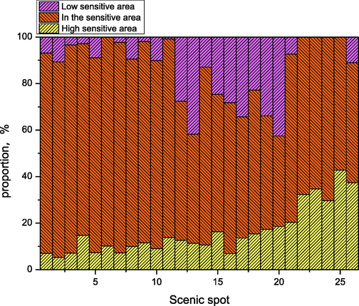
- Sensitivity fractional map of visual area.
Through calculation, the comprehensive score of visual sensitivity was obtained, and most of the visible areas of scenic spots were around medium sensitivity, as shown in Fig. 8. No. 17 scenic spot has no accessibility, so the sensitivity score cannot be obtained by means of visual area. However, as a symbol of characteristic landforms, it has a high popularity and a wide field of vision, so it can be viewed from the viewing platform on the top of the mountain without blocking. The most visually sensitive spot was ranked 25th, while the most visually sensitive spot was ranked 13th. This paper assesses the visual sensitivity of the landscape based on GIS, which provides a new way of thinking and technical means for landscape planning and design, and has important research significance; the architectural landscape based on geo-environmental protection constructed in the paper verifies that the architectural landscape and the geo-environmental landscape of geo-environmental protection can be organically combined to make the landscape have stronger visual attractiveness.
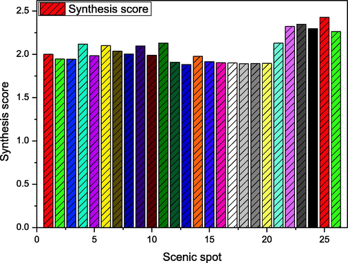
- Statistical chart of comprehensive score of visual sensitivity.
This study is a theoretical work on landscape planning for the protection of geological environment, therefore, the planning plans for this study must be site-specific. The same planning cannot be applied to different types of geological landscapes, which is the limitation of this study.
5 Conclusions
This paper expounds the geological landscape system and resource system, and introduces the architectural landscape features of environmental landscape protection. Combined with the geological environment planning architectural landscape, the concept of architectural planning and landscape design is integrated, the architectural landscape based on geological environment protection is constructed, and the spatial organization and layout of buildings in the environmental landscape is planned. Systematic analysis of landscape resources system elements composition, mutual relations, evolution law and driving mechanism. Try to make use of the original natural conditions, to avoid local topography, vegetation, hydrology of a large range of changes. There are interconnection, mutual influence and interdependence between the whole system and the elements, among the elements and between the whole system and external environment. The geological landscape resource system and the external environment can constitute a larger system. Through calculation, the comprehensive score of visual sensitivity of the visual areas of each scenic spot was obtained, and most of the visual areas of scenic spots were in the area of medium sensitivity. No. 17 scenic spot has no accessibility, so the sensitivity score cannot be obtained by means of visual area. With high visibility and wide field of vision, the viewing platform on the top of the mountain can be viewed without any shelter, so the visual sensitivity should be higher than other scenic spots. This study has achieved certain achievements, and has certain limitations due to the small number of research objects. In future research, more architectural landscapes in different areas can be selected for study, and the architectural landscape can be analyzed in both spatial and temporal comparisons, to better guide the ecological planning of the architectural landscape and propose a reasonable ecological management plan for the architectural landscape to promote the relevant research on landscape conservation.
Acknowledgements
The “Thirteenth Five-Year” Planning Project of Shaanxi Education Science in 2018 “Research on Traditional Architectural Carvings in Guanzhong Based on Contemporary Development Environment” Project Code: sgh18h160 Research Results.
Declaration of Competing Interest
The authors declare that they have no known competing financial interests or personal relationships that could have appeared to influence the work reported in this paper.
References
- Evaluation of the sustainable tourism potential of a protected area for landscape planning: a case study of the ancient city of Pompeipolis in Kastamonu. Int. J. Sust. Dev. World. 2015;22(6):490-495.
- [Google Scholar]
- A brief history of landscape research. In: The Routledge Companion to Landscape Studies. Routledge; 2018. p. :1-15.
- [Google Scholar]
- Identification and evaluation of landscape as a precondition for planning revitalization and development of mediterranean rural settlements—case study: Mrkovi Village, Bay of Kotor, Montenegro. Sustainability. 2019;11(7):2039.
- [Google Scholar]
- Chronicles and geoheritage of the ancient Roman city of Pompeiopolis: a landscape plan. Arab. J. Geosci.. 2018;11(24):1-12.
- [Google Scholar]
- Evaluation vs landscape planning in the Italian framework. TeMA-J. Land Use Mobility Environ. 2021:25-38.
- [Google Scholar]
- Landscape and visual. In: Methods of Environmental and Social Impact Assessment. Routledge; 2017. p. :399-431.
- [Google Scholar]
- Investigating the time evolution of a rural landscape: How historical maps may provide environmental information when processed using a GIS. Ecol. Eng.. 2019;139:105580
- [Google Scholar]
- Geomorphology applied to landscape analysis for planning and management of natural spaces. Case study: Las Batuecas-S. de Francia and Quilamas natural parks, (Salamanca, Spain) Sci. Total Environ.. 2017;584:175-188.
- [Google Scholar]
- The Landscape Inventory of Galicia (NW Spain): GIS-web and public participation for landscape planning. Landsc. Res.. 2019;44(2):212-240.
- [Google Scholar]
- Evaluation for landscape aesthetic value of the Natural World Heritage Site. Environ. Monit. Assess.. 2019;191(8):1-20.
- [Google Scholar]
- Managing multiple ecosystem services for landscape conservation: a green infrastructure in Lombardy region. Procedia Eng.. 2016;161:2297-2303.
- [Google Scholar]
- Geological landscape and stone heritage of the Genoa Walls Urban Park and surrounding area (Italy) J. Maps. 2018;14(2):528-541.
- [Google Scholar]
- Mapping of bioclimatic comfort for potential planning using GIS in Aydin. Environ. Dev. Sustain.. 2018;20(1):361-375.
- [Google Scholar]
- Degradation of bisphenol A in aqueous environment using peroxymonosulfate activated with carbonate: Performance, possible pathway, and mechanism. J. Environ. Chem. Eng.. 2021;9(4):105419
- [Google Scholar]
- Efficient subtle motion detection from high-speed video for sound recovery and vibration analysis using singular value decomposition-based approach. Opt. Eng.. 2017;56(9):094105.
- [Google Scholar]
- DANTD: A deep abnormal network traffic detection model for security of industrial internet of things using high-order features. IEEE Internet Things J. Early Access 2023
- [Google Scholar]
- Quantifying visual landscape quality in rural Wales: A GIS-enabled method for extensive monitoring of a valued cultural ecosystem service. Ecosyst. Serv.. 2017;26:451-464.
- [Google Scholar]
- Geoheritage, geotourism and the cultural landscape: Enhancing the visitor experience and promoting geoconservation. Geosciences. 2018;8(4):136.
- [Google Scholar]
- Biomimetic vision for zoom object detection based on improved vertical grid number YOLO algorithm. Front. Bioeng. Biotechnol.. 2022;10(5):847.
- [Google Scholar]
- Integrating GeoDesign with landscape sustainability science. Sustainability. 2019;11(3):833.
- [Google Scholar]
- Street architecture landscape design based on Wireless Internet of Things and GIS system. Microprocess. Microsyst.. 2021;80:103362
- [Google Scholar]


