

Translate this page into:
Research on urban spatial structure based on the dual constraints of geographic environment and POI big data
-
Received: ,
Accepted: ,
This article was originally published by Elsevier and was migrated to Scientific Scholar after the change of Publisher.
Peer review under responsibility of King Saud University.
Abstract
A large number of cities in China have proposed the spatial development strategy of polycentric in their planning, but whether the evolution of polycentric structure meets the planning expectation and whether the polycentric structure and function can be identified through effective ways has become a hot topic of academic research at present. Compared with the traditional survey and identification methods of population, land use and industry, the emergence of urban big data provides an opportunity for polycentric identification, especially the analysis based on POI (Point of Interest) big data is more accurate and efficient than the traditional methods. Chongqing, as a typical representative of mountainous cities, has chosen the development model of polycentric clusters at an early stage and strengthened it in the planning, forming a real polycentric city with both form and function, which makes it typical and representative among polycentric cities in China. Based on the POI data of Chongqing's main urban area, the paper identifies the polycentric structure of the city as a whole and different functions and its influence range based on the spatial distribution characteristics and aggregation degree of the overall and different types of POI data. The results show that Chongqing, as a mountainous city, exhibits an obvious “polycentric and clustered” structure under natural constraints and planning guidance. The study of Chongqing can reveal the differences between the polycentric characteristics of mountain cities and plain cities, summarize the effectiveness and shortcomings of polycentric development, and provide useful reference for urban planning. This paper collects all kinds of geospatial data, network big data and all kinds of historical statistical yearbook data in the main urban area of Chongqing. The experimental results show that by using the double constraints of POI big data and geographical environment, Chongqing is in urban polycentric structure, different functional types of urban centers, and employment function space and leisure and recreation function space have many advantages.
Keywords
Urban spatial structure
Polycentric
POI
Geography
Space syntax

1 Introduction
As the application of big data becomes more widespread and the technologies of big data collection and mining and data visualization become increasingly mature, planners and scholars of urban geography have realized the importance of big data for the study of urban spatio-temporal behaviour. It provides new analytical methods and technical innovations for the application of cities on physical and social spaces of cities, and provides new opportunities for the study of urban spatial structures. It is a new method for the study of urban spatial structure in the era of big data through the distribution of urban elements distribution characteristics and urban resident’s spatio-temporal behaviours, which allows spatio-temporal simulation of urban spatial structure (Jiaqi, 2021). At present, urban spatial research includes research on urban hierarchical structure, urban land use and functional layout, urban regional connection, and urban behavioural space (He et al., 2018). And POI, as the aggregation and analysis of multiple dimensions of a geographic location and it can bring richer information for the analysis of urban spatial structure (Deng et al., 2019).
POI usually refers to the point elements of geographic entities on electronic maps that are closely related to urban socio-economic and people's life, covering various socio-economic sectors in regional elements (Yan et al., 2021). In some cases, POI also refers to all geographic points that receive more attention than ordinary point elements (Hu et al., 2019). In the early stage, POI data were mainly used for network information query, travel map navigation and other functions, and gradually turned to POI geographic information mining and application research as the data collection and processing technology became more mature (Xue et al., 2020). POI provides new idea for innovative empirical research and application of human-earth relationship, which integrates the application of POI point, line and surface vectors to identify and evaluate the spatial pattern of human-earth system elements, characterize and predict the spatial distribution of human activities, and explore and analyze the coupling relationship of human-earth system. Theoretically and empirically, it has enriched the human-land research system.
Recent studies have started to use location based services (LBS) social media data, urban heat data and big data, and combine them with conventional census data and night time light data to quantitatively identify polycentric urban structures (Hu et al., 2019). Considering the limitations of traditional data and conventional census, POI big data provides an accurate and effective alternative way to spatially identify and quantitatively study urban centers by different functional types while exploring the overall spatial structure of cities, and finely identify the highly spatially differentiated features within cities (Hu et al., 2020). POI data are point data of real geographic entities with spatial and attribute information, high precision, wide coverage, fast update and large data volume, which are widely used in urban research (Fu et al., 2021). At present, most of the urban studies based on POI data by domestic and foreign researchers focus on many aspects, including, urban structure research, urban boundary extraction, urban population spatial and temporal change groups. Compared with traditional survey methods, the identification study of urban centers based on POI big data can effectively save analysis time and improve research accuracy (Zhang et al., 2021). However, there are not many studies using POI data for multi-center research.
The literature linked the mountain environment and urban planning to establish the interdisciplinary discipline of “mountain urbanism”, which was very innovative, and large number of studies on mountain urban space have been enriched, such as the use of dialectical method to explore mountain urban planning in the literature (Hu et al., 2018; Cai et al., 2017). The literature explored the model of land expansion for mountain cities in the context of western development and accelerated urbanization (Zhu, 2021). In literature (Zhang et al., 2021), it is considered to study the interrelationship between spatial structure and performance, explaining the factors affecting this relationship in mountain cities and optimizing it in three aspects, such as crossing the topographic threshold, building a multi-center system and improving the spatial structure hierarchy. In addition, literature (Veneri, 2018) used ENVI, ArcGIS and SPSS to statistically analyze the land use in Chongqing to reveal the patterns and dominant characteristics of the evolution of urban spatial structure; in addition, previously studied the interaction between transportation system and spatial structure in south-western mountainous cities (Xu et al., 2021). Many regions in China are surrounded by mountains and water, and the way of using mountain elements from ancient times to the present is rich and reflects certain philosophical connotations (Wu et al., 2022).
The urban spatial structure itself is a multidisciplinary research object, and the analytical perspectives of different disciplines are significantly different and inevitably skewed in terms of emphasis (Chen et al., 2018). Therefore, this paper, deals with popular POI big data processing, and analyzes into the different characteristics and different demand distribution of the city reflected by the massive data, that is, the center of the city (Veneri, 2018). On the other hand, this paper combines geographic information, which is the basic element of urban spatial structure, with the characteristics reflected in the POI big data and the rich geographic information of Chongqing city itself for screening, so as to identify more accurate urban centers and urban spatial structure.
2 POI big data information collection system based on hierarchical structure
2.1 POI big data information collection system research
This paper explores the main city of Chongqing as the research area of urban polycentric spatial structure for the following reasons. First, as a typical mountainous city, the main city of Chongqing has the spatial pattern of “two rivers and four veins”, which has the natural advantage of building a “multi-center” and “multi-cluster” city. With natural barriers such as mountains and water systems, urban construction space can be laid out in a multi-center cluster pattern, and the urban planning concept has been adopting the “multi-center cluster” development idea (Jang and Song, 2020). On the other hand, Chongqing is in the midst of rapid development, with the resident population in the main urban area of Chongqing growing from 5.278 million in 1997 to 8.518 million at the end of 2016, and the pressure of urban spatial outreach has increased, with the built-up area expanding outward in the form of clusters (Chen et al., 2019). Therefore, Chongqing, as a typical polycentric city, has been chosen as a strong representative case for the study. The POI data collection management and analysis system was described in Fig. 1. The system mainly contains information collection, standardized process of data, data storage, geocoding, data retrieval and data visualization. In particular, the geocoding and data retrieval module are useful in-depth analysis and research on the region by using the characteristics of POI big data and geographical environment, so as to obtain the optimal spatial distribution.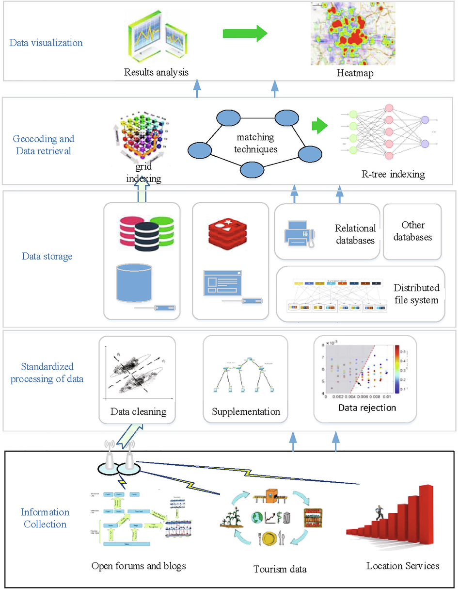
POI data collection management and analysis system.
As a city of mountains and water with a long history of civilization, Chongqing has a rich urban skyline with intertwined mountain and water contours and multi-level architectural contours, which together construct the characteristics of Chongqing as a city of mountains and water. Chongqing is the largest mountainous city in the west of China, with the topography sloping to the north and south in the form of “one mountain, one trough and two ridges”, with undulating topography and a strong sense of three-dimensionality. The central and eastern part of the city is dominated by low and gentle hills, and the main city is located in the hilly area between Zhongliang Mountain and Zhenwu Mountain, divided into three parts by Yangtze River and Jialing River: the peninsula area, the northern and the southern area.
2.2 Urban polycentric identification based on the dual constraints of geographic environment and POI big data
Traditional urban land use data mainly comes from local governments and land and other related departments, which is relatively difficult to obtain and has a long update cycle, while open source POI data can be collected for free in online mode and can provide precise location information of some entities in the urban economy. It can be used for spatial pattern research of urban facilities, urban environment evaluation, division and assessment research of urban functional space.
On the other hand, the complex geographic environment usually presents a unique geographic landscape, and thus can be characterized by the following three methods. The first is the spatial pattern of urban facilities, which is an objective spatial description of the elements of the human-land system, using spatial statistical analysis methods such as density estimation to characterize the distribution of urban single elements such as aggregation and dispersion. The second is the evaluation of urban environment, which uses cross-type POI data to comprehensively assess the convenience of urban facilities to provide residents with living services, and on the basis of the spatial pattern of urban entities characterized by POI, it reflects the interaction between people and places through the information of human activities carried by urban entities. The third is the division of urban functional space by measuring the spatial density of POI of urban entities and dividing urban space by the high value area of certain type or types of POI density, which is also the main research object to reflect the spatial pattern of human-land system elements based on POI data.
In the process of urban development, geographic entities within cities are characterized by rapid conversion in both volume and quality, which objectively promotes the development of POI data collection and update technology (Li et al., 2019). This provides the data basis for POI big data analysis. With the popularity of social networks, microblogs, public reviews and social media provide rich information, and the social attributes of the crowd in POI data can be collected through network information acquisition technology; for large map websites such as Sky Map, Baidu and Gaode, the multifaceted information of architecture and geography as well as the travel trajectory of the crowd in POI can be obtained by using the search interface or web page parsing technology. In order to facilitate data storage and retrieval, data information must be strictly managed, which mainly includes standardized processing, geocoding, model storage and data retrieval to provide reliable data support for subsequent analysis. The standardized processing of POI data is an important basis for subsequent processing such as geocoding, which mainly includes the supplementation of missing information, cleaning of erroneous data, elimination of duplicate records and other operations, and is generally programmed according to statistical principles and certain rules (Liu et al., 2019). The storage structure includes relational database, non-relational database and distributed file system based on supporting distributed expansion. CBASE distributed file system developed for POI has the ability to store and access spatial data quickly under high concurrency, and has become the mainstream storage technology because of its advantages of convenient network transmission, high reliability and expandability. Data retrieval methods mainly include grid indexing, quadtree indexing, R-tree indexing and other methods (Liu et al., 2019). Map visualization of POI data requires different dimensional analysis and judgment of the collected POI data such as POI density analysis, multi-factor cluster analysis, etc., selecting appropriate measures and evaluation criteria for POI data, extracting effective information from the POI database, and reflecting it through heat maps and other The graphs reflect it, so as to accurately reveal the spatial structure and development trend of the city.
The process of collecting POI information is necessary to gather information such as cell phone signaling, social media, check-in data, cab pick-up and drop-off points, and navigation trajectory of the crowd (Fig. 2). On the other hand, it is necessary to collect the geographical location information, name, building volume, building attributes and other information of the building. The data are calculated into the parameters of POI mixing degree by multi-dimensional index measurement method, and cluster analysis methods are used to analyze and filter all the collected data with different measurements, thus forming heat maps with different attributes, and different central areas of the city can be obtained according to the heat maps. And since Chongqing is a city with topography that is complex, it is necessary to combine different geographic information such as mountains, hills, valleys and basins for comprehensive analysis in the analysis process, and let the geographic information decompose the global clustering into multiple local areas for local clustering in the cluster analysis, so as to analyze the urban center and urban spatial structure that match with the actual one.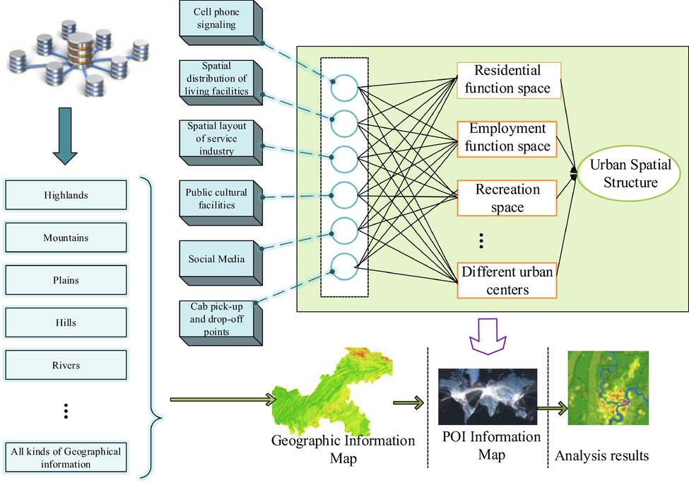
The dual constraints method of geographic environment and POI big data.
3 Analysis methods of geographic environment and POI big data
3.1 Analysis methods of geographic environment constraints
The present work was carried out on the basis of a thorough sorting, summarizing and induction of relevant literature at home and abroad, drawing on and proposing a more effective and systematic research method for analysis. By analyzing and summarizing the research on polycentric city development at home and abroad, the spatial pattern and formation mechanism of the current polycentric of large cities are outlined (Lu et al., 2020). Combining traditional methods with emerging methods data, we propose a more scientific and comprehensive method of polycentric measurement, and construct a scientific research framework and development model of urban polycentric spatial structure theory.
Qualitative analysis method. It is also important to analyze the paths and mechanisms of urban polycentric evolution (Zheng et al., 2019; Wang et al., 2021). This study analyzes the characteristics of the polycentric structure of Chongqing based on spatial analysis, combines the research of related researchers, analyzes and summarizes the mechanisms of the formation of the polycentric urban structure from land use planning, urban planning, socio-economics, and government-related policies, etc. Meanwhile, the future development direction of the polycentric system in Chongqing is proposed to provide some suggestions for urban planning.
This study adopts multidimensional indicator measurement method and multidisciplinary intersection method to identify urban polycentric urban structure using geospatial big data in order to enhance the accuracy of polycentric analysis. The data in this paper mainly include three types: the heat map of desirable travel, map POI, and building density data. The three types of index data reflect three different urban element dimensions: population, facilities, and buildings, and they are all closely related to the formation of urban form.
Firstly, based on the acquired data information, a spatial analysis database of indicators is established under the GIS platform. In order to unify the analysis scale, the data of each indicator is rasterized 100 × 100 m in this paper, so as to accurately reflect the urban spatial structure. ArcGIS software is used to process each indicator, and the calculation of all three types of data is done with each raster as a unit. The heat map uses geospatial statistics to count the number of points within the raster. The POI mix reflects the functional mix of a city's facilities, with a high mix reflecting a high functional mix.
Exploring the characteristics of urban polycentric distribution based on cluster analysis method Local hotspot analysis (Getis-OrdGi) can perform spatial cluster analysis on spatial units to explore the cold hotspot clustering areas of urban elements in spatial distribution. In order to more precisely analyze the distribution of each index on different spatial degree of clustering, we use the local G-statistic based on local spatial autocorrelation under the spatial statistics function module of ArcGIS10.2 platform to perform spatial clustering analysis on the density distribution of various indicators, and use the natural break method (Jenks) to classify and grade the calculated density spatial clustering Z (GiZScore) worth score, so as to derive the density of each indicator in the main urban area of Chongqing Spatial clustering Z score distribution for each indicator in the main urban area of Chongqing (Lang et al., 2020). Among them, the Getis-OrdGi calculation formula.
3.2 Comprehensive identification of urban polycentric structure
A city is a complex body with a variety of constituent elements. The analysis of multidimensional indicators representing different urban elements can reflect the spatial structure characteristics and evolution law of a city more comprehensively than single elements, and we analyze the three types of indicators comprehensively, and the results can better reflect the comprehensive nature of regional centers.
In order to make all the values under a unified research scale, the Z-values derived from the clustering analysis of the three indicators are standardized so that each indicator takes values in the range of 0–100, and the spatial superposition analysis of multiple elements is carried out by using the Raster Calculator, and the superimposed results are averaged, and the final results are divided into five agglomerations of low, medium, and high according to the natural fracture method to identify the main and sub-centers of the city using the degree of agglomeration.
The three main modes of daily life of urban residents are employment, residence, leisure and entertainment. The initial POI data obtained has 13 types, indicating the different functions that can be provided in a city. After we de-duplicate and correct the obtained data, we divide the POIs into three categories based on their main function types: residence, employment, and recreation, thus identifying the different function types in different centers of a city, as shown in the Table 1. Of course, transportation facilities do not belong to any of the types of residence, employment and recreation, and will be excluded. Despite our classification of POIs into types, it is undeniable that certain types of POIs have multiple functions in themselves and cannot be easily classified into a single function, for example, food and beverage establishments and entertainment establishments also have a certain proportion of employment, but their role in the city for the entertainment function is greater than that for the employment function.
-
(1)
Exploring the density characteristics of different functional centers based on the kernel density analysis method. The kernel density analysis method is more widely used in urban spatial structure. The kernel density analysis method is used to calculate the density of each element of space in its surrounding neighborhood, and simulate and visualize the density distribution continuously, and reflect the relative concentration of space element distribution by the kernel density value of each raster in the image (He et al., 2020). The method sets up different search areas and assigns weights to the points falling within the search area, and the closer to the center of the search area will be assigned a larger weight. This study explores different density zones of different functional types of POIs based on the kernel density analysis method to identify their central distribution. According to the existing research cases and the actual situation of the study area, we finally selected a search radius of 1500 m for the analysis. The calculation formula of kernel density method can be expressed as:
-
(2)
Exploring the clustering characteristics of different functional centers based on cluster analysis
| POIClass | Subclass | Chongqing | |
|---|---|---|---|
| Number of POI | rate | ||
| Residential category | Residential neighborhoods, villas, dormitories, commercial residences | 10,121 | 2.46% |
| Employment | Corporate enterprises, medical, government offices, educational institutions, financial institutions, intermediaries, scientific research institutions, factories | 169,252 | 41.20% |
| Leisure and entertainment | Accommodation services, restaurants, sports facilities, shopping centers, parks and squares, entertainment venues, scenic spots | 211,039 | 51.37% |
| Transportation facilities | – | 20,374 | 4.96% |
| Total | – | 410,786 | 100.00% |
Based on the same data processing method, the three types of POI data were rasterized 100 × 100, and then local hotspot analysis was used to judge the degree of clustering of residential, employment, and leisure POIs in each center (Xu et al., 2019; Huang et al., 2021; Hu and Han, 2019). The area with a high degree of aggregation of a certain type of POI represents that the function is a higher degree of agglomeration in that area.
4 Analysis of results
4.1 Collection and source of data
In this paper, various types of geospatial data, web big data and historical statistical yearbook data were collected from the main urban area of Chongqing. Among them, the land use data include the urban land use status map (four issues in 2001, 2006, 2011 and 2016), which comes from Chongqing Planning Bureau, and digital elevation data (DEM), which is downloaded from geospatial data cloud (He et al., 2021; Kuo et al., 2018; Yu et al., 2019). POI data is obtained from Gaode Map data. The Gaode POI data contains hotspots of various categories in the city, which can represent the spatial location and attributes of various physical objects in the city, with wide coverage and high accuracy, and can abstractly characterize the spatial structure of the city. Through web crawling, a total of 410,786 valid POI data were obtained from the main city of Chongqing, and the data types were divided into 13 types (Lan et al., 2018).
The public transportation operation data uses public transportation swipe card data as commuter flow data and is able to describe the spatial pattern of urban polycentricity in terms of functional linkages. The data is obtained from the public transportation group and the rail transit group to provide the bus operation schedule, which records the daily operation frequency of each bus vehicle. The bus or metro card swipe data is obtained from Chongqing Bus Swipe Group. Cab data was also used for analysis. Cabs, as urban semi-public transportation, are an important way for people to travel. This study uses data recorded by cab GPS, including, spatial information, mileage, etc., to characterize the connection of each central group in the main urban area of Chongqing. The data of cab trajectory are obtained from Chongqing Transportation Bureau.
4.2 Comprehensive analysis of urban polycentric structure
The POI mixing degree has significant spatial differences. From Fig. 3, it can be seen that the areas with high value of POI mixture are obviously gathered in several major centers in the inner ring of the city as well as the peripheral Airport and Lijiadian clusters. It indicates that the functions of each center in these central clusters are composite and mixed, including various functions such as finance, shopping, living and entertainment, which meet the needs of people's daily life and work. For Xiyong and Chaoyuan emerging sub-centers, as well as the rest of the clusters, the POI mix is more different from the above center clusters. In the city center clusters west of Zhongliang Mountain and south of Tongluo Mountain, the development is more backward due to the remote location, and currently there is a single function, either industrial park, or recreational area, and basically no area with medium to high value of POI mix, which further confirms the large development gap inside and outside the main city of Chongqing.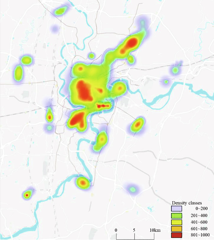
Spatial distribution pattern of POI mixing degree in Chongqing.
As shown in the Fig. 4, the polycentric structure of Chongqing was analyzed, and five clustering areas were generated from low to high. Through visual interpretation, the overall pattern identification results show that the overall pattern of Chongqing's main urban area is a typical “polycentric cluster” structure. Chongqing has obvious polycentricity in the sense of morphology, and the distribution of index scores of main and secondary centers is relatively balanced. The medium and low density areas of urban elements are distributed in the emerging urban clusters, far away from the original urban built-up areas, playing the role of satellite cities to a certain extent. The areas with very low density of urban elements are mainly distributed near slopes and mountain ridges.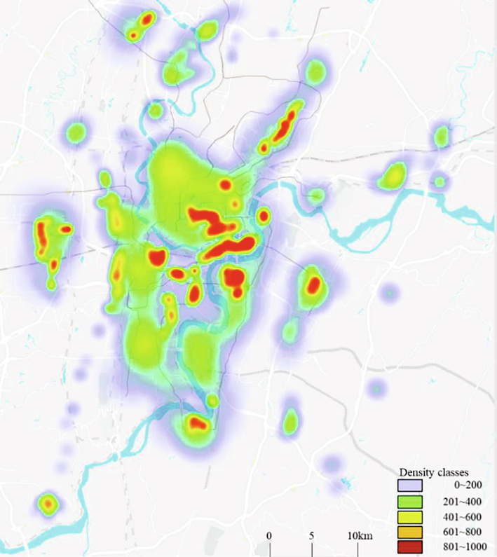
Distribution pattern of POI comprehensive indicators in Chongqing.
Overall, the development of the five major centers in the central city remains high, but the rest of the centers/clusters development is narrowing the gap with them. Furthermore, the inner ring centers are more strongly developed and closely distributed, while the peripheral centers are less developed and scattered. Overall, the centers have different degrees of development and differences in development direction, key industries, and positioning.
From the results of the above analysis of the three types of urban function spaces, the residential function space, employment function space and entertainment function space in the main urban area of Chongqing still conform to the polycentric structure in terms of overall spatial layout. Spatial distribution of different functional types is shown in the Table 2. The high-density areas and high-aggregation areas formed by residential function spaces are larger, which are better developed in the city, have formed a space for residence-employment-recreation functions, achieving a better balance of jobs and housing, and are able to meet people's daily leisure and entertainment activities. Beibei and Airport Group meet the urban residence - leisure and entertainment functional space, and is a high-quality area for people's leisure and vacation.
Space Type
Location Distribution
Residential function space
Jiefangbei, Guanyinqiao, Nanping, Shiqiaopu, Yangjiaping, Daping, Shapingba, Beibei, Xingang
Employment function space
Jiefangbei, Guanyinqiao, Nanping, Shiqiaopu, Yangjiaping, Daping, Shapingba
Leisure and entertainment function space
Jiefangbei, Guanyinqiao, Nanping, Shiqiaopu, Yangjiaping, Daping, Shapingba, Airport, Xiyong, Beibei, Lijiatuo, Dadukou
4.3 Identification and analysis of different functional types of urban centers
The residential function, as an important functional component of the city, has been an important research object in urban geography and planning. Based on the acquired POI data, the POI types that can reflect the characteristics of urban residential function are screened out, including the types of neighborhoods, villas and commercial districts, with a total of 10,121 items, accounting for 2.46% of the total. Each POI data represents a residential district, and its identification of the spatial pattern of residential functions has good accuracy.
The spatial kernel density analysis of residential functions was described in Fig. 5. There are seven high-density distribution centers, and within a radius of 1500 m, the residential neighbourhoods reach 54–95. Among them, the high-density centers with larger area are Guanyinqiao, Jiefangbei and Nanpingcenters, and the high-density centers with smaller area scale are Shapingba, Daping, Shiqiaopu and Yangjiapingcenters, which have the advantage of larger scale, and they are all distributed within the inner ring of the main city, forming the multi-center distribution pattern of residential space. Secondly, due to the agglomeration effect of the above centers, a higher density of residential function space is formed around them, while a higher density of residential space is also formed in the peripheral airports and Beibei group. From the whole spatial layout, each high-density or higher-density residential space is distributed along the light rail line and near each rail station, which indicates that rail transportation has a strong guiding effect on the distribution and expansion of urban residential space.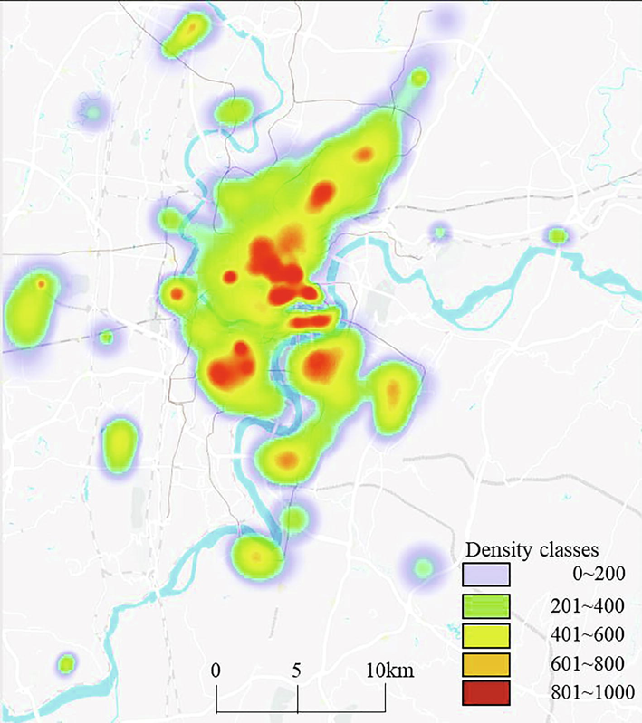
Nuclear density analysis of residential functional space in the study area.
4.4 Employment function space and leisure and recreation function space
The employment function is one of the main functions of the city, and the employment function space, as an important part of the urban space, has a non-negligible influence on the operation of the basic functions of the city. After screening, 169,252 POI data characterizing employment functions were screened, accounting for 41.20% of the total. In terms of the attributes of POI data, they mainly include corporate enterprises, medical care, government offices, educational institutions, financial institutions, intermediaries, research institutions, factories and other institutions. There are obvious spatially concentrated distribution characteristics of employment function POI data, which are mainly distributed in the core areas of the city. The Nuclear density analysis of the employment function space in the study area is shown in Fig. 6.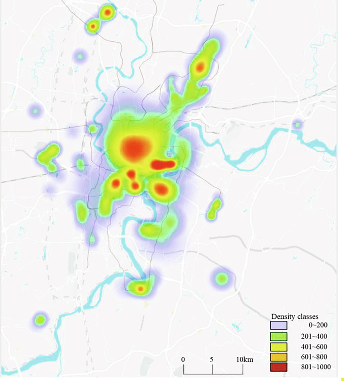
Nuclear density analysis of the employment function space in Chongqing.
The density characteristics of the spatial distribution of employment functions in the city are analyzed using the kernel density analysis method, and the results are graded by the natural breakpoint method and divided into five classes. As seen in Fig. 7, the employment function space as a whole shows the concentric circle layout characteristics of gradually decreasing from the high-density central area to the periphery. From the overall spatial structure, the employment function space forms a spatial pattern of employment polycentric within the inner ring of the city, and the pattern is more obvious, with varying sizes of influence. The peripheral employment function space is less dense, with relatively few employment opportunities, and does not form a high-density area, which may result in a state of concentration of a large number of people to the central city during work.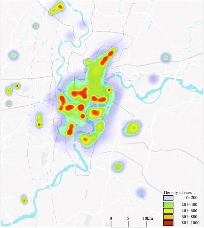
Nuclear density analysis of entertainment space in Chongqing.
Based on the POI data of leisure and recreation places, the nuclear density analysis method is used to identify the centers of spatial density distribution of leisure and recreation. From the Fig. 7, it can be seen that in the overall space, the leisure and recreation places in Chongqing show a significant polycentric distribution, with high-density areas scattered in various districts of the main urban area and more high-density areas distributed in the central core area. From the size of the distribution area of each density center, the area of the center inside the inner ring is relatively larger and has a wider influence, while outside the inner ring is relatively smaller. Leisure and recreation space density distribution is consistent with multi-center distribution, but the development intensity of each center varies, and the large high-density area is still mainly within the inner ring, and there are fewer leisure and recreation facilities in the urban fringe groups, and the multi-center form of urban leisure and recreation space needs further development.
It can be clearly seen from Table 3 that after the application of POI big data, the urban planning space has increased by 13.6%, 10.8% and 9.7% respectively from three perspectives (different functional types of urban centers, and employment function space and leisure and regeneration function space).
Elevation (m)
Proportion
Different functional types of urban centers
50.98%
Employment function space
27.40%
Leisure and recreation function space
16.21%
4.5 Analysis of the characteristics of urban polycentric structure
Studies on Chongqing show that the polycentric morphological structure of mountainous cities is a passive choice under natural constraints and ecological conservation. Chongqing's sub-centers are mainly located in river valley areas with low topography and on natural slopes with relatively high topography. The dense vegetation of Zhongliang and Tongluo Mountains and the meandering Yangtze and Jialing Rivers divide the urban areas of Chongqing. The unique geological features of Chongqing determine its distinctive urban form. The topography of Chongqing is variable, belonging to a typical parallel ridge and valley, with narrow ridges and wide valleys alternating in a north–south direction, with sharp changes in elevation between 100 m and 1000 m, and interspersed ridges, hills, cliffs, valleys, rivers, streams and ditches with wetlands. As shown in Table 3, the area of urban land in the area of 300–500 m occupied 30.86%, and 0.4% above 500 m, and the area of slope in the area of 15-25° occupied 16.21%, and 5.41% was still greater than 25°, forming the so-called “upper half of the city” in Chongqing The so-called “upper half of the city” is formed. In order to protect the rich landscape resources, Chongqing has adopted a polycentric development strategy, which is a response to the ecological wisdom of “large dispersal and small concentration” in mountainous cities. As can be seen from Table 4, urban space has been significantly improved after the application of POI big data. The improvement is mainly reflected in the effective utilization of local space in areas greater than 500 m and areas with a slope greater than 25°.
After
Before
After
Before
Elevation (m)
Proportion
Proportion
Slope
Proportion
Proportion
≤200
6.74%
9.34%
≤8°
50.98%
52.76%
200–300
62.19%
63.15%
8°-15°
27.40%
29.48%
300–500
30.86%
32.86%
15°-25°
16.21%
15.23%
≥500
0.41%
0.35%
≥25°
5.41%
2.53%
5 Conclusions
The present research work analyzes the spatial layout and polycentric spatial characteristics of different elements based on three urban elements: floor area ratio, POI mixture, and travel-friendly heat map, and identifies the development degree of different centers/groups in the city. Firstly, based on the newly acquired high-precision big data, including three kinds of data, namely building density, travel-friendly heat map and POI mixture, spatial analysis, cluster analysis and statistical analysis are used to quantify and analyze the spatial distribution characteristics and aggregation degree of each element to identify the polycentric structure of Chongqing main urban form and analyze the polycentric structure under different functions. The typical characteristics of the polycentric structure are summarized based on the above analysis. The present research work revealed the following findings. (1) The urban area of Chongqing has a typical spatial pattern of “polycentric clusters” in terms of spatial structure. In addition to the traditional “one main and four secondary” centers, the Daping and Shiqiaopucenters within the inner ring also form high-intensity areas, with the main and secondary centers distributed too closely, while the peripheral centers/groups are distributed relatively sparsely, showing the overall spatial characteristics of a tight inner and sparse outer area. (2) The degree of development of each center varies, with differences in economic development, public transportation support, and population gathering capacity. (3) The centers of different functional types in Chongqing also show obvious divergent characteristics, with a polycentric distribution of residential, employment, and entertainment functional spaces. The results show that urban planning with POI big data and underground space constraints can improve urban utilization and optimize the distribution structure of Commerce, office and entertainment. Big data is used to realize urban planning. However, with the development of the city, historical big data must not follow the trend of the times. In future planning, more art and time data should be added for better urban planning.
Declaration of Competing Interest
The authors declare that they have no known competing financial interests or personal relationships that could have appeared to influence the work reported in this paper.
References
- Using multi-source geospatial big data to identify the structure of polycentric cities. Remote Sensing Environ.. 2017;202:210-221.
- [Google Scholar]
- Quantifying the scale effect in geospatial big data using semi-variograms. PLoS ONE. 2019;14(11):e0225139.
- [Google Scholar]
- Detecting urban commercial patterns using a latent semantic information model: a case study of spatial-temporal evolution in Guangzhou, China. PloS one. 2018;13(8):e0202162.
- [Google Scholar]
- Detecting urban polycentric structure from POI data. ISPRS Int. J. Geo-Inform.. 2019;8(6):283.
- [Google Scholar]
- Identification and characterization of production–living–ecological space in a central urban area based on POI data: a case study for Wuhan, China. Sustainability. 2021;13(14):7691.
- [Google Scholar]
- The impact of urban growth patterns on urban vitality in newly built-up areas based on an association rules analysis using geographical ‘big data’. Land Use Policy. 2018;78:726-738.
- [Google Scholar]
- Evaluation of polycentric spatial structure in the urban agglomeration of the Pearl River Delta (PRD) based on multi-source big data fusion. Rem. Sensing. 2021;13(18):3639.
- [Google Scholar]
- Using wavelet transforms to fuse nighttime light data and POI big data to extract urban built-up areas. Rem. Sensing. 2020;12(23):3887.
- [Google Scholar]
- Characterization of territorial spatial agglomeration based on POI data: a case study of Ningbo city, China. Sustainability. 2019;11(18):5083.
- [Google Scholar]
- Evolving urban spatial structure and commuting patterns: a case study of Beijing, China. Transport. Res. Part D: Trans. Environ.. 2018;59:11-22.
- [Google Scholar]
- Identification of urban functional areas based on POI data: a case study of the Guangzhou economic and technological development zone. Sustainability. 2019;11(5):1385.
- [Google Scholar]
- Spatial patterns of urban green space and its actual utilization status in China based on big data analysis. Big Earth Data. 2021;5(3):391-409.
- [Google Scholar]
- Do high-density cities have better proximity?: Global comparative study on urban compactness using nighttime light data and POI BIG data. J. Korea Plan. Assoc.. 2020;55(6):5-20.
- [Google Scholar]
- Measurement and characteristics of employment centers in Shenzhen: a study using enterprise survey data in 2017. J. Landscape Res.. 2021;13(3):51-62.
- [Google Scholar]
- Efficient method for POI/ROI discovery using Flickr geotagged photos. ISPRS Int. J. Geo. Inform.. 2018;7(3):121.
- [Google Scholar]
- Temporal and spatial variation characteristics of catering facilities based on POI data: a case study within 5th Ring Road in Beijing. Procedia Comp. Sci.. 2018;131:1260-1268.
- [Google Scholar]
- Understanding livable dense urban form for social activities in transit-oriented development through human-scale measurements. Habitat Int.. 2020;104:102238.
- [Google Scholar]
- Analyzing housing prices in Shanghai with open data: amenity, accessibility and urban structure. Cities. 2019;91:165-179.
- [Google Scholar]
- Assessing polycentric urban development in mountainous cities: the case of Chongqing Metropolitan Area, China. Sustainability. 2019;11(10):2790.
- [Google Scholar]
- Mapping urban spatial structure based on POI (Point of Interest) data: a case study of the Central City of Lanzhou, China. ISPRS Int. J. Geo-Inform.. 2020;9(2):92.
- [Google Scholar]
- Urban spatial structure in OECD cities: Is urban population decentralising or clustering? Papers Reg. Sci.. 2018;97(4):1355-1374.
- [Google Scholar]
- Coupling cellular automata and a genetic algorithm to generate a vibrant urban form—a case study of Wuhan, China. Int. J. Environ. Res. Pub. Health.. 2021;18(21):11013.
- [Google Scholar]
- Cultivating historical heritage area vitality using urban morphology approach based on big data and machine learning. Comp. Environ. Urban Sys.. 2022;91:101716.
- [Google Scholar]
- Temporal and spatial heterogeneity research of urban anthropogenic heat emissions based on multi-source spatial big data fusion for Xi’an, China. Ener. Build.. 2021;240:110884.
- [Google Scholar]
- Big data-based evaluation of urban parks: a Chinese case study. Sustainability. 2019;11(7):2125.
- [Google Scholar]
- Identification method and empirical study of urban industrial spatial relationship based on POI big data: a case of Shenyang City, China. Geogra. Sustain.. 2020;1(2):152-162.
- [Google Scholar]
- Understanding urban centers in Shanghai with big data: local and non-local function perspectives. Cities. 2021;113:103156.
- [Google Scholar]
- Identification of urban functional regions based on floating car track data and POI data. Sustainability. 2019;11(23):6541.
- [Google Scholar]
- Delineation of the urban-rural boundary through data fusion: applications to improve urban and rural environments and promote intensive and healthy urban development. Int. J. Env. Res. Pub. Health.. 2021;18(13):7180.
- [Google Scholar]
- Hotspot detection and spatiotemporal evolution of catering service grade in mountainous cities from the perspective of geo-information Tupu. ISPRS Int. J. Geo-Inform.. 2021;10(5):287.
- [Google Scholar]
- Spatial accessibility to hospitals based on web mapping API: an empirical study in Kaifeng, China. Sustainability. 2019;11(4):1160.
- [Google Scholar]
- Zone division and extraction of historic area based on big data. Curr. Issues Tourism. 2021;24(14):1991-2012.
- [Google Scholar]


