

Translate this page into:
Seismic hazard assessment for the proposed site of electric power plant: Comprehensive approach
⁎Corresponding author. sqaysi@ksu.edu.sa (Saleh Qaysi)
-
Received: ,
Accepted: ,
This article was originally published by Elsevier and was migrated to Scientific Scholar after the change of Publisher.
Peer review under responsibility of King Saud University.
Abstract
Al-Sokhna area has been selected for installation one of the electric power plants along the Cairo-Suez Road. Unfortunately, this area lies within small-moderate seismicity area where some destructive earthquakes (>5), great number of earthquakes with magnitudes of less than 5 have been recorded. Through this work, earthquake events within a circle of 300 km radius around the selected site have been gathered, refined, and the affecting earthquake prone zones were recognized as; southern Gulf of Suez, Dahshour and Gulf of Aqaba source, Beni Suef and Sohag-Assuit zones however Dahshour zone is the nearest to the proposed site. The values of Peak Ground Acceleration have been assessed using deterministic and stochastic hazard approaches as 37.63 and 38.4 cm/sec2 respectively. Moreover, the pseudospectral acceleration (PSA) reaches 142, 96 and 74 cm/sec2 at damping values of 2%, 5% and 10% of the critical damping where the predominant period about 0.1 s at the selected site. These results have to be considered by policy and decision-makers to design more earthquake resistant structures at the selected site.
Keywords
Seismic hazard
Site response
Peak ground acceleration
Al-Sokhna
Egypt

1 Introduction
Earthquakes affecting all human-beings and facilities where their impact could be heavily aggravated. Accordingly, the higher safety levels for critical facilities against earthquake hazardous effects is of utmost importance for properly designed against the earthquake threat. Several studies have been applied world-wide to assess the hazard potential for the power stations (Liu et al., 2004; Salman and Li, 2017; Omidvar et al., 2017; Katona and Vilimi, 2017; Hossain et al., 2018; Jamil et al., 2019; Ziggy et al., 2019).
Recently, Egypt has a great expanding economical and industrial plan that are, in turn, dependent on the availability of reliable, low-cost and sustainable electric power. In order to meet the forecasted demand, the Ministry of Electricity & Energy (MEE) estimates that an additional 19,000 MWe of new generating capacity will be required during the next ten years. In order to achieve the highest levels of safety for these stations, the government recommended earthquake hazard assessment for these areas and take it into account for designing these stations. Then, this study aims to assess the earthquake hazard at Al-Sokhna Power Plant station through deterministic and stochastic approaches.
Al-Sokhna Power Plant is situated on the northwestern coastal zone of the Gulf of Suez (Fig. 1). The site belongs to the great developing industrial zone about 1-km south of the Al-Sokhna marine Port which is a major commercial harbor facility along the Gulf of Suez.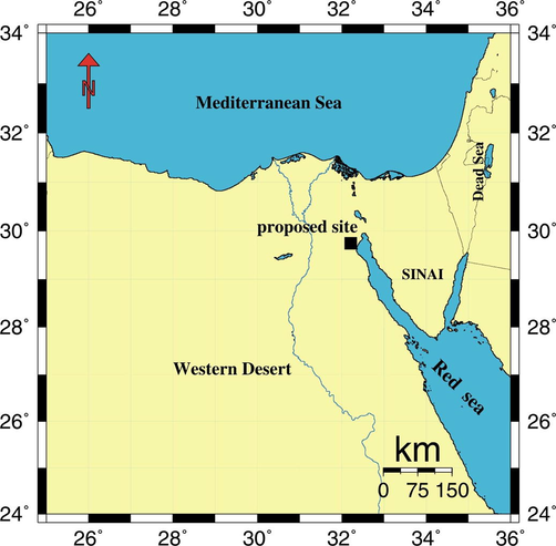
Location map of Al-Sokhna Power Plant proposed site.
2 Seismicity and seismotectonics of Al-Sokhna area
The earthquake catalogue is the focal point for earthquake hazard assessment. The available earthquake catalogue for the proposed site includes the historical observations (pre-1900) of events that occurred over a period of about 4000 years and comprehensive instrumental data for different magnitude ranges. The earthquakes data from 1900-July 2020 have been collected from Maamoun et al. (1984), Ambraseys et al. (1994) and International Seismological Center (ISC) as well as the bulletins of the Egyptian National Seismic Network (ENSN). Fig. 2 represents the distribution of the earthquake activity around the site of interest within 300 km. There are great number of earthquakes with magnitude < 3 recorded close to the site. In addition, there are various earthquakes with magnitude ranges from 3 to 4.9 occurred around the site, while the site is affected via earthquakes with magnitudes greater than 5.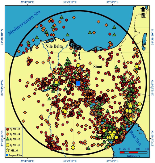
Seismicity of 300-Km circle around Al-Sokhna site.
The distribution of small-moderate to large earthquakes approve the closed relationship between earthquake activity tends and seismically active belts and trends (Abdel-Rahman et al., 2009; Abdelrahman et al., 2017). Based upon the spatial distribution of earthquakes, major tectonic trends in northern Egypt (Fig. 3, Modified after Barazangi et al., 1993; Salamon et al., 1996; Guiraud and Bosworth, 1999; Abdel Aal et al., 2000; Gamal, 2013), maximum possible or expected earthquake, maximum expected acceleration, present day stress, and correlation of earthquake epicenters with the tectonic data, the seismic sources of the area around the site of interest are defined as; Gulf of Suez and Eastern Desert source, Gulf of Aqaba, Southwest Cairo (Dahshour) seismogenic source, Beni Suef seismogenic source and Sohag-Assuit source. These areas have special seismotectonic characterizations than the rest areas of Egypt (Fig. 4).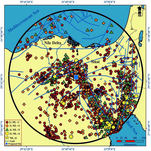
Seismotectonics of Al-Sokhna area within a circle of 300 km radius around the site, the tectonics modified after Barazangi et al., 1993; Salamon et al., 1996; Guiraud and Bosworth, 1999; Abdel Aal et al., 2000; Gamal, 2013).
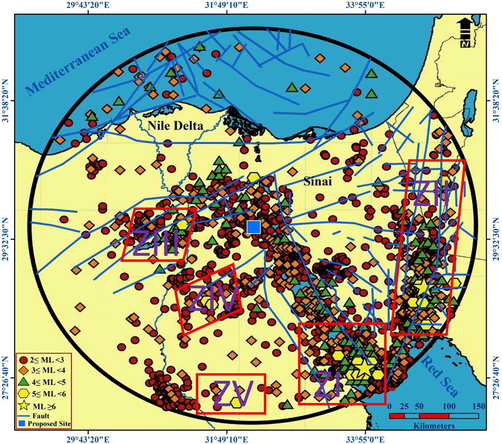
The identified seismotectonic source zones affecting the Power Plant.
3 Seismic hazard assessment
3.1 Deterministic seismic hazard approach
There are certain published relationships are applied globally based on the fault rupture length (L). Deif and Ali (2001) found such relation to be represented by the following equation:
Based on the tectonic setting prevailing at the selected site (Fig. 3) it has been noticed that the site of interest located along active faults which should be taken into consideration during the establishment of construction facilities at the site; 2) Another accepted approach based on the increasing of magnitude of the historical earthquake with 0.5 to estimate the maximum earthquake. This technique is applicable, mostly, in the regions where their fault information is inattentive.
The results of the above methods are expressed in terms of maximum expected seismic moment. The resultant maximum seismic moment could be transferred to the surface wave magnitude values using the following relationship:
3.1.1 Maximum earthquake magnitude calculation
The identified seismotectonic zones have different levels of seismic activity. Southwestern of Cairo seismic zone initiated the most hazardous earthquake in the twentieth century in October 12, 1992 with seismic moment magnitude 5.8. The maximum instrumentally observed magnitude in the Eastern Desert zone was 5.0 at Abu-Hammad region. By integration of Eqs. (1) and (2), the maximum surface wave magnitude (Ms) of this zone is 6.31. The historical technique is used for the rest of seismic sources (Table 2). Depending on this table, Dahshour source zone represents the nearest source for earthquakes to the site of interest.
3.1.2 Maximum possible acceleration at the proposed site
It is found that the seismic source of the southern southwest Cairo is expected to be the most hazardous one on the site of Power Plant. The maximum earthquake hazard based on the peak ground acceleration at the selected site is found to be 37.63 cm/sec2 resulting due to earthquake with magnitude 6.31 occurrence at distances (R) of 105.527 km at Dahshour area using the attenuation model defined by Abdel-Rahman (1999).
Accordingly, Dahshour source zone has the most hazardous effect for the selected site.
3.2 Stochastic simulation of ground motion
The synthetic ground motion model by Boore (1986), Boore (2003) [SMSIM-program] was used to determine rock level Peak Ground Acceleration (PGA) and to generate a synthetic acceleration-time history (Atkinson and Boore 1995). The value of stress drop taken as 30 bars for PGA calculations of the selected site. The whole-path attenuation is governed by the frequency dependent quality factor Q. Geometrical spreading factor is 1/r for r < 100 km and equal to 1/10 for r > 100 km, where, r is the hypocentral distance.
Distance dependent duration, which is a function of the path as well as the source, is given by
The shear wave velocity models to 30 m depth (Vs30) for equivalent rock-type sites with density used from four boreholes drilled in this study (Fig. 1). From these data, the average shear wave velocity was estimated at each site. Site amplification [A(f)] at the assumed engineering rock level was determined using quarter-wavelength method.
Where Vs30 represents the average shear wave velocity at each site, the average kappa factor for the rock site in the compensated district was obtained as 0.019. In the scaling factor, a reduction factor (H) of 0.71 was taken to represent the partitioning of the S-wave energy into two horizontal components. For radiation pattern (R ) a value of 0.55 was used (Atkinson and Boore, 1995).
Based on the soil classification at the site of interest as alluvial sediments, the amplification factor at this site will be 3.9 (Borcherdt and Gibbs, 1976). The parameters of sedimentary section through shear wave velocity profiles where, four boreholes have been drilled through the study area (Table 1). The weighted shear-wave velocities were computed according to the following formula:
Year
Mon.
Day
Hr.
Min.
Sec.
Long. (E)
Lat. (N)
Depth (km)
Magnitude Mb
1906
12
26
17
45
34.00
27.70
20
5.5
1969
3
8
10
31
54
33.80
27.50
24
5.1
1969
3
24
11
34
14
33.90
27.50
16
5.2
1969
3
24
12
50
51
33.80
27.50
13
5.3
1969
3
31
7
15
54.4
33.90
27.60
20
6.1
1972
6
28
9
49
33
33.80
27.70
15
5.6
1992
10
12
13
9
55.5
31.144
29.78
21
5.9
1993
8
3
12
54
6.3
34.777
28.60
10
5.1
1995
11
22
4
15
11.9
34.799
28.83
10
6.4
1996
2
21
4
59
51.2
34.783
28.80
10
5.1
1999
6
13
4
20
9.7
34.83
28.26
5
5.2
1999
10
5
5
44
33
35.25
28.89
33
5.6
1999
10
11
20
39
34.6
31.51
28.63
28.4
5.1
1999
10
28
15
39
15.8
35.10
30.43
25
5
2000
3
8
14
22
26.3
34.73
28.87
7
5.7
2003
6
4
9
14
49.2
31.97
27.08
10.7
5.1
2006
11
8
4
32
10
31.59
28.58
3
5.2
Seismic Source
Maximum magnitude
Distance to the site (km)
Southern Gulf of Suez
7.34
289.811
Gulf of Aqaba
7.63
270.401
Southwestern Cairo (Dahshour)
6.31
105.527
Beni Suef
5.6
144.051
Sohag-Assuit
5.6
297.097
The amplification factor is calculated based on the following equation (Midoricawa, 1987) and (TC4, 1999); A = 68. Vs−0.6. While Borcherdt et al. (1991) show a strong correlation between shear wave velocity and Average Horizontal Spectral Amplification (AHSA) as AHSA = 701/Vs where, Vs is the local shear wave velocity in m/s averaged over the soil profile.
According to Table 3, it could be concluded that; Vs(avg) ranges from 287 to 291 m/s; Amplification factor varies from 2.24 to 2.3 (Midoricawa, 1987 and TC4, 1999), and from 2.39 to 2.44 (Borcherdt et al., 1991). Both values are correlated well. This in the case of dray soil, but in the case of wet soil the porosity of soil will be increased and shear wave velocity will be decreased with about 30%, and the amplification characteristics may be reach about 3.7.
PGA has been calculated at four boreholes sites within the proposed site using synthetic ground motion models of earthquakes from Dahshour seismogenic source taken the relative amplification of the soft soil (Table 3) into consideration. The resulted PGA as 38.4 cm/sec2 (Fig. 5). The ground surface response spectra were determined at 2%, 5% and 10% of critical damping (Fig. 6). According to this figure, it is noticed that the PSA reached 70, 102 and 173 cm/sec2 at 2%, 5% and 10% of critical damping respectively at 0.1 s fundamental period.
Borehole
In case of Dry soil
In case of Wet soil
Vs(average) (m/s)
Relative amplification Midoricawa, 1987
Relative amplification Borcherdt et al. 1991
Vs(average) (m/s)
Relative amplification Midoricawa, 1987
Relative amplification Borcherdt et al. 1991
BH 1–2
291
2.3
2.4
194
2.88
3.6
BH 1–3
287
2.28
2.44
191
2.9
3.7
BH 1–4
296
2.24
2.39
197
2.85
3.6
BH 1–5
290.5
2.26
2.41
193
2.89
3.65
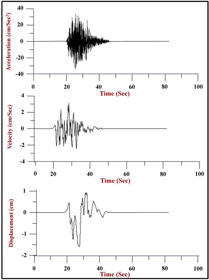
Simulated time history of the maximum PGA, PGV and PGD at Al-Sokhna Power Plant resulted from Dahshour zone.
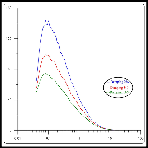
Response Spectra for Pseudo-Spectral Acceleration at Al Sokhna Power Plant.
4 Conclusions
Based on the collection of a complete earthquake data set within 300-Km around Al-Sokhna Power Plant it is indicated that the southwest Cairo (Dahshour) seismic source has the largest effect upon the site. The maximum earthquake that may occur in this source is estimated to be with 6.31 moment magnitude. Depending on the deterministic seismic hazard approach, the PGA at the site is found to be 37.63 cm/sec2 resulting from the occurrence of an earthquake with magnitude 6.31 at distances of 105.5 km. Moreover, the simulated Peak Ground Acceleration equals 38.4 cm/sec2 at the site of interest. Also, the response spectra are calculated. It is indicated that both of the maximum expected accelerations calculated by the deterministic approach and by the stochastic model are very close to each other which clarifies that both approaches are good of earthquake hazard assessment for sites of the critical value.
Acknowledgements
The authors extend their appreciation to the Deputyship for Research & Innovation, “Ministry of Education“ in Saudi Arabia for funding this research work through the project number IFKSURG-1442-123.
Declaration of Competing Interest
The authors declare that they have no known competing financial interests or personal relationships that could have appeared to influence the work reported in this paper.
References
- Abdel Aal, A. El Barkooky, A. Gerrits, M. Meyer, H. Schwander M. and Zaki, H., 2000: Tectonic Evolution of the Eastern Mediterranean Basin and Its Significance for Hydrocarbon Prospectivity in the Ultradeepwater of the Nile Delta, Shell Egypt Deepwater BV (Egypt): The Leading Edge, 2000.
- Geophysical Studies for the Selected Sites of the National Seismological Network in the Northwestern Part of Egypt. Zagazig: Zagazig Univ.; 1999. p. :188. Ph.D. Thesis
- Seismicity of Sinai Peninsula. Egypt. Arab. Jour. Geosci.. 2009;2(2):103-118.
- [CrossRef] [Google Scholar]
- Kamal Abdelrahman, Abdullah Al-Amri, Nassir Al-Arifi and Enayat Abdelmoneim, 2017. Seismic Risk Assessment at the Proposed Site of Gemsa Wind Power Station, Southwestern Coast of Gulf of Suez, Egypt. Journal Geological Society of India 89, pp.192-196.
- The Seismicity of Egypt, Arabia and the Red Sea. A historical review. Cambridge Univ. Press; 1994. p. :181.
- Ground motion relations for eastern North America. Bull. Seism. Soc. Am.. 1995;85:17-30.
- [Google Scholar]
- Tectonic Evolution of the North- ern Arabian Plate in Western Syria. In: Boschi E., ed. Recent Evolution and Seismicity of the Mediterranean Region. Kluwer: Academic Publishers; 1993. p. :117-140.
- [CrossRef] [Google Scholar]
- The effect of finite bandwidth on seismic scaling relationships, in earthquake source mechanics. In: Das S., Boatwright J., Sholtz C., eds. Geophysical monograph 37. Washington, D. C.: American Geophysical Union; 1986. p. :275-283.
- [Google Scholar]
- Simulation of ground motion using the stochastic method. Pure Appl. Geophys.. 2003;160(3):635-676.
- [Google Scholar]
- Effects of local geologic conditions in the San Fransisco Bay region on the ground motions and intensities of the 1906 earthquake. Bull. Seism. Soc. Am.. 1976;66:467-500.
- [Google Scholar]
- Methodology of predictive GIS mapping for special study zones for strong ground shaking in the San Francisco Bay Region, CA. In: Proceedings of the Fourth International Conference on Seismic Zonation. 1991. p. :545-552.
- [Google Scholar]
- Deif, A. and Ali, A. Tealeb, 2001. Deterministic seismic hazard assessment for Toshka and High Dam projects, Bulletin of National Research Institute of Astronomy and Geophysics, geophysics B, 233-263.
- Truthfulness of the existence of the Pelusium Megashear fault system, East of Cairo, Egypt. Int. J. Geosci.. 2013;4:212-227.
- [Google Scholar]
- Phanerozoic geodynamic evolution of Northeastern Africa and the Northwestern Arabian Platform. Tectonophysics. 1999;315(1–4):73-108.
- [CrossRef] [Google Scholar]
- Seismic safety evaluation during site selection for the nuclear power plants in Bangladesh. Nucl. Energy Technol.. 2018;4(4):251-256.
- [CrossRef] [Google Scholar]
- Deterministic Seismic hazard Assessment of Karora Hydro Power Plant. Int. J. Adv. Eng. Res. Dev.. 2019;6(10)
- [Google Scholar]
- Katona, T. J. and Vilimi, A., 2017. Seismic Vulnerability Assessment of Site-Vicinity Infrastructure for Supporting the Accident Management of a Nuclear Power Plant. Hindawi Science and Technology of Nuclear Installations, 2017, Article ID 2929353, 7 pages DOI:10.1155/2017/2929353.
- Gee-Yu, Liu, Chih-Wen, Liu, Yi-Jen, Wang, Wen-Yu, Jean, 2004. Seismic Risk Analysis of Electric Power Networks Using Hazard-Consistent Scenario Earthquakes. in: 13th World Conference on Earthquake Engineering, Vancouver, B.C., Canada, August 1-6, 2004, Paper No. 9.
- Maamoun, M., Megahed, A. and Allam, A., 1984. Seismicity of Egypt. HIAG Bull. Vol. IV, Ser. B.
- Prediction of isoseismal map in Kanto Plain due to hypothetical earthquake. J. Struct. Dyn.. 1987;33B:43-48.
- [Google Scholar]
- Seismic risk assessment of power substations. Environ. Energy Econ. Res.. 2017;1(1):43-60.
- [CrossRef] [Google Scholar]
- Seismicity of the Eastern Mediterranean Region: perspective from the Sinai subplate. Tectonophysics. 1996;263(1-4):293-305.
- [CrossRef] [Google Scholar]
- Salman, Abdullahi M., Li, Yue, 2017. A Probabilistic Framework for Seismic Risk Assessment of Electric Power Systems. in: X International Conference on Structural Dynamics, EURODYN 2017. Procedia Engineering 199 (2017) 1187–1192.
- Ziggy Lubkowsk, Matthew Free, Roger Musson, Manuela Villani, Crispin Oakman, Barbara Polidoro, Areti Koskosidi, Rory McCully, Ben Gilson, Martin Walsh & Tim Courtney, 2019. Seismic Hazard Assessment for The Wylfa Newydd Nuclear Power Plant. in: 2nd 2019 conference of earthquake risk and engineering towards a resilient world, 9‐10 September 2019, Greenwich, London.
Appendix A
Supplementary data
Supplementary data to this article can be found online at https://doi.org/10.1016/j.jksus.2021.101360.
Appendix A
Supplementary data
The following are the Supplementary data to this article:


