

Translate this page into:
Research on the application of neural network based external location element settlement method in object location of geographic information
⁎Corresponding author. cuijian202202@163.com (Cuijian)
-
Received: ,
Accepted: ,
This article was originally published by Elsevier and was migrated to Scientific Scholar after the change of Publisher.
Peer review under responsibility of King Saud University.
Abstract
Background
Geographical information about human settlements is necessary to facilitate humanitarian aid, recognize the location of real-world objects, support local development and improve disaster resilience in settlements. Although deep learning is employed in object location in settlements, these models have computational complexity and less detection accuracy. Hence they require further development with regards to precision in object location from geographic data.
Objective
To efficiently identify the object location in Chinese settlements from geographic information, we proposed Artificial Neural Network (ANN) optimized by Red Fox (RF) optimization (ANN-RF) model in this research.
Methods
The multi-resolution Geographic information data was collected from Tongzhou District, Beijing, China. ANN applies the measures of length, area, distance and direction to recognize object location from this data. An RF algorithm is used to optimize the weight vector of the ANN architecture to improve the efficiency of the ANN architecture. The parameters such as precision, recall, F1-score, number of correct detections, overall actual matches and the total number of detections were computed for the proposed model.
Results
The precision rate and F1-score for the proposed ANN based RF optimization are about 98.9% and 97.5% which are higher than that of conventional models.
Conclusion
The proposed ANN-RF model shows promising results in detecting object location in settlements from geographic information.
Keywords
Geographic information
Multi-resolution representation dataset
Artificial neural network
Red fox optimization

1 Introduction
A rural settlement is a countries’ environment type in which the people live and engage in production, which results from local interactions with natural, social, economic, and cultural environments (Yang et al., 2015). It provides places to live and work in the rural side (Li and Song, 2020). Geographic Information Systems (GIS) is used in various fields nowadays, which provide a fastcontrast of complex databases and support for entirely new analytical forms. Archeological GIS studies have proliferated over the past three decades (González-Tennant, 2016). Many individually developed technologies are increasingly used to support the comprehension, education, prediction, and decision-making of spatial events. These contain remote sensing and photogrammetry, digital imaging, object recognition, Artificial Intelligence, etc., which can be called spatial information technology. Most of the integrated systems are slowly becoming available as a basic technology integrated with the GIS, data manager, and other systems. The examination is done in the technologies’ potential role of many of the spatial decision support which mainly focuses on decision-making in urban contexts, especially in informal settlements (Mason et al., 1997) (Table 1).
Backward feature matching
Forward feature matching
Les detailed dataset
More detailed dataset
m:1
1:m


m:n
n:m


Settlement aggregation refers to the process of human migration, which contains two parts from different perspectives. From a social point of view, it is the process of creating a community for the people. From the point of view of physical form, it is a process by which natural or artificial elements form a physical settlement with its adjacent environment (Du and Chan, 2019). The matching algorithm is used to find the land/area is changed or not at a certain year of difference (Wang et al., 2015). The conventional methods involved in object and site detection from geographic information system (GIS) is explained below. The existing techniques using Back Propagation Neural Network (BPNN) was capable of detecting the damaged location and extent accurately (Chen et al., 2020). Here the applicability is affected by the computer characteristics variation such as noise measurement, damaged location, vehicle load, and speed. To overcome this, BPNN is used in the detection of damage to a bridge based on the statistical features of dynamic responses (Shu et al., 2013). But the recognition accuracy of the landslide detection by BPNN from spatial image must be improved. Díaz and Soares (2022) developed a selection device using the Analytical hierarchical process (AHP) for coastal wind farms combined with geographical information systems and multiple criterion analysis. A GIS-based model using interval type-2 fuzzy analytic hierarchy process (FAHP) is proposed by Ayodele et al. (2018) for the selection of suitable wind farm site in Nigeria. Zabihi et al. (2020) integrated GIS with a FAHP to evaluate the relative importance of physical, natural, environmental, and socio-economic factors for determining the suitability of ecotourism sites. Haidara et al. (2019) employed FAHP for detecting the location of soil erosion and Ali and Ahmad (2020) for recognizing the suitable landfill site. Eroğlu (2021) and Islam et al. (2020) analyzed to find suitable sites for the disposal of Metropolitan Solid Waste (MeSW) with the combination of FAHP technology and spatial information technology. Roth et al. (2017) proposed a multi-scale approach and holistic framework that provides information about the development process of land settlement projects and sustainability assessment with the comparison between EI Hierro hydro-wind power plant and sivens dam projects. FAHP require multiple factors for detecting suitable locations.
Deveci et al. (2021) utilized a new hybrid approach integrating Interval Rough Numbers (IRNs) into Best-Worst Method (BWM) to choose the best offshore wind farm site in Turkey. Taking disaster’s uncertain and subjective characters into consideration from GIS, IRN is utilized by Song et al. (2019). But IRN needs complex characteristic aggregation and arithmetic operators to identify the location in settlement. Integration of IRN would empower decision-makers in waste treatment organizations to express their judgments within an interval range to overcome indeterminacy in uncertain geographic information (Torkayesh et al., 2021). Yazdani et al. (2020) introduced a new IRN Dombi-Bonferroni (IRNDBM), as an approximate data processing operator due to the lack of accurate information, for site planning for the sanitary waste disposal. Zhang et al. (2018) suggested object-based Convolutional neural network for land use classification from high resolution images. This does not efficiently identify smaller functional objects like hospitals, supermarkets, etc in settlement.
Artificial Neural Network (ANN) has promising results in location prediction. But the number of neurons in the Artificial Neural Network architecture often leads to poor approximation and overfitting issues (Urda et al., 2021; Bejani and Ghatee, 2021). Optimization of the weight vector is also necessary to yield a better fitness value (Dani et al., 2021; Li, 2021; Mao et al., 2021) and to overcome this issue we are using a red fox (RF) optimized Artificial Neural Network to optimize the weights of the ANN architecture. The main objective of this paper is to identify the object location based on multi-resolution geographic information, gathered from Tongzhou District, Beijing, China, using ANN optimized by RF model. The weight vector of the ANN architecture was optimized by RF optimization technique to improve the efficiency of the ANN architecture in object detection from multi-resolution geographic information.
The paper is organized in the following manner. Section 2 gives some related works in the existing literature. Section 3 explains the red fox optimized ANN architecture for GIS object identification. Section 4 shows the experimental results with different performance metrics such as Recall, F1-score, and precision. Finally, section 5 deals with the conclusion.
2 Related works
2.1 Proposed methodology
The proposed methodology relies on ANN optimized RF to recognize the position of objects from the multi-resolution geographic data collected from Tongzhou, Beijing, China provided the multi-resolution geographic data. Initially, similarity between spatial features are determined. ANN learns the spatial features like length, area, distance, and direction from multi-resolution geographic data to predict the location of objects which is the output of ANN. To enhance the the effectiveness of ANN in predicting object location, the weight vector of ANN is optimised using an RF technique. The steps involved in proposed methodology is given in the below sub-section.
2.2 Dataset description
The multi-resolution geographic dataset is obtained from the Tongzhou District of Beijing situated at 36′39°–40°02′N, 116°32′–116°56′ (Song and Li, 2020). The shape of the district is comparatively huge but likely slanted from northwest to southeast. This continent has a monsoon climate along with an average temperature of 11.3 °C annually and a 620 mm rate of average precipitation. To reflect the overall scale characteristics of rural settlements in the Tongzhou District parameters CA and NP are used between them while LPI and MPS reflect the exchange in its structural pattern of rural settlements and LSI reflects asymmetry or problems in the patch shapes of rural settlements. The problem of the shape outside rural settlement patches is represented by SHAPE_MN, which reflects the effects of external activities on the rural settlements. Before the presentation, an integrated, and geometric correction of the images were performed. In keyhole rural settlements, satellite images are displayed in a variety of colors, such as graphics closely linked by many small rectangles. Settlements are displayed in a white tone, with green vegetation interspersed. With these features as attributes, it is possible to extract the rural settlements of Tongzhou.
2.3 Spatial similarity
Similarity in space and dissimilarity in space are two concepts that are usually stated in terms of each other.
2.4 Artificial neural network
The polygon features investigates the measures applied to this neural network model. The difference in length, direction, area and distance present in the inputs to match the examined pair (Kornblith et al., 2019). The below equation compute
for the distance measure
The centroid of c and d is
and
. The minimum bounding rectangle length is
. The below equation computes the
for the area of measure
From this equation, the area of c and d are
and
. The following equation calculates
for the direction measure.
The direction of c and d are
and
. Equation (5) computes the
for the direction measure.
The diagonal lengths are and .
2.5 Red fox optimization algorithm
The red fox population involves two important phases: (1) leaving well-defined territory and (2) leading nomadic life. The single territory is shared with each herd under the alpha couple hierarchy. After the growth of young ones, they move away from the herd and create another territory. Else, at one day, they occupy the territory of alpha couples. The mathematical formulation of the hunting behavior of red fox is described in the following steps.
2.5.1 Step 1: Global search
All the foxes in the herd should play a role in searching of food for the survival of each herd member. When there is a lack of food in the local region, the herd must be moved to remote locations. The collected information about the explored land is communicated with family members for survival. Based on the individual fitness, the search space is explored and the mathematical expression of the searching process is delineated in the following equations.
The terms and represents the total fox population with iteration × and the best individual in the population with iteration x.
2.5.2 Step 2: Local search
When the prey is visible to red fox, the immediate response of hunting takes place. Initially, they encircle the prey and stay down and hide before hunting (Zhang et al., 2021). Then they attack the prey suddenly or by surprise. The individual movement
distinguishes the fox action as
denotes the closer movement of red fox and
signifies the hiding behavior of red fox. In addition to this, the vision radii
of red fox are determined using the below equations.
The term signifies the scaling parameter which ranges between 0 and 0.2, is the observation angle of fox and denotes the random number lies between 0 and 1.
2.5.3 Step 3: Generation and moving away from the herd
Many hazardous situations such as fox hunting by humans and lack of prey in local territory make the red fox population depart from their own territory. In such a case, some foxes may die and some migrate to the remote destination (Połap and Woźniak, 2021). The mathematical expression of center of habitat
, Euclidean distance
and reproduction of new individual are given as follows,
The terms and represents the two best alpha couples and depict the random number.
2.6 ANN based RF algorithm for object location detection from geographic information
Fig. 1 explains the proposed ANN-RF model for object location detection from geographic information. Here, we concentrated both forward matching and backward matching. A characteristic of many full dataset contains no correlation in the low described dataset in the situation of 1:0, which is identical to 0:1 in matching of backward. A feature in the low described dataset contains no correlation in the many described dataset in the case of 1:0, which is identical to 0:1 in forward matching. The neural network met several advantages like ability of parallel processing, good fault tolerance, ability to train machine, distributed memory, store information on the entire network and etc. But, it met few shortcomings in terms of computational complexity, poor detection accuracy and etc. Hence, we combined and utilized ANN with RF algorithm to provide better object location detection from geographic information.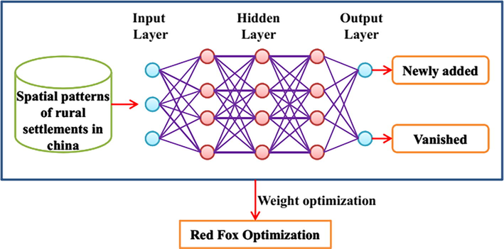
Proposed artificial neural network based red fox optimization algorithm for object location detection.
3 Result and discussion
This section explains the experimental investigation with respect to state-of-art results and performance analysis of proposed method.
3.1 Parameter settings
Table 2 represents the parameter settings of the proposed ANN based RF optimization.
Parameter
Ranges
Number of neurons in the input and output layer
100, 2
Iteration number
50
Learning rate
0.001
Activation function
Sigmoid
Random parameter
0, 1
Scaling parameter
0, 0.2
Size of the population
50
3.2 Evaluation measures
Recall ( ), F1-score and precision ( ) are the performance metrics computed for the feature matching approach. Among them the recall and precision metrics are expressed as:
From the above equation, the number of correct detections is denoted as the total number of detections are indicated as and the actual number involved is represented as . In order to determine the corresponding links, the accurate number of calculated matches are considered as the overall actual matches are denoted as and the detected variation is represented as .
The overall performance of the proposed method is compared with BPNN based, fuzzy analytic hierarchy process (FAHP), interval rough numbers (IRN) and Dombi Bonferroni (IRNDBM) methods and their results are plotted in graphical representation. Each metric for the above methods was separately determined to the efficiency of the proposed method. In Fig. 2 the precision rate of the proposed method along with IRNDBM, BPNN, IRN, FAHP based methods was determined. The data in this figure shows that the proposed method has higher precision than the other method. It has a precision rate of about 98.9%. Followed by the proposed method the next efficient method was BPNN, then FAHP, IRN, IRNDBM respectively.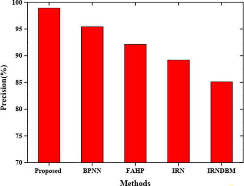
The precision rate of the proposed method along with IRNDBM, BPNN, IRN, FAHP based methods.
Fig. 3 shows the graphical representation of each method with respect to their recall rate. The recall rate of the proposed method and some existing methods were computed. The graph shows that the recall rate is lower when compared to other methods. The proposed method has a recall rate of 95.1% and the other methods have a higher rate than this. IRNDBM has possessed a maximum recall rate among all the methods. In Fig. 4 the F1-score of the proposed method along with IRNDBM, BPNN, IRN, FAHP based methods were determined. It is shown that the F1-score of the proposed method has the maximum rate among all the methods and the rate of F1-score was about 97.5%. Also, IRNDBM based method has a lower F1-score value than others and these variations are expressed in the figure. Each method’s F1-score values are individually plotted in the graph corresponding to the maximum rate order. However, the proposed method has few mismatches i.e. the proposed method has a higher F1-score, higher precision and minimum recall rate. Also, the recall rate is higher for IRNDBM.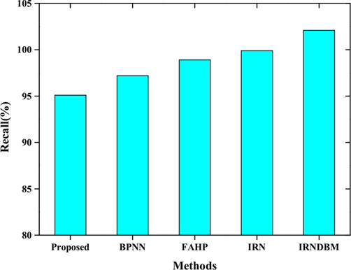
The recall rate of the proposed method along with IRNDBM, BPNN, IRN, FAHP based methods.
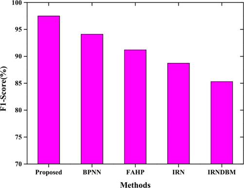
The F1-score of the proposed method along with IRNDBM, BPNN, IRN, FAHP based methods.
In Fig. 5, the total number of detection rates was computed for the proposed method along with IRNDBM, BPNN, IRN, FAHP based methods. It is shown that the proposed method has a lower detection rate than other methods. The number of detection matches obtained in the proposed method is 13874. The number of detections matches of the proposed method with IRNDBM, BPNN, IRN, FAHP is compared and estimated. Fig. 6 represents the number of actual matches with respect to the proposed method, IRNDBM, BPNN, IRN, FAHP based methods. The number of actual matches obtained in the proposed method is limited compared to other existing methods whereas the obtained is about 14272. Among them, the maximum matches were gathered by IRNDBM based method. The number of detection matches obtained by the proposed method along with various methods is represented in Fig. 7. From the graph, it is denoted that the number of correct detection matches was lower and is about 15052. However, the other methods have a higher detection rate compared to the proposed method as limited matches help to function efficiently.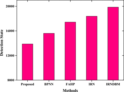
Represent the number of detection rates with respect to the proposed method, IRNDBM, BPNN, IRN, FAHP based methods.
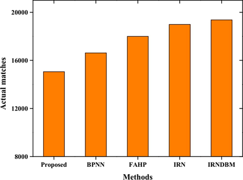
Represent the number of actual matches with respect to the proposed method, IRNDBM, BPNN, IRN, FAHP based methods.
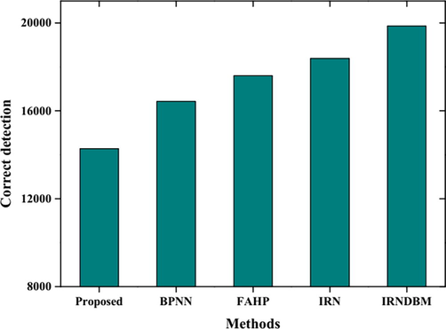
Represent the number of correct detections with respect to the proposed method, IRNDBM, BPNN, IRN, FAHP based methods.
4 Conclusion
The main aim of this paper is to propose an optimized deep learning method for accurate identification of object location based on geographic information. The optimized deep learning method utilized in this paper is RF optimized ANN architecture to accurately detect object location in Tongzhou, China from multi-resolution representation dataset. We compared the performance of the proposed ANN-RF model with existing models in object detection based on geographic images. ANN-RF model achieved precision of 98.9% and F1-score of 97.5% in object localization based on multi-resolution geographic data. The comparative analysis showed that ANN-RF showed higher precision and F1-score than existing models like IRNDBM, BPNN, IRN, and FAHP techniques. Higher precision and F1-score observed for the proposed method was due to optimization of vector weight of the ANN architecture using the RF algorithm. As a result, the proposed methodology can be adopted for object localization in settlements to facilitate identification of natural calamities and infrastructural damages. The limitations of this research are the lack of computational time requirement analysis for the proposed model in object localization in settlement and the proposed model is evaluated on geographic data collected from single district of China. Hence, in the future, time required for detection of object location from geographic information by ANN-RF model must be determined to prove its computational efficiency. Future work may involve investigating transferability of this method for the object detection in multiple geographical regions.
Acknowledgement
The authors are thankful to the higher authorities for the facilities provided.
Statements and declarations
The author declares that no conflict of interest is associated with this study.
Authors’ contribution
This study was done by the authors named in this article, and the authors accept all liabilities resulting from claims which relate to this article and its contents.
Availability of data and materials
The data used to support the findings of this study are available from the corresponding author upon request.
Funding
No funding received for this study.
Declaration of Competing Interest
The authors declare that they have no known competing financial interests or personal relationships that could have appeared to influence the work reported in this paper.
References
- Suitability analysis for municipal landfill site selection using fuzzy analytic hierarchy process and geospatial technique. Environ. Earth Sci.. 2020;79(10):1-27.
- [Google Scholar]
- A multi-criteria GIS based model for wind farm site selection using interval type-2 fuzzy analytic hierarchy process: the case study of Nigeria. Appl. Energy. 2018;228:1853-1869.
- [Google Scholar]
- A systematic review on overfitting control in shallow and deep neural networks. Artif. Intell. Rev.. 2021;1–48
- [CrossRef] [Google Scholar]
- Accurate landslide detection leveraging UAV-based aerial remote sensing. IET Commun.. 2020;14(15):2434-2441.
- [Google Scholar]
- A critical analysis of the restaurant industry's effect on environment sustainability. SPR. 2021;1(4):435-442.
- [CrossRef] [Google Scholar]
- Offshore wind farm site selection using interval rough numbers based best-worst method and MARCOS. Appl. Soft Comput.. 2021;109:107532
- [Google Scholar]
- A novel multi-criteria decision-making model to evaluate floating wind farm locations. Renew. Energy. 2022;185:431-454.
- [CrossRef] [Google Scholar]
- Quantitative analysis of social force in the processes of settlement aggregation. Front. Archit. Res.. 2019;8(4):634-645.
- [CrossRef] [Google Scholar]
- Multi-criteria decision analysis for wind power plant location selection based on fuzzy AHP and geographic information systems. Environ. Dev. Sustain.. 2021;23(12):18278-18310.
- [Google Scholar]
- Recent directions and future developments in geographic information systems for historical archaeology. Hist. Archaeol.. 2016;50(3):24-49.
- [CrossRef] [Google Scholar]
- Efficiency of fuzzy analytic hierarchy process to detect soil erosion vulnerability. Geoderma. 2019;354:113853
- [Google Scholar]
- Integrating spatial information technologies and fuzzy analytic hierarchy process (F-AHP) approach for landfill siting. City Environ. Interact.. 2020;7:100045
- [CrossRef] [Google Scholar]
- S. Kornblith M. Norouzi H. Lee G. Hinton Similarity of neural network representations revisited In International Conference on Machine Learning 2019 PMLR. 3519–3529.
- Treatment and technology of domestic sewage for improvement of rural environment in China-Jiangsu: A research. SPR.. 2021;1(4):355-364.
- [CrossRef] [Google Scholar]
- Pattern of spatial evolution of rural settlements in the Jizhou District of China during 1962–2030. Appl. Geogr.. 2020;122:102247
- [CrossRef] [Google Scholar]
- Trustworthiness prediction of cloud services based on selective neural network ensemble learning. Expert Syst. Appl.. 2021;168:114390
- [CrossRef] [Google Scholar]
- Spatial decision support systems for the management of informal settlements. Comput. Environ. Urban. Syst.. 1997;21(3–4):189-208.
- [CrossRef] [Google Scholar]
- A holistic framework for land settlement development project sustainability assessment: Comparison of El Hierro Island hydro wind project and Sevens dam project. Comput. Ind. Eng.. 2017;100:153-176.
- [CrossRef] [Google Scholar]
- The application of a damage detection method using artificial neural network and train-induced vibrations on a simplified railway bridge model. Eng. Struct.. 2013;52:408-421.
- [CrossRef] [Google Scholar]
- Spatial pattern evolution of rural settlements from 1961 to 2030 in Tongzhou District China. Land Use Policy. 2020;99:105044.
- [CrossRef] [Google Scholar]
- Sustainable shelter-site selection under uncertainty: A rough QUALIFLEX method. Comput. Ind. Eng.. 2019;128:371-386.
- [Google Scholar]
- Landfill location selection for healthcare waste of urban areas using hybrid BWM-grey MARCOS model based on GIS. Sustain. Cities Soc.. 2021;67:102712
- [Google Scholar]
- Deep neural networks architecture driven by problem-specific information. Neural. Comput. Appl. 2021:1-21.
- [CrossRef] [Google Scholar]
- A back-propagation neural network-based approach for multi-represented feature matching in update propagation. Trans. GIS. 2015;19(6):964-993.
- [CrossRef] [Google Scholar]
- Spatio-temporal characteristics of rural settlements and land use in the Bohai Rim of China. J. Geogr. Sci.. 2015;25(5):559-572.
- [CrossRef] [Google Scholar]
- A rough-based multi-criteria evaluation method for healthcare waste disposal location decisions. Comput. Ind. Eng.. 2020;143:106394
- [CrossRef] [Google Scholar]
- A GIS-based fuzzy-analytic hierarchy process (F-AHP) for ecotourism suitability decision making: A case study of Babol in Iran. Tour. Manag. Perspect.. 2020;36:100726
- [Google Scholar]
- An object-based convolutional neural network (OCNN) for urban land use classification. Remote Sens. Environ.. 2018;216:57-70.
- [Google Scholar]
- An optimal model identification for solid oxide fuel cell based on extreme learning machines optimized by improved Red Fox Optimization algorithm. Int. J. Hydrog. Energy.. 2021;46(55):28270-28281.
- [CrossRef] [Google Scholar]


