

Translate this page into:
Mapping subsurface structural lineaments using the edge filters of gravity data
⁎Corresponding author. hsan@ksu.edu.sa (Hassan Alzahrani)
-
Received: ,
Accepted: ,
This article was originally published by Elsevier and was migrated to Scientific Scholar after the change of Publisher.
Peer review under responsibility of King Saud University.
Abstract
The subsurface structures can be extracted from geophysical studies. This study deals with the detection of lineaments from gravity data that are related to the boundaries of the subsurface structures. The methods used in this study such as the horizontal gradient, total gradient, enhanced horizontal gradient, and improved logistic are tested on synthetic model prior to application to real gravity data. The results indicate that the improved logistic filter can be an effective method for boundary detection of gravity data.
Keywords
Gravity data
Lateral boundaries
Edge filter

1 Introduction
A significant goal in the analysis of potential field data is to define the source location, which assists in its geological understanding. The edges are useful in mapping the source boundaries for different applications such as mineral and oil exploration, environmental and engineering problems, and crustal studies (Sun et al, 2016; Eldosouky et al, 2020a, b, c; Pham, 2020; Eldosouky and Saada, 2020; Sehsah and Eldosouky, 2020; Dwivedi and Chamoli, 2021). The lateral boundaries of the sources have a definitive role in interpreting and enhancing potential data and the constraining of depth models. These are important in understanding the structural frames and geology (Kafadar, 2017; Oksum et al., 2019; Sehsah et al, 2019; Melouah and Pham, 2021; Pham et al, 2021c, d, e, f). To date, a variety of approaches have been directed on detecting edges to assist source definitions of magnetic or gravity data (Oliveira et al., 2017; Eldosouky and Elkhateeb, 2018; Kha et al., 2018; Eldosouky, 2019; Pham et al, 2019; Pham et al., 2020a; Pham et al., 2021a; Pham et al., 2021b; Oksum et al., 2021).
Edge detection consists of the use of filters that aim at distinguishing points in a gridded data at which the physical property (density or magnetization) sharply changes or has discontinuities. These points are arranged into an assortment of curved line fragments named edges. Edge detection is crucial in machine and computer vision, image analysis, and lineaments detection (Umbaugh, 2010; Pham, 2021).
The earliest filters such as the horizontal gradient (HG) (Grauch and Cordell, 1985), the total gradient (TG) (Roest et al, 1992), and the tilt angle (TA) (Miller and Singh, 1994) provide valuable insight on source locations, but are usually not able to sharply identify the edges. A considerable number of modern approaches have been proposed to improve edge delineation. To image shallow structures and mineral targets of the basement, Verduzco et al. (2004) propose employing the horizontal gradient of the tilt angle. Wijns et al. (2005) suggest the theta-map technique to map edges for the structural analysis (Eldosouky and Mohamed, 2021). Theta map and tilt angles are related to each other, and to the horizontal tilt angle (TDX) filter by Cooper and Cowan (2006) (see also Cooper and Cowan, 2008). Ferreira et al. (2013) suggested using the tilt angle of the horizontal gradient (TAHG), a second-order filter such as the one proposed by Verduzco et al. (2004) that is able to delineate both shallow and deep sources. Recently, Pham et al. (2020b) have proposed an enhanced filter for determining the edges of potential sources that give more sharp delineation for the lineaments, called the improved logistic filter (IL).
South Vietnam is located in the southern part of the Indochina block, and there is a lack of studies on subsurface structures of this area. The structures in South Vietnam are obscured by sedimentary rocks (Nong et al, 2021). However, analysis of the gravity data allowed for mapping of these subsurface geology structures.
In this context, we estimate the effectiveness of HG (Cordell and Grauch, 1985), TG (Roest et al, 1992), TAHG (Ferreira et al, 2013), and IL (Pham et al, 2020b) techniques through a synthetic density model. These techniques are also applied to real gravity data for accurate deciphering of main structural lineaments of South Vietnam.
2 Methods
Cordell and Grauch (1985) introduced the horizontal gradient (HG) that tends to generate maximum values positioned over the source frames. The HG filter is given by:
Roest et al. (1992) suggested using the maximum values of the total gradient (TG) to outline the lateral boundaries. The TG is given by:
To simultaneously reveal the edges of the sources from various depths, Ferreira et al. (2013) suggested employing the TA of the horizontal gradient that is given by:
Pham et al. (2020) introduced the improved logistic (IL) filter that is given by:
3 Synthetic model
Initially, the effectiveness of the above methods is estimated with synthetic model that includes five prismatic sources (Fig. 1a) with excess densities of the bodies as −0.2 g/cm3 (body1), 0.2 g/cm3 (body 2), 0.4 g/cm3 (body 3), 0.3 g/cm3 (body 4), and −0.3 g/cm3 (body 5). The gravity anomaly of the sources was computed at 201 × 201 grid nodes with 1 km spacing, as shown in Fig. 1b. The results of the chosen edge detection methods are shown in Fig. 2. Fig. 2a shows the HG map. As it can be seen, the HG method does not produce clear edges for the bodies 1, 2 and 4. Fig. 2b shows the TG map. We can see that the TG method is less effective in determining the edges of the bodies 1 and 2, and it cannot extract the edges of the thin bodies 4 and 5. Fig. 2c shows the TAHG map. Clearly, the TAHG method allows for a clearer estimation of the edges compared to the HG and TG methods. Although the TAHG method shows a balanced image for the source edges, the detected edges have a low resolution. Fig. 2d shows the IL map. We can see that the IL method brings a balanced image for the detected edges, and it provides an edge map with a higher resolution compared to other methods.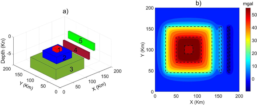
(a) 3D view of the density model, (b) gravity anomalies of the model. The dashed lines show the true edges of the prismatic sources.
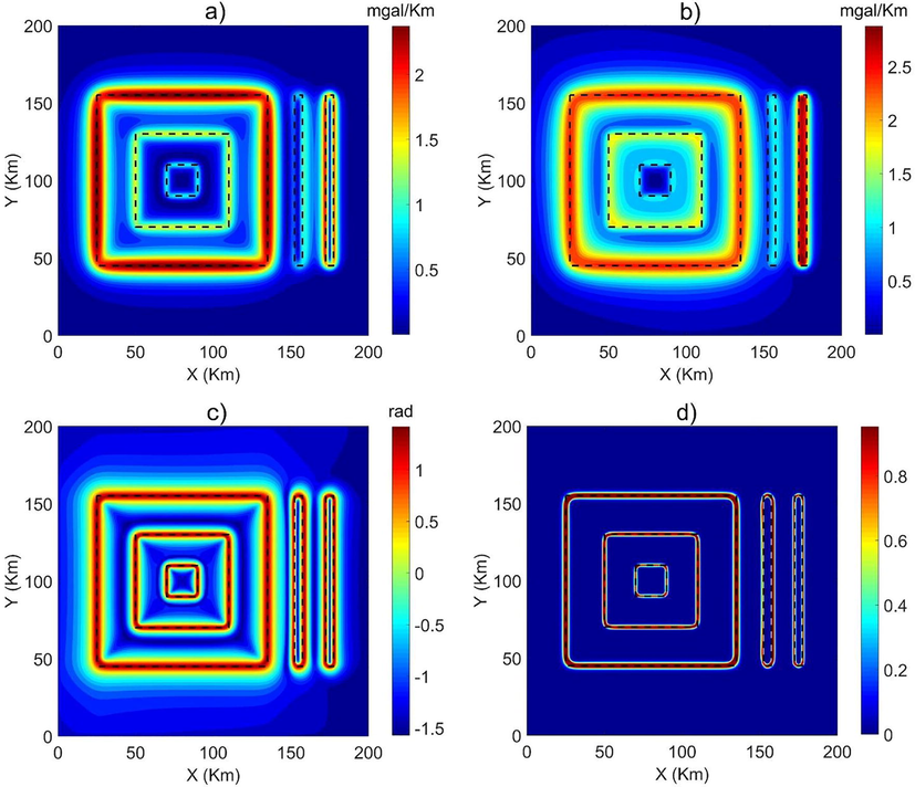
(a) Horizontal gradient, (b) total gradient, (c) enhanced horizontal gradient, (d) improved logistic. The dashed lines show the true edges of the prismatic sources.
4 Real application
The study area is a part of South Vietnam (Fig. 3), which is located in the southern part of the Indochina block. South Vietnam lies in a junction region between the Philippine, Eurasian, and Indian-Australian plates (Metcalfe, 2017). The structures in South Vietnam are obscured by Neogene-Quaternary sediments (Nong et al, 2021). There is a lack of studies on subsurface structures in South Vietnam. Interpretation of the gravity data allowed for detecting the subsurface structures of this area.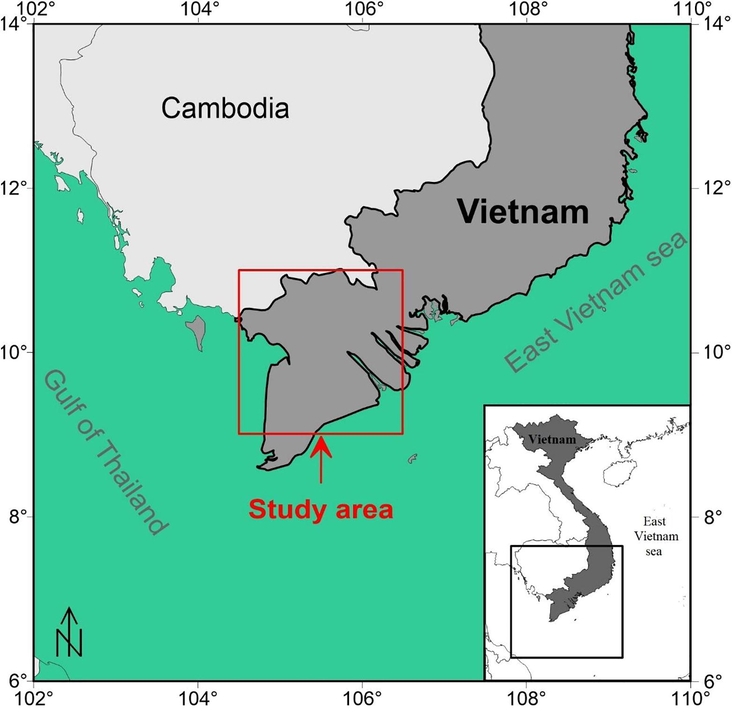
Location of the study area.
The real gravity data used in this study were obtained from the global gravity field model EIGEN6C4. The EIGEN6C4 data has a high resolution, and its error is significantly lower than the EGM2008 and EIGEN6C3 (Pal et al, 2016). This data is obtained by a combination of GRACE, LAGEOS, GOCE, and DTU10 data. Fig. 4 depicts the Bouguer gravity map after the application of corrections to free-air gravity anomaly data of the model EIGEN6C4.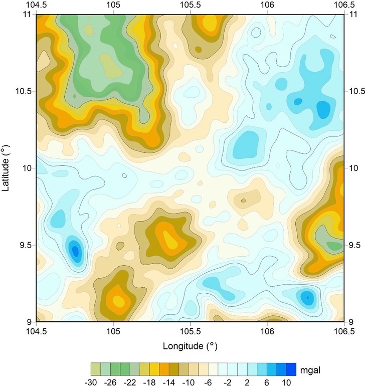
(a) Bouguer gravity map of the study area.
Here, transformation have been applied to the gravity data in (Fig. 4) to compute the horizontal gradient, total gradient, enhanced horizontal gradient, and improved logistic functions. Fig. 5a depicts the HG of the gravity data. Since the HG filter depends on the burial depth of the density structures, it cannot generate a balanced image for the lineaments of the subsurface structures. Fig. 5b depicts the TG of the gravity data. Like the HG filter, the TG method does not produce a balanced image for source edges. In addition, as shown in the synthetic model, this method tends to produce the peaks over the center of structures. Thus, it is impossible to give the true lineaments of the subsurface structures. Fig. 5c presents the lineaments detected by the TAHG method. We can see that this method is more effective in producing a clearer estimation of the lineaments than the HG and TG methods. Fig. 5d presents the lineaments determined by the IL method. Similar to the TAHG method, the IL method is a balanced detector, and therefore the detected boundaries are clearer than those obtained from the HG and TG methods. However, it is worth noting that the IL method generates a map of lineaments with higher resolution compared to the TAHG and other methods.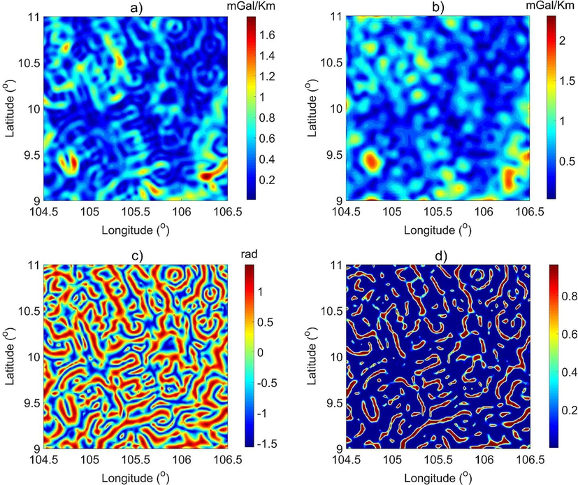
(a) Horizontal gradient, (b) Total gradient, (c) Enhanced horizontal gradient, (d) Improved logistic.
5 Discussions
It is well known that the short wavelength lineaments are mostly associated with shallower depth whereas the longer wavelength lineaments are mostly related to deep interior inside the Earth. While the HG and TG filters are dominated by the short wavelength lineaments (Fig. 5a and b), the TAHG and IL methods can delineate both the longer to smaller wavelengths structural and tectonic boundaries in the form of lineaments (Fig. 5c and d). The TAHG and IL maps indicate that several trends exist in the data, with the NW–SE and NE-SW trends being dominant (Fig. 5c and d). The obtained result also reveals circular-shaped lineaments anomaly in the Northeast region. Although the TAHG and IL filters are more effective in enhancing the gravity lineaments than the HG and TG methods, the IL generates the sharper lineaments. On the other hand, the IL peaks demonstrate the existence of many density lineaments that are obscured by Neogene-Quaternary sediments. The boundaries estimated by the IL filter are marked to locate the lineaments. Fig. 6 presents the lineaments extracted by the IL map. Fig. 7 shows the rose diagram of these lineaments. This diagram presents some main trends with the dominated lineament trends in NW–SE and NE-SW directions. The obtained results illustrate the usefulness of the IL filter for gravity field interpretation. This method equalizes the amplitudes of the anomalies due to the density structures located at different depths, making the most of the information existed in observed field data, and for qualitative studies. Although the IL filter is a good and appreciated filter, the lineaments of subsurface structures in South Vietnam need further investigation to verify that these lineaments are or are not faults.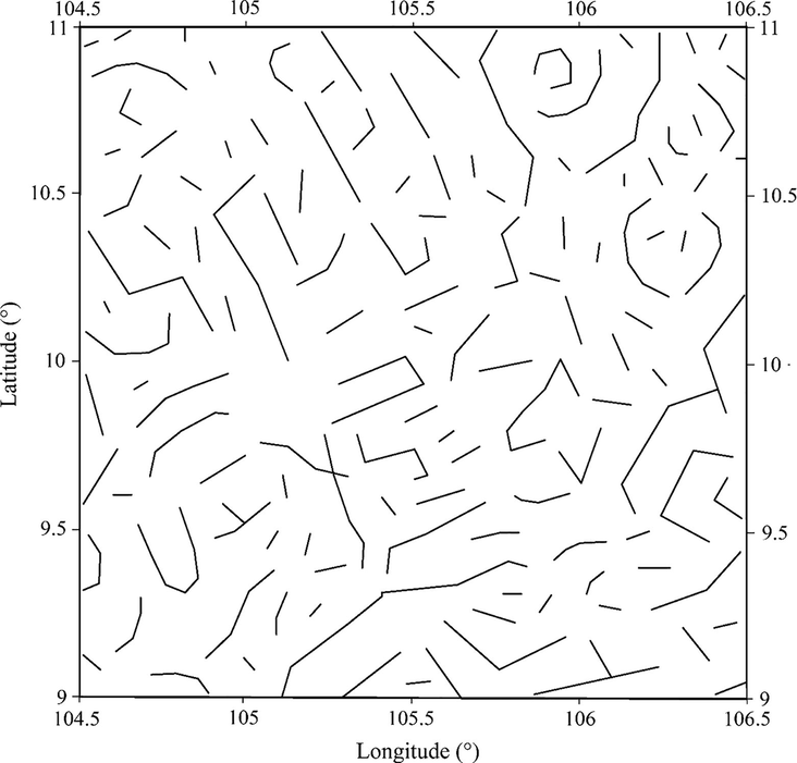
The lineaments extracted from the improved logistic map of the gravity data.
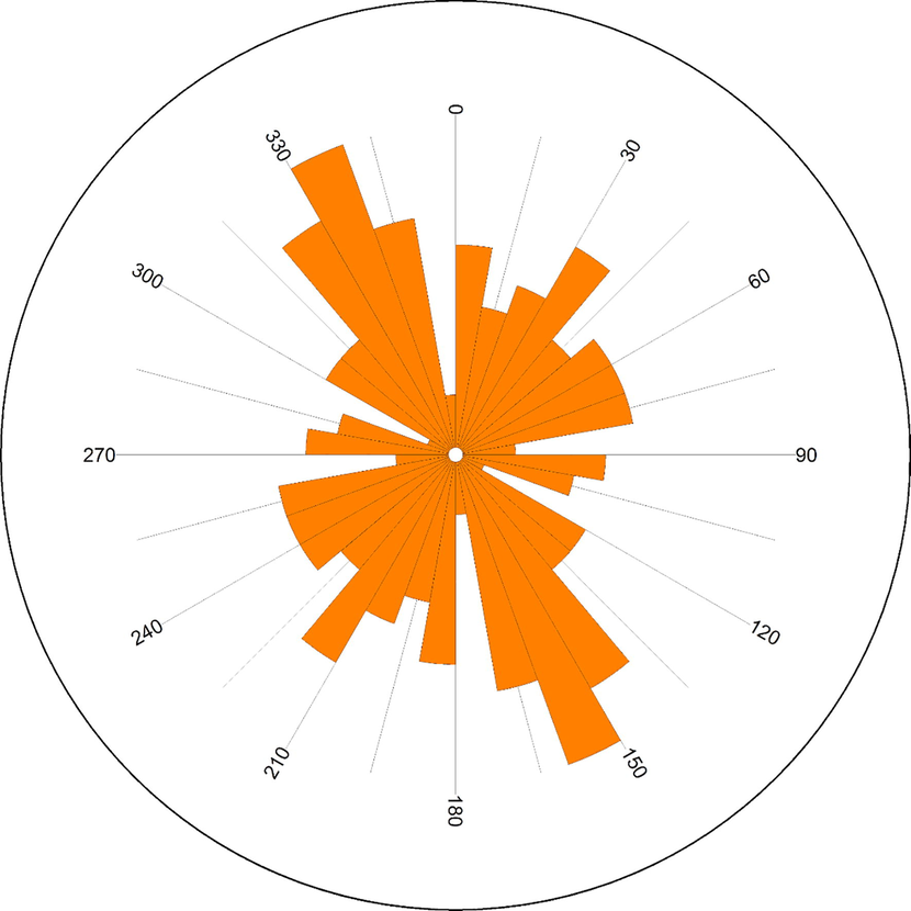
Rose diagram of the lineaments in Fig. 6.
6 Conclusions
Initially, the effectiveness of the horizontal gradient, total gradient, enhanced horizontal gradient, and improved logistic filters are tested with a synthetic gravity model. Findings show that all the edges have been estimated well using both HG, TAHG, and IL techniques. However, the edges on the IL map are more prominent than those detected by the other techniques. Further, gravity data from South Vietnam have been interpreted to extract the lineaments of the subsurface structures. The obtained results show the existence of several trends in the data, with the NW-SE and NE-SW trends being dominant. These lineaments help to increase scientific knowledge in South Vietnam, which can be used to further study within geology aims in this area. These results also indicate that the IL technique is an effective detector for lineaments detection in gravity data.
Acknowledgements
Deep thanks and gratitude to the Researchers Supporting Project number (RSP-2021/351), King Saud University, Riyadh, Saudi Arabia for funding this research article.
Declaration of Competing Interest
The authors declare that they have no known competing financial interests or personal relationships that could have appeared to influence the work reported in this paper.
References
- Enhancing potential field data using filters based on the local phase. Comput. Geosci.. 2006;32:1585-1591.
- [Google Scholar]
- Edge enhancement of potential-field data using normalized statistics. Geophysics. 2008;73(3):H1-H4.
- [Google Scholar]
- Cordell, L., Grauch, V.J.S., 1985. Mapping Basement Magnetization Zones from Aeromagnetic Data in the San Juan Basin. SEG Publication, New Mexico, pp. 181-197. doi:10.1190/1.0931830346.ch16.
- Source edge detection of potential field data using wavelet decomposition. Pure Appl. Geophys.. 2021;178:919-938.
- [Google Scholar]
- Aeromagnetic data for mapping geologic contacts at Samr El-Qaa area, North Eastern Desert. Egypt. Arab J. Geosci.. 2019;12:2.
- [CrossRef] [Google Scholar]
- Texture analysis of aeromagnetic data for enhancing geologic features using co-occurrence matrices in Elallaqi area, South Eastern Desert of Egypt. NRIAG J. Astron. Geophys.. 2018;7:155-161.
- [Google Scholar]
- Edge detection of aeromagnetic data as effective tools for structural imaging at Shilman area, South Eastern Desert. Egypt. Arab J. Geosci.. 2021;14:13.
- [CrossRef] [Google Scholar]
- Source edge detection (SED) of aeromagnetic data: synthetic examples and a case study from Haimur area, south Eastern Desert. Egypt. Arab J. Geosci.. 2020;13:626.
- [CrossRef] [Google Scholar]
- Enhancing linear features in aeromagnetic data using directional horizontal gradient at Wadi Haimur area, South Eastern Desert. Egypt. Carpathian J. Earth Environ. Sci.. 2020;15:323-326.
- [Google Scholar]
- Integrating aeromagnetic data and Landsat-8 imagery for detection of post-accretionary shear zones controlling hydrothermal alterations: The Allaqi-Heiani Suture zone, South Eastern Desert. Egypt. Adv. Space Res.. 2020;65:1008-1024.
- [Google Scholar]
- A comparative study of THG, AS, TA, Theta, TDX and LTHG techniques for improving source boundaries detection of magnetic data using synthetic models: a case study from G. Um Monqul, North Eastern Desert. Egypt. J. Afr. Earth Sci.. 2020;170:103940.
- [CrossRef] [Google Scholar]
- Enhancement of the total horizontal gradient of magnetic anomalies using the tilt angle. Geophysics. 2013;78(3):J33-J41.
- [Google Scholar]
- CURVGRAV-GUI: a graphical user interface to interpret gravity data using curvature technique. Earth Sci. Inform.. 2017;10:525-537.
- [Google Scholar]
- Improved ILTHG method for edge enhancement of geological structures: application to gravity data from the Oued Righ valley. J. Afr. Earth Sci.. 2021;177:104162
- [Google Scholar]
- Potential field tilt — a new concept for location of potential field sources. J. Appl. Geophys.. 1994;32:213-217.
- [Google Scholar]
- Geochemistry and zircon U-Pb geochronology of Late Mesozoic igneous rocks from SW Vietnam – SE Cambodia: Implications for episodic magmatism in the context of the Paleo-Pacific subduction. Lithos. 2021;390-391:106101.
- [CrossRef] [Google Scholar]
- Inverting gravity anomalies over the Burdur sedimentary basin, SW Turkey. Acta Geod. Geophys.. 2019;54:445-460.
- [Google Scholar]
- Oksum, E., Le, D.V., Vu, M.D., Nguyen, T.H.T., Pham, L.T., 2021, A novel approach based on the fast sigmoid function for interpretation of potential field data. Boll Geofis Teor Appl. doi:10.4430/bgta0348.
- EdgeDetectPFI: An algorithm for automatic edge detection in potential field anomaly images – application to dike-like magnetic structures. Comput. Geosc.. 2017;103:80-91.
- [Google Scholar]
- Structural mapping over the 85°E Ridge and surroundings using EIGEN6C4 high-resolution global combined gravity field model: an integrated approach. Mar. Geophys. Res.. 2016;37(3):159-184.
- [Google Scholar]
- A comparative study on different filters for enhancing potential field source boundaries: synthetic examples and a case study from the Song Hong Trough (Vietnam) Arab. J. Geosci.. 2020;13:723.
- [Google Scholar]
- A high-resolution edge detector for interpreting potential field data: a case study from the Witwatersrand basin, South Africa. J. Afr. Earth Sci.. 2021;178:104190.
- [CrossRef] [Google Scholar]
- Pham, L.T., Eldosouky, A.M., Oksum, E., Saada, S.A., 2020a. A new high-resolution filter for source edge detection of potential field data. Geocarto Int. doi:10.1080/10106049.2020.1849414.
- Edge enhancement of potential field data using the logistic function and the total horizontal gradient. Acta Geod. Geophys.. 2019;54(1):143-155.
- [Google Scholar]
- Enhancement of potential field source boundaries using an improved logistic filter. Pure Appl. Geophys.. 2020;177(11):5237-5249.
- [Google Scholar]
- An improved approach for detecting ridge locations to interpret the potential field data for more accurate structural mapping: a case study from Vredefort dome area (South Africa) J. Afr. Earth Sci.. 2021;175:104099.
- [CrossRef] [Google Scholar]
- An improved approach for detecting the locations of the maxima in interpreting potential field data. Arab. J. Geosci.. 2021;14:43.
- [Google Scholar]
- On the performance of phase-based filters for enhancing lateral boundaries of magnetic and gravity sources: a case study of the Seattle uplift. Arab J. Geosci.. 2021;14:129.
- [CrossRef] [Google Scholar]
- Performance evaluation of amplitude- and phase-based methods for estimating edges of potential field sources. Iran J. Sci. Technol. Trans. Sci.. 2021;45(4):1327-1339.
- [Google Scholar]
- Edge detection of potential field sources using the softsign function. Geocarto Int. 2021
- [CrossRef] [Google Scholar]
- Subsurface structural mapping from high-resolution gravity data using advanced processing methods. J. King Saud Univ. – Sci.. 2021;33(5):101488.
- [CrossRef] [Google Scholar]
- Magnetic interpretation using the 3-D analytic signal. Geophysics. 1992;57(1):116-125.
- [Google Scholar]
- Unpaired ophiolite belts in the Neoproterozoic Allaqi-Heiani Suture, the Arabian-Nubian Shield: evidences from magnetic data. J. Afr. Earth Sci.. 2019;156:26-34.
- [Google Scholar]
- Neoproterozoic hybrid forearc – MOR ophiolite belts in the northern Arabian-Nubian Shield: no evidence for back-arc tectonic setting. Int. Geol. Rev. 2020
- [CrossRef] [Google Scholar]
- Edge enhancement of potential field data using spectral moments. Geophysics. 2016;81(1):G1-G11.
- [Google Scholar]
- Digital Image Processing and analysis: Human and Computer Vision Applications with CVIPtools (2nd ed.). Boca Raton, FL: CRC Press; 2010.
- Improving a maximum horizontal gradient algorithm to determine geological body boundaries and fault systems based on gravity data. J. Appl. Geophys.. 2018;152:161-166.
- [Google Scholar]
- Verduzco, B., Fairhead, J. D., Green, C. M., and MacKenzie, C., 2004. New insights to magnetic derivatives for structural mapping: The Leading Edge.23, 116-119.
Appendix A
Supplementary data
Supplementary data to this article can be found online at https://doi.org/10.1016/j.jksus.2021.101594.
Appendix A
Supplementary data
The following are the Supplementary data to this article:


