

Translate this page into:
Geotechnical assessment for the ground conditions in Makah Al-Mukarramah city, Saudi Arabia
⁎Corresponding author at: Dept. of Geology & Geophysics, College of Science, King Saud Univ., P.O. Box 2455, Riyadh 11451, Saudi Arabia. khassanein@ksu.edu.sa (Kamal Abdelrahman)
-
Received: ,
Accepted: ,
This article was originally published by Elsevier and was migrated to Scientific Scholar after the change of Publisher.
Peer review under responsibility of King Saud University.
Abstract
In the current study, the geotechnical properties of the near-surface geological units are collected, tested, correlated, evaluated, and then mapped. In addition, the groundwater level is estimated through comprehensive geotechnical investigations conducted in and around the entire Holy city of Makkah Al-Mukarramah. Based on the measured standard penetration test (SPT), the soil materials vary from soft to very dense materials where SPT ranges from 4 to >50 and increases with depth. On the other hand, the calculated rock quality designation (RQD), the rock quality spans from very poor to good where RQD changes from 0 to 80%. Accordingly, the ground conditions of Makkah can de differentiated into eight subsoil and rock units with various geotechnical properties. Moreover, it is indicated that the physical and chemical nature of these sub-soil and rock units have a considerable effect on the foundations of the constructions that may be risky in the future. The continuous evaluation of the geotechnical and chemical properties for the future projects on these soils and even rock units is highly recommended. These results will greatly support civil engineers and urban designers in the Makkah Al-Mukarramah municipality.
Keywords
Geotechnical assessment
Chemical and physical properties
Ground conditions
Boreholes
Makkah
Saudi Arabia

1 Introduction
Makkah Al-Mukarramah is situated at an elevation of 277 m above sea level and is approximately 80 km inland from the Red Sea. Central Makkah lies in a corridor between mountainous heights. This mountainous location has defined the contemporary expansion of the city. The city centers around the Masjid Al-Haram area, which is lower than most of the city. The area around the mosque is the old city. Traditional homes are built of local rock and consists of two three stories high. The total area of Makkah today is over 1200 km2. Makkah features a hot desert climate; like most Saudi Arabian cities, Makkah retains the warm to hot temperatures even in winter, which can range from 18 °C at night to 30 °C in the afternoon. Summer temperatures are extremely hot and consistently cross 40 °C in the afternoon, dropping to 30 °C in the evening. Rain usually falls in Makkah in lesser amounts, scattered between November and January. The population density in Makkah is very high, and most long-term residents of Makkah live in the Old City, with many working in the industry known locally as the Hajj Industry. Year-round pilgrims stream into the city to perform the rites of Umrah, and during the last weeks of Dhu al-Qi‘dah, on average, 4 million Muslims arrive in the city to take part in the rites known as Hajj.
The importance of Makkah Al-Mukarramah cannot be overemphasized. However, the earthquake vulnerability of Makkah has, more than 15 years, been indicated by probabilistically predicted ground shaking levels of engineering concern. The historical records of earthquakes in Makkah, the 8 Oct. 1992 Al-Sharai‘a earthquake, the 12 Sept. 2005 non-tectonic seismic shock and the most recently 28 Nov. 2019 earthquake. In addition, the presence of the city nearby (less than 70 km) the seismically active Red Sea and its associated potentially active tectonic structures, all warrant a comprehensive seismic hazard, risk, and vulnerability assessments of Makkah.
An essential component of seismic hazard assessment is the ground motion modification of earthquake ground motion using the topmost soil cover. This modification has been known long time as amplification process is documented, and even quantified, for more than 10 decades. Its disastrous effects in many parts of the world are readily acknowledged and intensively investigated (Abdelrahman et al., 2019a). Soil amplification effects are especially important for the city of Makkah because it is mostly situated over the Quaternary alluvial deposits of Wadi Ibrahim incised into the Precambrian rocks of the Arabian Shield. The very condition of Makkah being situated within the Arabian Shield permit the efficient transmission of the earthquake body and surface waves owing to the lower crustal attenuation compared to locations where the bedrock comprises younger, more attenuating sedimentary rocks. In addition, the condition of soft, low velocity soil layers has a sharp acoustic impedance contrast with a hard, high velocity basement substratum, which increases the relative amplification of these soils to the bedrock ground motion.
It has been recognized for decades that earthquake ground motion can be significantly altered (generally amplified) by local site conditions (e.g., Milne, 1898). Near-surface acoustic impedance contrasts controlled by porosity, density, water content, etc., can significantly affect the amplitude-frequency content and duration of the earthquake ground motion emerging from the underlying bedrock. Some types of soils may amplify the ground motion by as much as 10 times its bedrock level (Borcherdt, 1970). The frequency dependence of soil amplification has been demonstrated by the amplitudes of earthquake waves recorded over soil sites peaking at specific (resonance) frequencies. This frequency is a function of the acoustic impedances and thickness of soil layers, as well as impedance contrasts at the soil bedrock.
The alluvial sediments of very fine sands resulting from the erosion of hard rocks may have environmental impact either in the form of air quality changing or human health hazard in case of the area to be exposed to severe winds (Cetin 2015, 2019; Kaya et al., 2019). Moreover, the increasing urban planning and building density of Makkah city will produce thermal climatic variations (Cetin et al., 2019).
Based on the abovementioned points, this study is oriented to differentiate the surface and subsurface ground conditions in Makkah Al-Mukarramah city through comprehensive geotechnical borehole data of 58 boreholes (Fig. 1). The physical, chemical, and mechanical properties of the ground materials including depth and geotechnical parameters of different subsurface soil formations are of utmost imprtance. Moreover, the lateral and vertical variation of ground materials will be mapped through cross-sections representing the main lithological variations of subsurface soil materials. In addition, the groundwater table level will be detected and analyzed.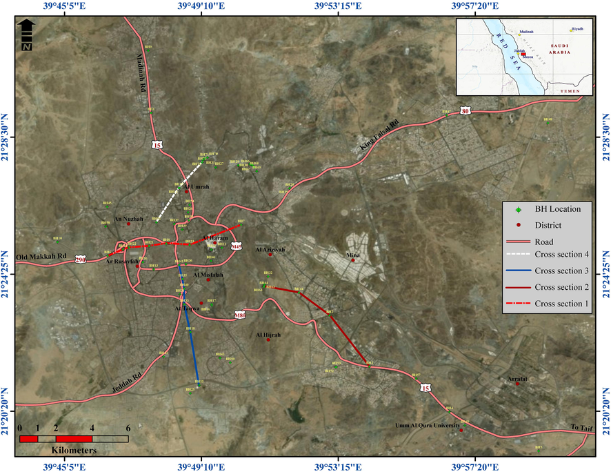
Location map for the study area and boreholes.
2 Material and methods
2.1 Geological and hydrogeological settings of Makkah
Makkah lies in the west central part of the Arabian Shield, which is structurally complex comprising features of different ages, styles, and trends. Igneous and metamorphic rocks are the two main rock units occupying the western Arabian plate of the Precambrian Shield in general, and the Makkah region in particular (Moore and Al-Rehaili, 1989). As part of Makkah batholiths, all igneous rocks range lithologically from granodiorite-tonalite and Quartz diorite, diorite, to gabbro owing to magmatic differentiation (Fig. 2). Post tectonics intrusions including younger phases of granodiorite and gabbro intruded within the Precambrian variably foliated rocks (Brown et al., 1963). The igneous rocks intruded within the metamorphic units, predominantly the amphibolites and volcano-sedimentary rocks.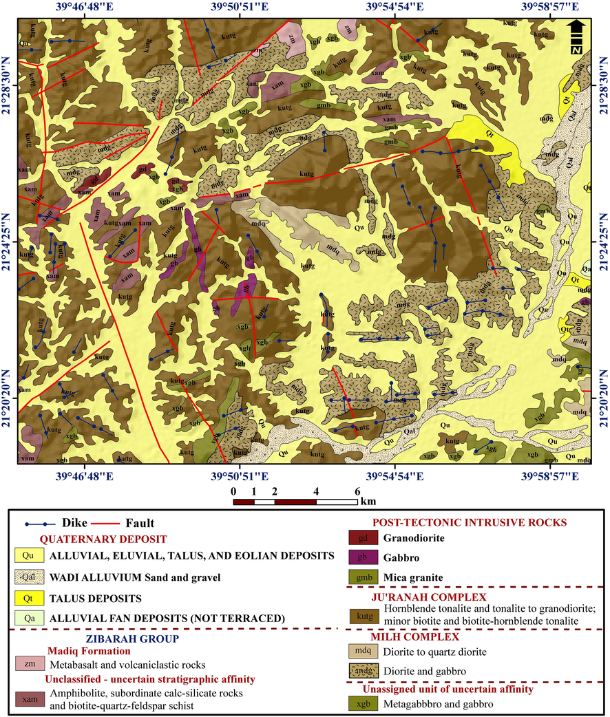
Geologic map for Makkah City.
The region experienced multiple deformations and metamorphism caused by complex tectonic events initiated by Hijaz orogeny and ended by the Red Sea Rift. The Precambrian rocks in the Makkah region are highly fractured rocks cross cut by numerous Precambrian fractures (shears, faults, and joints) of variable extensions and orientations decorating the area locally in a brecciated-like fracture pattern (Spincer and Vincent, 1984). Two major fracture trends represent the conspicuous geologic structure elements in the region. These are the NNW-SSE trend related to the Red Sea faults that initiated with the Red Sea rifting processes and the NNE-SSW to NE-SW trends that related to the transform faults, which consider the main structure elements of the Red Sea rift perpendicular to the rift axes. Most of these fracture elements are Precambrian in origin reactivated in the Red Sea rifting during the Oligocene-Miocene period.
Precambrian intrusive rocks occupy about 70% of the area and 90% of the Precambrian is available as an exposure. The plutonic rocks are unfoliated, weakly metamorphosed, and are predominantly quartz dioritic and tonalitic to granodioritic in composition. In addition, there are intrusions of gabbroic rocks. In addition to Precambrian dikes related to individual plutons, there are two types of dykes: 1) Felsic dikes that consist of tonalitic and granitic rocks and predominantly trend to the north, and others that trend to the east and northwest; 2) Mafic dikes that consist of gabbroic rocks and ore dominantly trend to the (1) east and (2) north-northwest. The Precambrian layered rocks have variably metamorphosed to grade as high as the amphibolite faces. In general, the plutonic rocks are slightly metamorphosed tertiary sediment rocks, and the younger units are unmetamorphosed.
Undifferentiated alluvial, alluvial, and talus deposits unit (QU) covers a large part of the Makkah area and consists of flood-plain alluvial deposits; however, they merge in many places with other types of quaternary deposits. In the inland drainage basin, sand and silt should spread by sheet floods from the mouths of the major wadis over older alluvial fan and terraced deposits, and they are commonly reworked by wind action. Coarse alluvial sand composed of quartz and plagioclase are concentrated in shallow depression and wades where weathered plutonic rocks readily crop out (Solami and Barakati, 2006). The region has high topographic features resulting from the uplifting associated with the Red Sea Rift. The elevations vary mainly from 300.0 m to 980.0 m (above sea level). Elevation increases and the topography tends to be rugged in the middle of the mapped area, which were dominated by high massive mountains of weakly deformed and slightly weathered rocks. Most wades in the area drain southeastward towards the Red Sea. The land surface is rocky and is sparsely vegetated. Scrubby trees and shrubs are concentrated along the major wades, where there are cultivated areas.
2.1.1 Soils and rocks in Makkah City
The importance of soil amplification effects for the seismic hazard assessment of the city of Makkah can be illustrated by inspecting the geological map of Makkah. Makkah is mostly situated over the Quaternary alluvial deposits of Wadi Ibrahim incised into the Precambrian rocks of the Arabian Shield. This is a typical situation for a significant soil amplification (Aki, 1988; Bard and Riepl-Thomas, 2000; Kawase, 2003; Boore, 2004a,b). This can be attributed to the following reasons.
First, Makkah is situated within the Arabian Shield that permits the efficient transmission of the earthquake body and surface waves owing to the lower crustal attenuation compared to locations where the bedrock is of younger, more attenuating sedimentary rocks. As shown in Fig. 2, Makkah is underlain by the Precambrian intrusive quartz diorite of the Ju‘ranah Complex, the diorite and gabbro of the Milh Complex, and the unassigned units of amphibolite and schist. These Precambrian rocks form the substratum transmitting seismic waves and delivering them to the soil column.
Second, the soft, low velocity soil layers that have a sharp acoustic impedance contrast with the hard, high velocity basement substratum that increases relative amplification of these soils to bedrock ground motion. More than 90% of the built-up area of the Makkah City is occupied by the Quaternary soft wadi and fan alluvium made up of sand and gravel, as well as talus deposits overlying the Precambrian basement. El-Dakheel et al. (1997) reported weak alluvial deposits made up of sand and gravel reaching 19 m in thickness and having Vp as low as 420 m/s in southern Makkah. Further, in the northwestern Makkah, Sonbul (1995) reported weak soil layers having Vp as low as 400 m/s and reaching thicknesses as high as 25 m obtained from seismic refraction experiments conducted at several sites. This indicates a weak soil column that might have Vs values of 250 m/s or lower and is a candidate of inducing moderate to high amplification of bedrock ground motion.
Moreover, the lithology information that collected from more than 58 boreholes drilled in Makkah all showed that weak alluvial deposits can exceed 30 m in thickness at several locations of the city and are resting on various types of basement rocks.
2.1.2 Hydrogeological setting
Historically, Makkah used a few primary sources of water. The first were local wells, such as the Zamzam Well, which produced generally brackish water. The second source was the spring of Ayn Zubayda. The sources of this spring are the mountains of J̲abal Saʿd and Jabal Kabkāb, which are a few kilometers east of Jabal Arafa or about 20 km southeast of Makkah. Water was transported from it using underground channels. A very sporadic third source was rainfall, which was stored by the people in small reservoirs or cisterns. The rainfall, scant as it is, also presents the threat of flooding and has been a danger since earliest times. According to Al-Kurdi (2007), there had been 89 historic floods by 1965, including several in the Saudi period. In the last century the most severe flood was in 1942. Since then, dams have been built to ameliorate this problem.
The groundwater table was encountered in all boreholes at a depth ranging from 0.75 to 13 m below the ground surface level. However, one standpipe piezometers were installed down to 20 m depth in the boreholes. The groundwater was measured after purging the standpipe. All groundwater levels were measured using a graduated tape with electrical water indicators in the standpipes and groundwater monitoring record. The difference in groundwater level is caused by the difference in borehole elevations. It should be mentioned that the water level is unstable and subjected to seasonal variations.
2.2 Geotechnical data collection
Geotechnical data used through this work is collected from site investigation reports of more than 80 projects completed or ongoing in 2019. These reports include common borehole logs with soil depth, description, and N-values from standard penetration tests (SPTs) as NSPT.
More than 58 boreholes were drilled through Makkah Al Mukarramah city sites to a depth that varied between 10.0 m and 30 m below the existing ground surface. The locations of these boreholes are shown in Fig. 1. The SPTs were performed in all drilled boreholes at various intervals in the alluvial deposits to obtain approximate dynamic resistance of the ground materials. The test was performed in accordance with ASTM D 1586-08a. The SPT was carried out in granular material during the drilling of boreholes. Soil samples were collected either during drilling or from the spoon sampler when performing the SPT. Rock layers are penetrated using a double-tube core barrel and rock core samples are recovered. Core recovery (REC) and rock quality designation (RQD) are measured for each core run.
2.3 Laboratory tests
Laboratory tests were performed on the recovered samples from the drilled boreholes to identify the physical and chemical properties of the ground materials. Each split-spoon sampler sample recovered was inspected, carefully placed in a plastic bag and sealed, and then labeled and placed in another plastic bag and sealed again. The testing program that followed the investigation was based on the type of the recovered samples and the applicability of the required tests. The following laboratory tests were performed on selected samples: 1) Classification and index tests: moisture content, particle size distribution and Atterberg limit; 2) Chemical tests: pH, sulphate, and chloride. The tests were performed according to American Society for Testing and Materials (ASTM) Standards and British Standards (BS).
3 Results
The drilled boreholes indicate that lithology is of one origin, which is recent (Quaternary) alluvial soil deposits, and it show that there are general similarities and continuities of the subsurface materials in spite of some local variations in gradation in both vertical and horizontal extents. These alluvial deposits are primarily composed of medium dense to very dense, light brown to brown, poorly graded sand with/without silt to poorly graded sand with/without gravel. The geological description of the ground materials at the drilled boreholes with the approximate average depths at which they were encountered are provided on logs of boreholes.
3.1 Sub-soils and rocks succession
Based on the boring logs and the inspection of the soil samples retrieved through the measurements of SPT, as well as the developed generalized stratigraphic profile (Table 1), soil stratification may be generalized into the following main layers as described below:
BH-1
Depth
Lithology
SPT
Water Level
Depth
value
0–3
POORLY GRADED SAND WITH SILT: Medium Dense to Dense, Yellowish Grey to Brown, Poorly Graded Sand with Silt, Dry.
1.5
3.018
316
3–6
POORLY GRADED SAND WITH SILT AND GRAVEL: Dense, Yellowish Brown to Grey, Poorly graded Sand with Silt and Gravel, Damp.
4.5
6.042
55
6–9
POORLY GRADED SAND: Very Dense, Yellowish Brown to Grey, Poorly graded Sand with Occasional Gravel, Damp to Wet.
7.5
66
9–10
COMPLETELY WEATHERED GRANODIORITE: Very Dense, Yellowish Brown to Grey, Poorly graded Sand with Occasional Gravel, Damp to Wet.
9.5
60
BH-02
Depth
Lithology
SPT
Water Level
Depth
value
0–4.5
POORLY GRADED SAND WITH SILT Medium Dense, Dark Brown to Grey, Poorly Graded Sand with Silt, Dry to Damp.
1.5
315
196
4.5–7.5
POORLY GRADED SAND Dense, Dark Grey to Grey, Poorly Graded Sand, Damp.
4.5
642
50
7.5–10
POORLY GRADED SAND WITH SILT Dense to Very Dense, Dark Grey to Grey, Poorly Graded Sand with Silt, Damp.
7.5
9.540
53
BH-03
Depth
Lithology
SPT
Water Level
Depth
value
0–0.1
ASPHALT LAYER Top layer is Asphalt.
4.5
0.1–1.4
ENGINEERING FILL MATERIAL Engineering Fill Material: Composed of Medium Dense, Brown, Silty Sand with Gravel, Dry.
1.5
53
1.5–4.5
POORLY GRADED SAND WITH SILT AND GRAVEL Very Dense, Brown, Poorly Graded Sand with Silt and Gravel, Dry to Damp.
3
4.550
52
4.5–6
POORLY GRADED SAND WITH SILT Medium Dense to Dense, Brown, Poorly Graded Sand with Silt, Damp.
6
58
6–10
SILTY SAND Very Dense, Brown, Silty Sand, Damp to Wet.
7.5
9.557
66
BH-27
Depth
Lithology
SPT/RQD
Water Level
Depth
Value
0–2
Pre-excavation from 0.00 to 2.00 m for utility check by Binladin.
7.4
2–3
Grey, medium dense, well-graded sand with silt and gravel of igneous origin.
2
16
3–4
Grey, dense, well-graded sand with silt.
3
36
4–5
Grey, dense, well-graded sand with silt.
4
43
5–6
Grey, medium dense, well-graded sand with silt and gravel of igneous origin.
5
45
6–7.5
Changing to very dense.
6
100
7.5–10.5
Grey, very dense, silty sand.
7.5
9100
100
10.5–12
Greenish grey medium soft to medium hard, severely weathered, intensely fractured to crushed granodirite.
10.5
100–0
12–15
Greenish grey medium hard, moderately weathered, closely to moderately fractured to granodirite
12 13.5
71 53
15–16.5
Greenish grey medium soft, severely weathered to decomposed, crushed granodirite with red clay
15
0
16.5–18
Reddish brown, soft to very soft poorly cemented mudstone (recovered as clayey sand with gravel)
16.5
0
18–19
Green, medium hard to hard, slighty weathered, intensely fractured, peridotite
18
0
19–20
Green, medium hard to hard, slighty weathered closely to moderately fractured, peridotite.
19
85
20–21
Green, medium hard to hard, slighty weathered intensely to closely to moderately fractured, peridotite
20
27
21–25
Green, medium hard to hard, slighty weathered intensely to closely to moderately fractured, peridotite.
21 22.5 24
71 43 73
BH-28
Depth
Lithology
SPT/RQD
Water Level
Depth
value
0–6
Fill material Back fill materials (silty sand with cobbles and boulders).
16.1
6–13.5
Sand Very dense, light brown, light cemented silty sand with gravel.
6
7.5
9
10.5
12
13.574
80
81
80
81
81
13.5–16.5
Weathered Rock Completely Weathered ROCK, Gray, GRANODIORITE
13.5
15100
100
16.5–25
Fractured Rock Very highly fractured rock,gray, granodiorite,very poor.
16.5
18
19.5
21
22.5
240
0
0
0
0
13
3.1.1 Fill materials
These materials are variable in composition and consistency and composed of medium dense, brown, silty sand with gravel, dry. It has 1.5 m in thickness in BH-06.
3.1.2 Silty sand with gravel
This layer has a thickness ranging from about 3.0 to 6.0 m. The layer is made up of grey, loose to very dense, silty sand.
3.1.3 Medium to very dense sand
This layer extends to a thickness of about 2.0 m. The layer is made up of grey, medium to very dense, sand.
3.1.4 Gravel with silt and sand
This layer is generally composed of grey, medium dense gravel of igneous origin with silt and sand; its thickness is 1.0 m.
3.1.5 Sand with gravel/sand with silt/sand with silt and gravel
This layer has been encountered in all boreholes with a thickness ranging between 3.0 and 10.0 m. The layer is made up of grey, loose to very dense, sand, silty sand or silty sand with gravel, sand with silt or sand with silt and gravel, and sand with gravel.
3.1.6 Weathered rock
The thickness of this layer ranges between 7.5 and 8.5 m. It is formed of medium hard, moderately to slightly weathered rock with closely to moderately spaced fractures.
3.1.7 Fractured rock
This layer is formed of greenish grey, hard, closely to slightly fractured, slightly weathered to fresh rock with thickness ranges from 1.0 to 6.0 m.
3.1.8 Massive rock
This layer has been encountered in all boreholes and extends down to the end of boreholes. It is made up of greenish grey, hard, slightly fractured, fresh rock.
3.2 Vertical and horizontal distribution
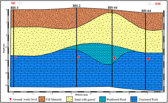
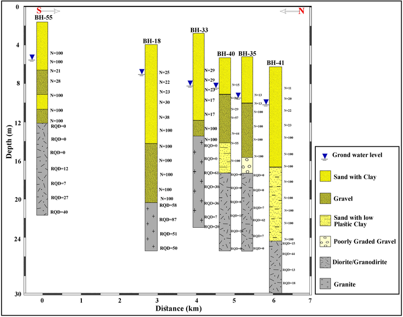
The sub-soil pattern in Makkah Al-Mukarramah are shown by five cross-sections (Figs. 3–6). These cross-sections illustrate the vertical and horizontal variation of sub-soils and rocks in the investigated area. The first cross-section runs east-west covering the central area of Makkah Al Mukarramah city (Fig. 3) indicates four soils and rock units as ground fill, sand with gravel, weathered rock, and fractured rocks. The thickness of ground fill materials ranges between 1.0 (at BH-7) to 6.0 m. Sands with the gravel layer has a thickness that varies from 12 m to 15 m. Weathered rock units appeared in BH-6 and BH-7 with the thickness of 1 m and 6.0 m, respectively. While the fractured rock unit recorded at 15 m depth at BH-5, 14 m at Bh-6, 18 m at Bh-7, and 13 m at Bh-8. The second cross-section oriented NW passing through southwestern zone of Makkah Al Mukarramah city (Fig. 4) illustrates four soils and rock layers of ground fill, sand with gravel, weathered rocks, and fractured rocks. The ground fill layer with various thicknesses where it ranges between 4 m at BH-4 to 7 m at BH-1. Sand with a gravel layer ranges between 5.0 m at BH-1 to 7.0 m at BH-4. The weathered rock layer has small thickness from 1 m at BH-1 to 2.0 m at BH-3. Moreover, the fractured rock unit is recorded at depths from 13 m at Bh-1 and 17 m at BH-3.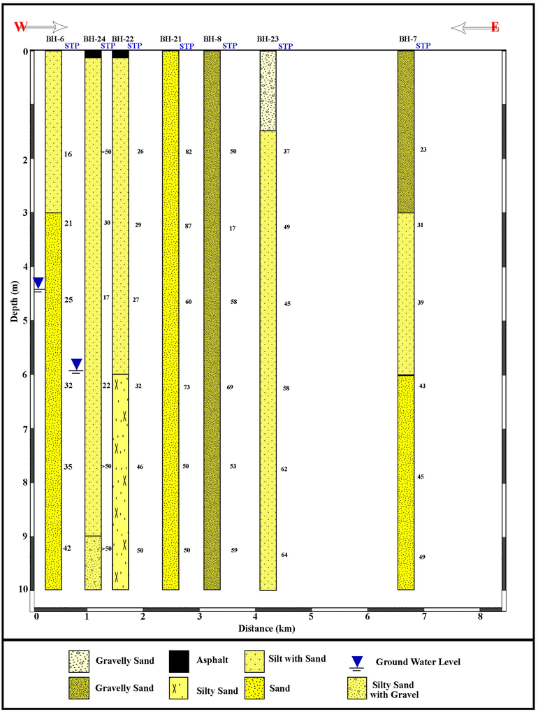
East-West cross-section-1, central area Makkah Al-Mokaramah city.
NW cross-section -2, southeastern Makkah Al-Mokaramah city.
N-S cross-section -3, southern Makkah Al-Mokaramah city.
NE cross-section -4, northern Makkah Al-Mokaramah city.
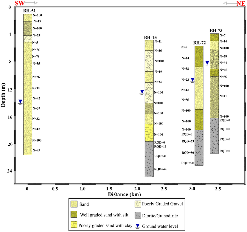
The third cross-section directed nearly N-S within the southern part of Makkah Al Mukarramah city (Fig. 5) shows seven subsoil and rock units as fill, sand, gravelly sand, silty sand, silt with sand, silty sand with gravel, and completely weathered rocks. The fill materials have 1.5 m thickness and it has been recorded at Bh-06 only. Sand layer vary in thickness between 1.5 at BH-01, 3.0 m at BH-05, BH-04, and Bh-08 but recorded at different depths. The silt with a sand layer has a greater thicknesses compared with other units where it has 4.5 m at Bh-01 and BH-05, 7.5 m at BH-08, and 1.5 m at Bh-06 at different depths. Silty sand with the gravel layer has been recorded with different thicknesses as 7.0 m at Bh-07, 3.0 m at BH-06 and BH-04, 4.0 m at BH-01, 8.5 m at BH-2, and 4.0 m at BH-03. The completely weathered rock has been recorded at a 9 m depth in BH-04; whereas the cross-section four extends NE in the northern expansion of Makkah Al Mukarramah city (Fig. 6) presents four subsoil layers as sand, silt with sand, silty sand with gravel, and gravelly sand. The sand subsoil has a 10 m thickness at Bh-12, 4.0 m at BH-10, and 7.0 m at BH-11. Sand with silt layer has 3.0 m at BH-11, 9.0 m at BH-13, 10.0 m at BH-14, 8.5 m at BH-09, and 3.0 m at BH-10. While the gravelly sand layer has 3.0 m at BH-10, 10.0 m at BH-15, and 1.0 m at BH-13; however, it is recorded at different depths through the drilled boreholes.
3.3 Chemical properties of soil
The measured pH values indicate that all foundation soils are alkaline environment where pH values are higher than 7. The sulphate contents expressed as sulfur trioxide (SO3) for the tested soil samples and ranges from 0.0374 to 0.1245%, and thus, SO4 will range from 0.0449 to 0.1494%. While chloride contents for the tested soil samples ranges from 0.0355 to 0.1135%.
The sulphate and chloride contents are higher in soils within a 5 m depth. These sulphate contents indicate aggressiveness of class 1 to 4 to concretes (BSI, 1972). These aggressive ground conditions occur in the arid and hot climate areas as in Obhor and Jeddah in western Saudi Arabia (Hossain and Ali, 1988; Abu-Hajar and Hossain, 1991).
3.4 Geotechnical assessment
According to the SPT (N value) it is indicated that; cross-section -1 indicated weak soil materials till 10 m depth where SPT less than 50. This section composed mainly of dense to very dense soil of gravelly sand, sand, silty sand and silt with sand materials; Section 2 illustrates sand with gravel of very dense soil the depth of 12 m; Section 3 reveals SPT varies from 11 to 38 reflecting medium dense materials overlay very dense deposits (SPT increased into 100); Section 4 exhibits great variation of SPT where it ranges from 7 to less than 50 suggesting soft – dense materials overlying very dense materials where SPT increased up to 100. On the other hand, the RQD estimated values for the penetrated rocks in cross-sections-2–4 reveals Very poor granodiorite (completely weathered) according to Deere (1989) where RQD varies between 0 and 25%. While the granite rocks have poor to good quality where RGQ increased from 25 up to 80% with increasing depth.
The prevalence of cohesive soils with varied strength influences all geotechnical aspects in Makkah Al-Mukarramah, and therefore, the method of estimating the cohesive soils from NSPT test should be checked in the laboratory on undisturbed soil samples. Where the classification of soil based on NSPT shows weak soil at shallow depths in the south of the Holy mosque, some areas exhibit weak soil down to a 15 m depth to the west and north-west of the city; these sites will be geotechnically problematic. Consequently, these sites treated from the engineering point-of-view before establishing the civil constructions. In addition, the strength and compressibility should be assessed in areas where rocks are encountered.
The British Standard, BSI (1972) stated requirements for concrete exposed to the sulphate attack depending on the concentration of the sulphate in the surrounding soil or in water. These requirements state the type of cement to be used, the minimum cement content, and the maximum free water to cement ratio. Based on the measured sulphate contents of the ground materials, the tested samples are classified as Class 1 where no special requirements concerning the cement type and content and the water-to-cement ratio for class (1) are recommended. The classification of the site on the basis of the sulphate level can be determined according to building research establishment (BRE). However, modifications to this classification should be made by the designers once the type of exposure to sulphate (such as types of floors exposures, static ground water and permeability of soils, the location and thickness of the structure and the hydrostatic head), and the types of concrete used (such as precast concrete, cast-in-situ concrete, wall units, and piles) are finally determined. The chloride content for the tested soil samples ranges from 0.0355 to 0.1135%.
4 Conclusions
The Makkah urban area has been founded on the Quaternary alluvial deposits, which varies in the mechanical and geotechnical properties. The ground conditions through the urban area has been evaluated in this study through the collected borehole data from different authorities for several projects. Eight sub-soil and rock units have been assigned and should be considered before constructions. The fill materials represent the topmost layer that extends all over the investigated area, while the massive rocks are recorded at the end of boreholes at the boring sites. The higher contents of sulphate and chloride in the soil have to be considered through the selection of cement type for foundation concrete and reinforcement. It is highly recommended that; the groundwater table should be monitored continuously in the new site investigations to avoid the heave from post-constructional wetting especially when the structure established on dry clay deposits.
Acknowledgements
Deep thanks and gratitude to the Researchers Supporting Project number (RSP-2019/14), King Saud University, Riyadh, Saudi Arabia for funding this research article.
Declaration of Competing Interest
The authors declare that they have no known competing financial interests or personal relationships that could have appeared to influence the work reported in this paper.
References
- Ground motion acceleration and response spectra of Al-Mashair area, Makkah Al-Mukarramah, Saudi Arabia. Arab. J. Geosci.. 2019;12(11)
- [CrossRef] [Google Scholar]
- Ground condition in Jeddah and its influence on selection and design of foundation. J. KAU, Earth Sci.. 1991;4:45-66.
- [Google Scholar]
- Al-Kurdi, A., 2007. Historic cities in the Islamic world, Bosworth E., Brill K.N.V. (Eds.), Hotei Publishing, Netherlands.
- Aki, K., 1988. Local site effects on strong ground motion. In: Earthquake engineering and soil dynamics II–Recent advances in Ground Motion Evaluation, J.L. von Thun, (Ed.), Geotechnical Special Publication No. 20, Am. Soc. Civil Eng. 103–155.
- Wave propagation in complex geological structures and their effects on strong ground motion. In: Kausel E., Manolis G., eds. Wave Motion in Earthquake Engineering, E. Southampton, Great Britain: WIT Press; 2000. p. :37-95.
- [Google Scholar]
- Estimating Vs (30) (or NEHRP Site Classes) from shallow velocity models (depths < 30 m) BSSA. 2004;94:591-597.
- [Google Scholar]
- Brown, G.F., Jackson, R.O., Bogue, R.G., MacLean, W.H. 1963. Geology of the Southern Hijaz quadrangle, Kingdom of Saudi Arabia: Saudi Arabian directorate general of mineral resources, Miscellaneous Geologic investigations MAP I–210 A, 1: 500,000 scale.
- CP 2004: 1972, Code of Practice for Foundations. London: British Standard Institution; 1972. p. :158.
- Using GIS analysis to assess urban green space in terms of accessibility: case study in Kutahya. Int. J. Sustainable Dev. World Ecol.. 2015;22(5):420-424.
- [Google Scholar]
- The effect of urban planning on urban formations determining bioclimatic comfort area’s effect using satellitia imagines on air quality: a case study of Bursa city. Air Qual. Atmos. Health 2019:1-13.
- [CrossRef] [Google Scholar]
- Evaluation of thermal climatic region areas in terms of building density in urban management and planning for Burdur, Turkey. Air Qual. Atmos. Health. 2019;12(9):1103-1112.
- [CrossRef] [Google Scholar]
- Rock Quality Designation (RQD) After 20 Years, U.S. Army Corps Engrs. Contract Report GL-89-1. Vicksburg, MS: Waterways Experimental Station; 1989.
- El-Dakheel, AR.M., Sadek, H.S., El-Saeed, M.M., Filali, E.Y., 1997. Groundwater resources in Misfalaf area – Southern Makkah Al Mukarramah. MW-17-50, Fakeeh Center for R&D, 201 (in Arabic).
- Shear strength and consolidation characteristics of Obhor Sabkha, Saudi Arabia. Q. J. Eng. Geol. London. 1988;21:347-359.
- [Google Scholar]
- Site effects on strong ground motions. In: Lee W.H.K., Kanamori H., Jennings P.C., Kisslinger C., eds. International Handbook of Earthquake and Engineering Seismology. Academic Press; 2003. p. :1013-1030.
- [Google Scholar]
- Spatial data analysis with R programming for environment. Human Ecol. Risk Assess.. 2019;25(6):1521-1530.
- [CrossRef] [Google Scholar]
- Moore, T.A., Al-Rehaili, M.H. 1989. Geologic map of the Makkah Quadrangle, sheet 21D, Kingdom of Saudi Arabia. Saudi Arabian Directorate General of Mineral Resources, Geoscience Map GM-107C, Scale 1:250,000, with text, 62p. Jeddah, Saudi Arabia.
- Solami, A., Barakati, G. 2006. Engineering geological mapping of the holy city of Makkah Al Mukarramah, Saudi Arabia. The 10th IAEG International Congress, Nottingham, United Kingdom, Paper number 552.
- Engineering Geology as Applied to Urban Development of the North-western Area of the Holy City of Makkah. King Abdul-Aziz Univ.; 1995. p. :138. M.Sc., Faculty of Earth Sci.
- Spincer, C.H., Vincent, P.L. 1984. Bentonite resource potential and geology of the Cenozoic sediments, Jeddah region: Saudi Arabian Deputy Ministry for Mineral Resources, Open-File Report BRGM-O-F-02-34, 34 p.


