

Translate this page into:
Geophysical assessment of open dumpsite nearby Khamis Mushait industrial zone, Southwestern Saudi Arabia
⁎Corresponding author. 438105491@student.ksu.edu.sa (Ahmed Nasser Aldossari)
-
Received: ,
Accepted: ,
This article was originally published by Elsevier and was migrated to Scientific Scholar after the change of Publisher.
Peer review under responsibility of King Saud University.
Abstract
Vertical electrical soundings, seismic refraction tomography, and ground magnetic measurements were taken or conducted close to an open dumpsite near Khamis Mushait, southwestern Saudi Arabia, which is characterized by shallow groundwater conditions. Structurally, intersected series of north- to northwest-trending faults affect the area. A new urban expansion and the Khamis Mushait industrial zone are close to the open dumpsite. This study evaluates the potential for leachate intrusion into groundwater aquifers. The results of electrical soundings reveal four geoelectric units: the topsoil, weathered layer, partly weathered/fractured basement, and fresh basement bedrock. At the dumpsite, relatively low resistivity values that are less than 30 Ωm characterize the topsoil, weathered layer, and partly weathered/fractured basement because of conductive leachate from the dumpsite. Besides, the results of ground magnetic data indicate that the deformation of varying intensities affects the dumpsite area, resulting in fractures developing in the N–S, NE–SW, NW–SE, and, to a lesser extent, E–W directions. Moreover, geoseismic tomographic models illustrate a low P-wave velocity zone corresponding to a low resistivity zone, and a NE–SW fault was identified from geoseismic cross-sections. Finally, these fractures and faults could become contaminant pathways for shallow aquifers around the dumpsite. To minimize the impact of such leachate, from a dumpsite, on groundwater quality and the environment in general, the dumpsite must be properly designed, constructed, and managed using engineering principles.
Keywords
Seismic tomography
Vertical electrical sounding (VES)
Magnetic
Khamis Mushait
Saudi Arabia

1 Introduction
The health hazards and environmental impact associated with the open dumping of waste has been studied at various sites globally (Porsani et al., 2004; Karlık and Kaya, 2001; Benson et al., 1997; Mukhtar et al., 2000; Klinck et al., 1995). Near-surface geophysical measurements provide an economic and nondestructive way to investigate contaminant plumes from landfills (Cahyna, 1990; Carpenter et al., 1990; Ross et al., 1990). However, indications exist that the leachates generated at dumpsites continue to affect the environment. The geometry delineation of the pollution plume and its migration path in the area around the dumpsite are necessary to facilitate rehabilitation and remediation processes where necessary. Geophysics has some major advantages, making it suitable for environmental impact assessment. It is noninvasive, nondestructive and can give continuous subsurface information for a profile.
Consequently, geophysics is critical for contaminated land assessment. Several authors (Benson et al., 1997; Adepelumi et al., 2005; Ehinri et al., 2009; Obase et al., 2009; Alile et al., 2011; Bayode et al., 2012) have used geophysical methods, such as seismic tomography, electromagnetic, and electrical resistivity measurements in mapping dumpsite pollution in basement complex terrains (Sunmonu et al., 2012; Abdullahi et al., 2013; Raji and Adeoye, 2017). In this study, seismic tomography, geoelectric, and land-magnetic measurements have been conducted to investigate the environmental impact of the dumpsite. The dumpsite hosts many inhomogeneous materials that are largely nonbiodegradable, allowing a long-term interaction between dumpsite materials, soil, and subsurface geological units. Waste disposed into landfill sites undergoes oxidation, corrosion of metallic components, and decomposition of organic matter, generating and releasing leachates that can affect the soil, surface, and groundwater resources and affecting the potability of underground water.
Because of the industrial development of the Khamis Mushait area and the increasing urban population, various wastes are produced daily and deposited at a nearby dumpsite. The waste is dumped intensively and daily, posing an environmental hazard to the surrounding area. This site passes through a group of small tributaries that flow into the main path of the main wadi channel passing through the area, separating the industrial zone from the dumpsite. Therefore, the Wadi receives excessive pollutants daily, either from the waste dump or the large industrial area, indicating intensive environmental pollution. Furthermore, the groundwater near this Wadi could be contaminated by leachate from the deposited waste (Bernstone and Dahlin, 1996; Hensel and Dalton, 1995).
The dumpsite is oriented northwest, and the waste area is divided into two parts, one for solid waste in the southwestern part and the other for liquid waste in the north. The dumpsite receives significant quantities of waste daily (Fig. 1). Some are partially treated, especially liquid, whereas solid waste is untreated, reflecting the seriousness of waste on the surrounding soil and environment and, consequently, on the residents of the area. This study, therefore, reveals subtle features and structures within the underlying rock that can function as contaminant pathways using near-surface geophysical methods.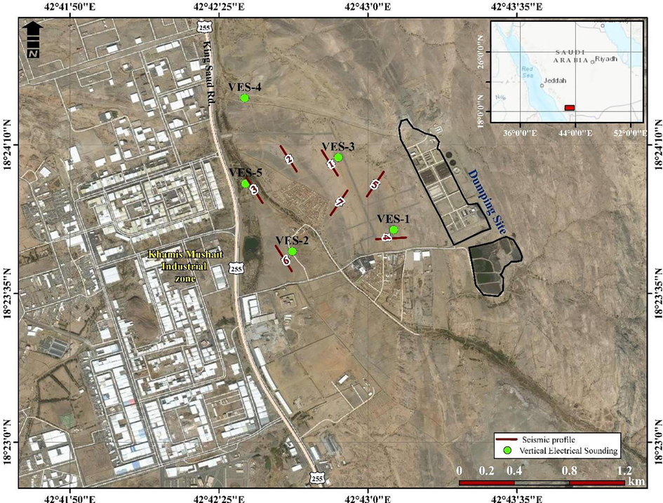
Location map of the dumpsite and the selected VES and seismic refraction sites.
2 Geology and hydrogeology
Upper Proterozoic metamorphosed volcanic and sedimentary rocks underlie the dumpsites of Baish, Baha, Jiddah, and Halaban groups and by upper Proterozoic plutonic rocks ranging in composition from gabbro to granite (Greenwood, 1985). Tertiary–Quaternary basalt and Quaternary surficial deposits overlie the Proterozoic rocks (Fig. 2). The area’s rocks are structurally stable, although a system of joints and fractures exist in the area, where biotite granodiorite and monzogranite (gdn) rocks are strongly foliated and form much of what was mapped as Khamis Mushait gneiss (Coleman, 1973; Coleman et al., 1972; Nassief et al., 1990; Johnson, 2006). These joints and fractures could serve as migration channels for leachates (pollution plumes) to establish contact with the environment.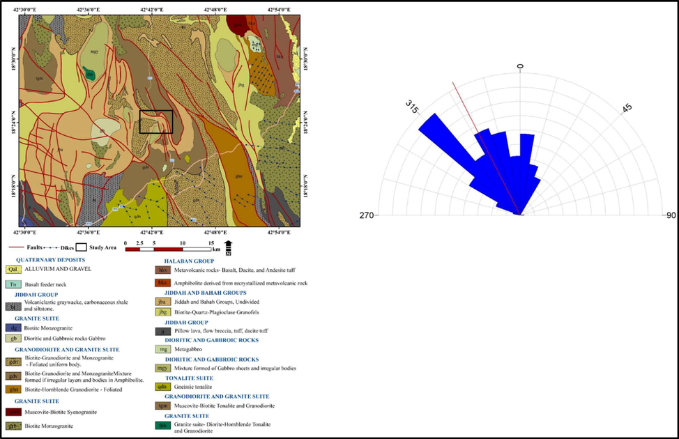
Geologic map for the study area with the affecting surface structures.
The ground around the dumpsite slopes toward the main path of the Wadi. On the western side of the dumpsite is a small stream, flowing southeast. Drainage in and around the dumpsite flows into a small stream that discharges its waters into the main course of the Wadi. The study area lies within a fourth-order sub-basin with a stream flowing SE–NW. The drainage basin occupies 79.35 km2 and has a perimeter of 46.895 km. The relief within the drainage basin ranges from 1917 to 2040 m above mean sea level. The relatively straight path of the third- and fourth-order streams, as seen on the map, (Fig. 3) shows that the streamflow is structurally controlled. The average basin slope is 5.35%. (Fig. 4). The basin drainage density is 1.028, indicative of a coarse drainage network that, in turn, reflects the surface geological conditions. The fractured and weathered basement rocks facilitate the infiltration of rainwater rather than surface runoff.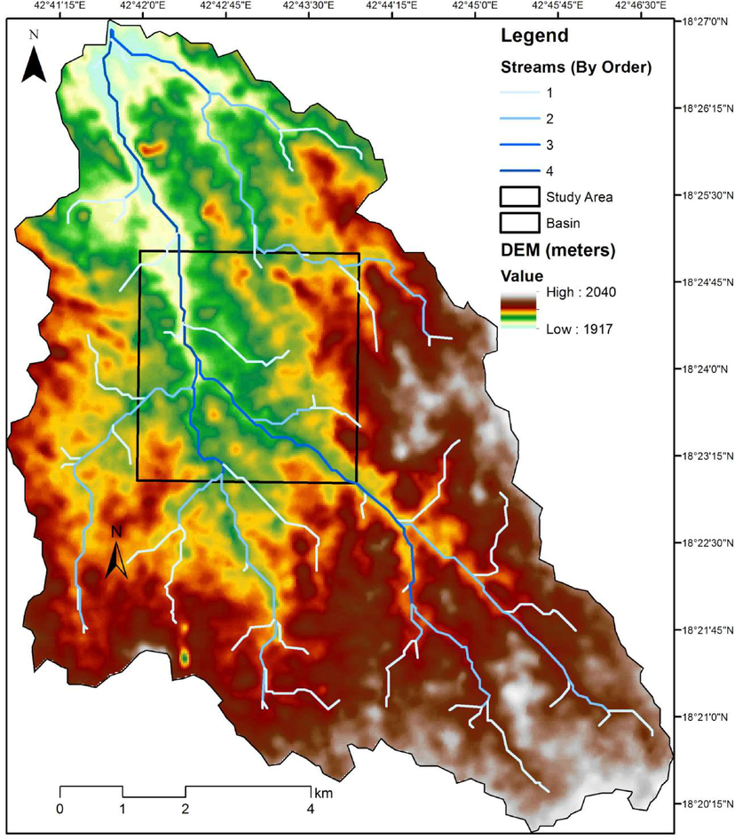
Hydrogeological basin analysis around the dumpsite area.
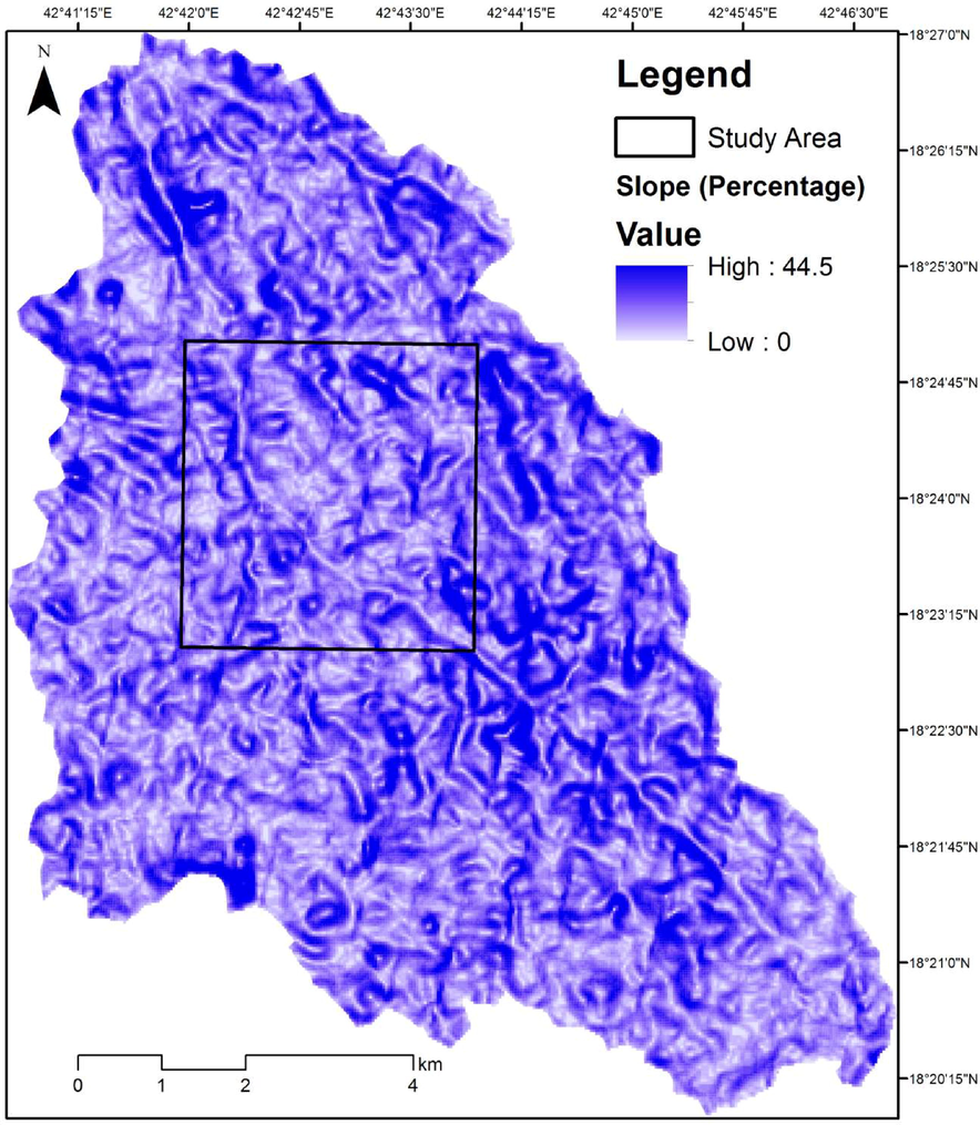
The average slope of the basin.
Groundwater is found in the weathered layer, faults, fractures, and jointed basement column. The weathered layer in the study area is thin because of the shallow depth of bedrock. Therefore, subsurface structural discontinuities (shear zones, fractures, and joints) are targeted for productive boreholes in the study area.
Zaki (2009) investigated the physicochemical parameters in water samples (bottled water, desalinated water from public water supplies, and groundwater) in Khamis Mushait. The analyzed parameters included TDS, total hardness, chloride, sulfate, nitrate, and heavy metals, such as iron manganese, copper, and zinc. The graph shows a comparison of the mean values obtained for these parameters from bottled, desalinated, and groundwater. The average values of all analyzed parameters were the highest in the groundwater samples (Fig. 5).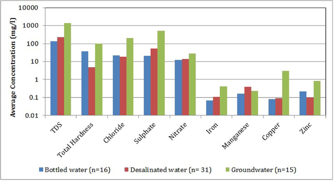
Groundwater quality in Khamis Mushait area (after Zaki, 2009).
3 Geophysical data acquisition and analysis
Electrical resistivity, seismic refraction tomography, and ground magnetic surveys as near-surface geophysical techniques were used at the Khamis Mushait dumpsite. These methods were applied at several sites globally for detecting subsurface groundwater pathways.
The electrical resistivity method was adopted for the survey because of its response to water-bearing materials, indicating the resistivities and conductive nature of underground layers. Five vertical electrical sounding (VES) measurements were acquired at the dumpsite using the Schlumberger array with a maximum current electrode spacing of 150 m (Fig. 1). Field measurements have been taken using a Syscal R2 instrument. The apparent resistivity data obtained from the VES survey were presented as depth-sounding curves by plotting the apparent resistivities along the ordinate axis and the half current electrode spacing (AB/2) along the abscissa. The VES curve results (Fig. 6) obtained from the partial curve matching were used to constrain the interpretation using IPI2win iteration software (http://geophys.geol.msu.ru, 2003).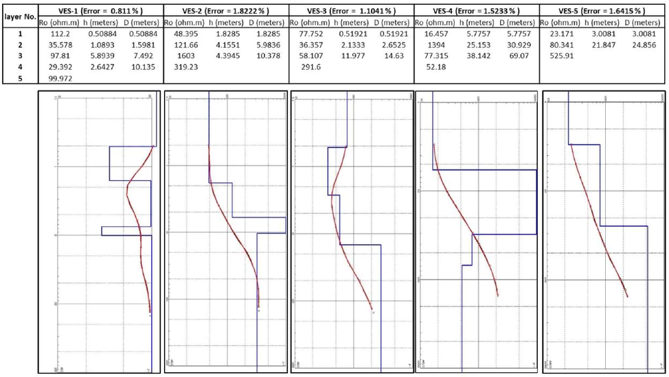
The depth Sounding Curve for VESes.
Moreover, a portable cesium vapor magnetometer (Geometrics cooperation) was used for the magnetic survey at the dumpsite to measure the total magnetic field intensity (TMI). The direction and orientation of profile lines were determined using a silver compass/GPS. The survey profile lines trend N–S and E–W. An intersected regular net of profile lines was laid with a nominal line spacing of 150 m and a nominal station spacing of 20 m. GPS readings were taken at the start and end of each profile line. The profile length ranged between 220 and 620 m, depended on site accessibility from both directions. A magnetic base station was established at the first station of each profile line. Total field readings and time were measured every 20 min on the high pole position. Finally, the regional field was backed out using the first base station total magnetic value. The data were processed using Geosoft Oasis Montaj 6.4.2 software. Sequences of filters and corrections have been applied for TMI data (Fig. 7) and reduced to pole to detect the subsurface structures or lineaments affecting the main course of the Wadi (Fig. 8).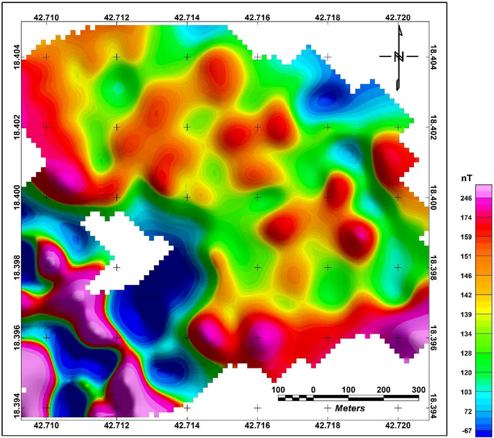
The Total Magnetic Field Intensity (TMI) map for the wadi.
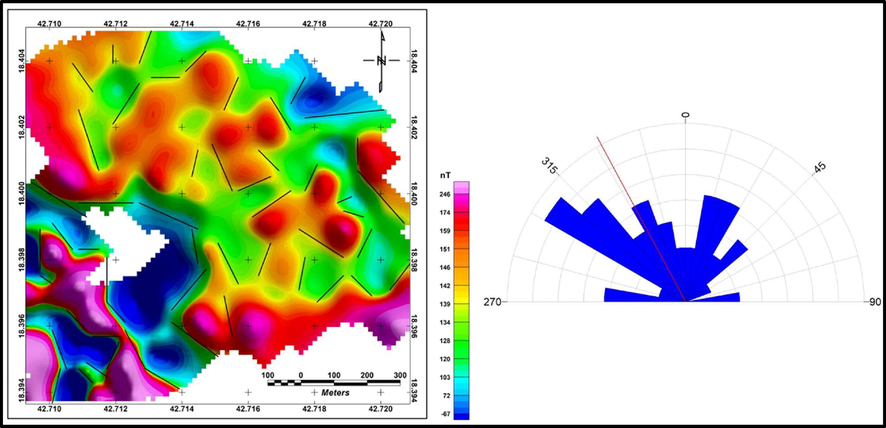
The detected subsurface faults affecting the dumpsite area from the Reduced To the Pole (RTP) magnetic map.
Furthermore, a seismic refraction (SR) survey was conducted on seven profiles on the dumpsite (Fig. 1). Each profile was 115 m long and comprised a 24-geophone array of 4.5-Hz geophones at 5-m spacing. A Geode seismograph with high-speed analog-to-digital (A/D) converters was used in this survey. A 10-kg sledgehammer hitting a striker plate was used as the energy source, which is appropriate when the ambient noise is low. Five shot points were distributed along the profile, namely, two offset shots, a forward shot, a midpoint shot, and a reverse shot (Fig. 9). Seismic data with higher signal-to-noise (S/N) ratio and superior quality were recorded in the field using multiple stacks at each shot point.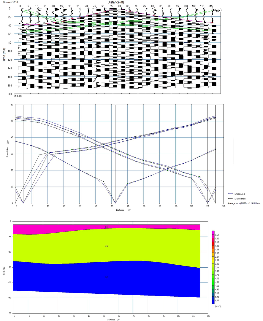
The first break picking, Traveltime-distance curve and the ground model for line No. 6 seismic refraction.
Furthermore, SR tomographic data were collected using the Geode seismograph on the same profiles of the resistivity surveys to detect and delineate subsurface structures that can function as contaminant pathways. The geophones were laid out at an interval of 5 m, and seismic energy was sent into the ground using a 10-kg hammer blow on a base plate. A shot was taken at every geophone after adjusting the equipment for this mode to have dense data. The collected SR and SR tomographic data from the field were subjected to varying stages of processing using SeisImager software (Geometrics. com, 2009) to enhance the S/N ratio. Applying the bandpass frequency filtering process improved the quality of the real signal after the noise was filtered out. Fig. 10 shows the first-break picking, travel time–distance curves, and the subsurface ground model for profile No. 6.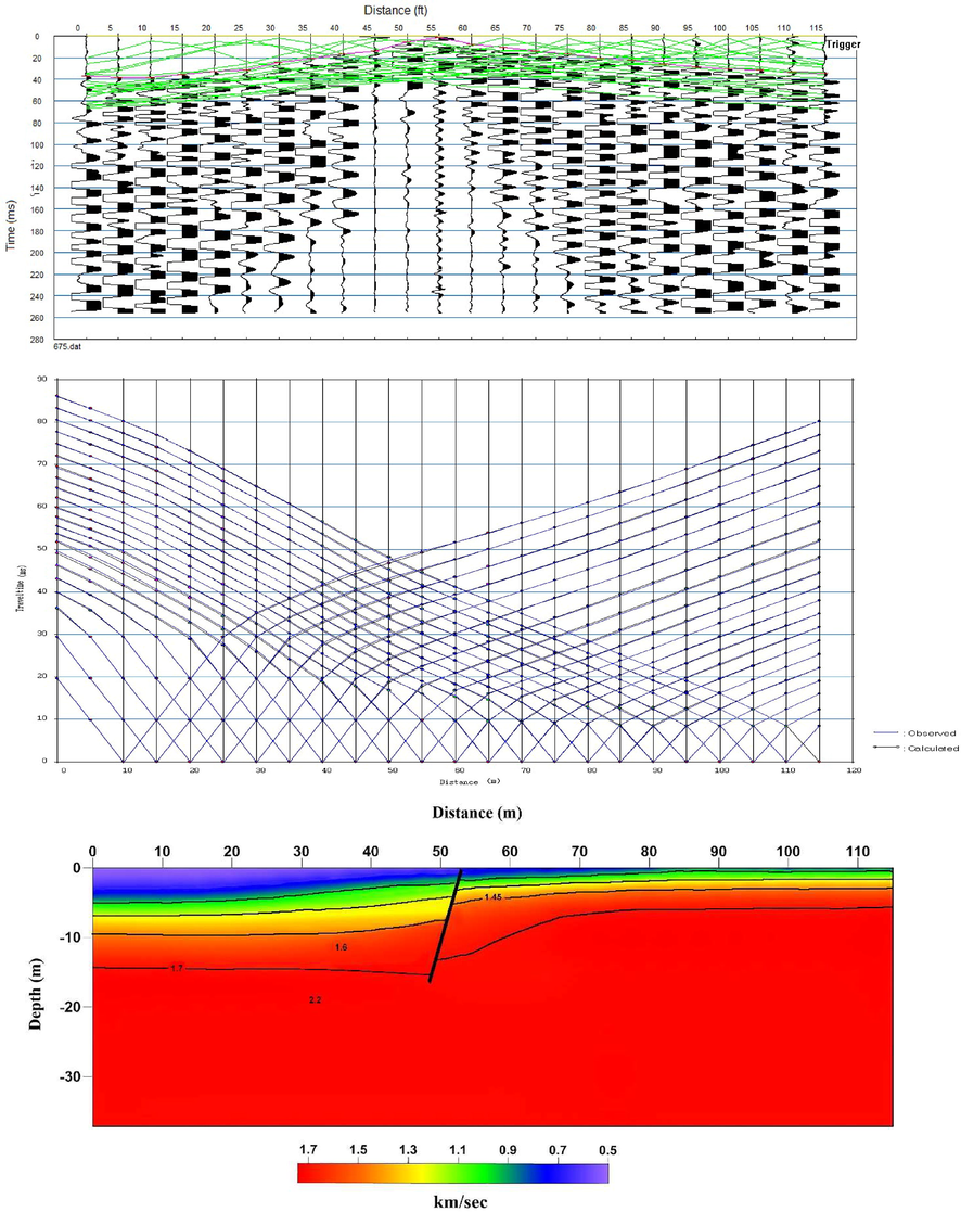
The first break picking, Traveltime-distance curve and the ground model for line No. 6 seismic refraction tomography.
4 Results and discussion
As can be seen in Fig. 6, the VES results for the main course of the Wadi (VES-2, VES-4, and VES-5) show four distinct layers, namely, topsoil, lateritic clay, weathered layers, and fresh basement. The topsoil had resistivities ranging from 16.45 to 48.39 Ωm to a depth of 1.8–5.7 m. The second layer, characterized by lateritic clay, had resistivities ranging from 80.34 to 1394 Ωm to a depth of 5.98–30.9 m. The weathered layer had resistivities ranging from 77.31 to 1603 Ωm to a depth of 10.37–69.07 m, and the fresh bedrock had resistivities ranging from 25.18 Ωm to ∞. However, VESs close to the dumpsite (VES-1 and VES-2) illustrate four layers with velocities of 77.75–112.2, 35.57–36.35, 58.97–97, and 29–291 Ωm, respectively. Therefore, the only promising water-bearing horizon is the weathered zone. The resistivities increase toward the main course of the Wadi. However, the increase in the resistivity of the water-bearing horizon away from the dumpsite indicates groundwater pollution by leachates from the dumped waste.
Fig. 10 shows the corresponding SR inverse model along profile No. 6. The results of the seismic survey reveal a thick overburden of 2–6 m, representing the topsoil saturated with water, where it has a low P-wave velocity (500 m/s), whereas the second layer extends to a 30-m depth, which is a water-bearing weathered zone or a fracture in the basement rocks with moderate P-wave velocity (3000 m/s). Furthermore, the higher P-wave velocity (5800 m/s) represents fresh basement rocks. The seismic wave velocity decreases outside the waste dump, indicating that the groundwater pollution by leachates increases away from the waste dump.
Furthermore, the ground magnetic survey clarifies that different sets of faults affected the area and oriented NNW–SSE and NNE–SSW. These faults reveal that the area is subjected to sequences of tectonic activities with different magnitudes and directions. These faults and fractures could function as contamination pathways from the dumpsite toward the main course of the Wadi.
5 Conclusions and recommendations
Three near-surface geophysical methods have been used to evaluate the environmental impact of the dumpsite close to Khamis Mushait industrial area. The acquired data, which were analyzed and processed illustrate pollutant leakage from the dumpsite toward the principal stream path. The results come from the low resistivity values that increase toward the main Wadi. The results were confirmed from SR profiles in which the subsurface structures showed the upper soil, which has a low velocity; a medium-velocity layer, which reflected a layer of broken surface representing the water-bearing layer in the region; and a third layer with higher seismic velocity, which is a layer of solid and fresh basement rocks. We noticed that the velocity decreases away from the dumpsite, confirming waste leaking into the Wadi.
The geophysical investigations conducted in this study match the water quality investigation of Zaki (2009). The highly fractured bedrock, as inferred from the geophysical investigation and basin morphometric parameter studies, facilitate the point sources of pollution (septic tanks and untreated sewage waste disposal in the city) to quickly reach the groundwater table, polluting this natural resource.
This study shows that dumpsite leachates constitute a serious hazard to the local aquifer. The impact of such leachates on groundwater quality and the environment can be minimized by properly designing, constructing, and managing dumpsite facilities using engineering principles to prevent pollution. Regular monitoring of groundwater in that region is required and essential for a longer period to verify the influence of seasonal variations on contaminant concentrations. Waste disposal sites should be situated far away from inhabited areas and be properly treated before disposal. Regulations, including proper design and construction of septic tanks, should be made mandatory to avoid contamination of groundwater resources.
Acknowledgments
The authors extend their appreciation to the Deanship of Scientific Research at King Saud University for funding this work through research group No. RGP-1438-059.
Declaration of Competing Interest
The authors declare that they have no known competing financial interests or personal relationships that could have appeared to influence the work reported in this paper.
References
- Delineation of contamination plume around oxidation sewage-ponds in southwestern Nigeria. Environ. Geol.. 2005;48(8):1137-1146.
- [Google Scholar]
- Abdullahi, N.K., I.B. Osazuwa, P. O. Sule, A. Onugba (2013). Geophysical Assessment of an Active Open Dump site in Basement Complex of Northwestern Nigeria. International Journal of Engineering Science Invention, Volume 2 Issue 5, PP-12-21.
- Geoelectric investigation and hydrochemical analysis of groundwater in a waste dump environment, Isolo, Lagos. Afr. J. Environ. Sci. Technol.. 2011;5(10):795-806.
- [Google Scholar]
- Integrated geoelectric and hydrochemical investigation for environmental impact assessment of the area around some ancient dumpsite in akure metropolis, Southwestern Nigeria. Pacific J. Sci. Technol.. 2012;13(1):700-713.
- [Google Scholar]
- Mapping groundwater contamination using DC resistivity and VLF geophysical methods —A case study. Geophysics. 1997;62(1997):80-86.
- [Google Scholar]
- Bernstone, C. and Dahlin, T. (1996). 2D Resistivity Survey of old Landfills. Procs. 2nd European EEGS Meeting, Nantes France, 2-4 September 1996, 188-191.
- Cahyna F. (1990). Monitoring of artificial infiltration using geoelectrical methods. In: Ward SH (ed) Geotechnical and Environmental Geophysics. vol II. SocExpl Geophysicists1990, 101–106.
- Use of resistivity soundings to determine landfill structure. Ground Water. 1990;28(4):569-575.
- [Google Scholar]
- Coleman, R. G., (1973). Reconnaissance geology of the Khamis Mushayt quadrangle, Kingdom of Saudi Arabia: Saudi Arabian Directorate General of Mineral Resources Geologic Map GM-5, 6 p., scale 1:100,000.
- Coleman, R. G., Brown, G. F., and Keith, T. E. C., (1972). Layered gabbros in southwest Saudi Arabia: U. S. Geological Survey Professional Paper 800-D, p. D143-D150.
- Geophysical and hydro-physiochemical study of the contaminant impact of a solid waste landfill (SWL) in port Harcourt Municipality, Nigeria. Pacific J. Sci. Technol.. 2009;10(2):579-603.
- [Google Scholar]
- Geometrics. Com, SeisImager/2DTM Manual Version 3.3 Pickwin v. 4.0.1.5 Plotrefa v. 2.9.1.6 2009.
- Hensel, E. and Dalton, K.E. (1995). Interpretation of Hybrid Data for Characterization of Shallow Landfills. Procs. SAGEEP 95 (Symposium on the Application of Geophysics to Engineering and Environmental Problems), Orlando Florida, 129-138.
- http://geophys.geol.msu.ru (2003). IPI2win - 1D interpretation of VES profile. Version 3.0.1, 10-Jan-2003.
- Johnson, P. R. (2006): Explanatory notes to the map of Proterozoic geology of Western Saudi Arabia. Technical report SGS-TR-2006-4, 76p.
- Karlik G. and Kaya AM. (2001). Investigation of groundwater contamination using electric and electromagnetic methods at an open waste –disposal site: a case study from Isparta, Turkey. Environmental Geology, 40(6), 2001, 725-731.
- Klinck BA., Crawford MC, and Noy DJ (1995). A groundwater hazard assessment scheme for solid waste disposal.British Geological Survey, Nottingham, Tech Rep WC/95/7,1995,.2-14
- Detection of groundwater pollution using Resistivity imaging at Seri Petang landfill, Malaysia. J. Environ. Hydrol.. 2000;8(2000):1-8.
- [Google Scholar]
- Petrology and chemistry of Jebel Tanumah complex, Khamis Mushayt, Southern Arabian shield, Saudi Arabia. J. Afr. Earth Sci. (and the Middle East). 1990;10(4):625-631.
- [Google Scholar]
- Geophysical and hydro-chemical investigation of the area around a waste dump site in Ile-Ife, Southwestern Nigeria. Global J. Geol. Sci.. 2009;7(1):47-54.
- [Google Scholar]
- Porsani L., Filho WM., Ellis VR., ShimlisJD. and Moura HP (2004). The use of GRR & VES in delineating a contamination plume in a landfill site. A case study in SE Brazil.Journal of Applied Geophysics, 55, 2004, 199 – 209.
- Raji, W.O., T.O. Adeoye (2017). Geophysical mapping of contaminant leachate around a reclaimed open dumpsite. Journal of King Saud University – Science (2017) 29, 348–359.
- Ross HP., Mackelprang CE., and Wright PM (1990). Dipole–dipole electrical resistivity surveys at waste disposal study sites. In: Ward SH (ed) Geotechnical and environmental geophysics, vol II. SocExpl Geophysicists, 1990, 145–152.
- Integrated Geophysical Survey In A Refuse Dumpsite Of Aarada, Ogbomoso, Southwestern Nigeria. IOSR J. Appl. Phys. (IOSR-JAP). 2012;2(5):11-20.
- [Google Scholar]
- Physico-chemical quality of drinking water at mushait, aseer, South-Western Saudi Arabia. African J. Clin. Exp. Microbiol.. 2009;10(2):117-127.
- [Google Scholar]
Appendix A
Supplementary data
Supplementary data to this article can be found online at https://doi.org/10.1016/j.jksus.2021.101518.
Appendix A
Supplementary data
The following are the Supplementary data to this article:


