

Translate this page into:
Exploratory assessment of geothermal resources in some parts of the Middle Benue Trough of Nigeria using airborne potential field data
⁎Corresponding author. sqaysi@KSU.EDU.SA (Saleh Qaysi)
-
Received: ,
Accepted: ,
This article was originally published by Elsevier and was migrated to Scientific Scholar after the change of Publisher.
Peer review under responsibility of King Saud University.
Abstract
Some parts of the Middle Benue Trough (MBT) of Nigeria were evaluated with the aim of detecting prospective geothermal potential regions. Spectral depth analysis using a modified centroid procedure was applied to analyze high-resolution airborne magnetic data. The Curie point depth (CPD) within the study area is in the range of 6.0 and 16 km. It was observed that the Gboko Anticlines (GA) that are interrelated with the Santonian intrusions of Abakaliki Anticlinorium (AA) are characterized by thin CPD (6.0–8.0 km). The mapped geothermal anomalies within the GA with shallow CPD (<8.0 km) are dominated by the high geothermal gradient (GG) (>74 °C/km) and heat flow (HF) (>155 mW/m2) values. The adjoining areas within the study area are defined by medium-deep CPD (8.0–16.0 km), medium–low GG (<74 °C/km), and HF (<155 mW/m2) values. The further integrated geophysical investigation and subsequent exploitation programs should be sited in the delineated GA and adjoining AA
Keywords
Magnetic method
Spectral depth analysis
Curie point depth
Heat flow
Centroid depth
Geothermal gradient

1 Introduction
Nigeria is believed to be rich in geothermal energy resources, particularly, the eastern, western, and central parts of Nigeria, where hot springs, brine fields, lead–zinc and barite veins (Ekwok et al., 2020a; Amoo, 2019; Abraham et al., 2015; Nwachukwu, 1976) exist in the neighborhood of extensive magmatic intrusions. However, only a few geothermal investigations involving high-resolution airborne potential data have been carried out in Nigeria (Ejiga et al., 2022; Abdullahi and Kumar, 2020; Abraham et al., 2019). The recent geothermal exploration activities are aimed at offering a complementary energy source to Nigeria which is challenged with an inadequate hydro-power supply.
In recent times, extensive geoscience investigations have been carried out in the Nigerian Benue Trough (Ekwok et al., 2019; Ofoegbu and Onuoha, 1991). Earlier studies in this geological region and adjoining areas were focused on the search for groundwater (Akpan et al., 2016), coal (Simpson, 1955), lead–zinc (Mackay, 1946), barites (Akpan et al., 2014), brine (Ekwok et al., 2022a; Tijani, 2004), limestone (Akpan et al., 2004.), hydrocarbon (Ofoegbu and Onuoha, 1991), etc. Contemporary geoscience investigations in the Nigerian Benue Trough are focussed on reconnaissance exploration activities for geothermal energy (Ejiga et al., 2022; Abdullahi and Kumar, 2020; Abraham et al., 2019; Abraham and Nkitnam, 2017; Abraham et al., 2015) applying magnetic data. Nevertheless, supplementary geophysical methods like the bottom hole temperature, seismic, transient electromagnetic, electrical resistivity, and magnetotelluric can be used for geothermal energy investigation and monitoring (Mariita, 2010; Nwachukwu, 1976).
Magnetic data is a potent tool that can be applied to probe natural resources in the subsurface (Ejiga et al., 2022; Abdullahi and Kumar, 2020; Pham et al., 2021a; Melouah et al., 2021; Saada et al., 2021a, 2021b; Ben et al., 2022a, 2022b; Ibrahim et al., 2022), including geothermal reservoirs. Furthermore, the magnetic method has been effectively used in delineating the subsurface bedrock topography (Eldosouky et al., 2022a, 2022b; Pham et al., 2018), and mapping sediment-basement contacts (Agagu and Adighije 1983; Adighije, 1981; Adighije, 1979), during the early phases of geothermal development. Geologic structures and related rift minerals associated with igneous intrusions can be effectively studied using the magnetic method (Eldosouky et al., 2021, 2022a; Saada et al., 2022; El-Sehamy et al., 2022; Pham et al., 2022). Additionally, it can considerably lessen the number of drilled wells desired to appraise probable geothermal fields. Magnetic methods have been reported to be the most cost-effective geophysical methods for generating satisfactory models for geothermal structures (Mohammadzadeh-Moghaddam et al., 2016). Procedures of magnetic data acquisition, reduction, presentation, and analysis have advanced considerably over the years. However, the inverse problem associated with magnetic data is often ill-posed which makes the solution non-unique and unstable (Ekwok et al., 2019). A stable solution to an ill-posed issue can be achieved by using some advanced approaches coupled with a priori geologic information (Ekwok et al., 2019).
In this research, magnetic data which investigate various physical properties (like magnetic susceptibility) of rocks (Ekwok et al. 2022b), were employed to provide a better understanding of the buried geothermal structures (Abraham et al., 2019). These procedures have been useful in mapping geologic structures linked to geothermal reservoirs, mapping of basement structures, and igneous intrusions (Ekwok et al., 2021a), and magma chambers related to the heat source of a geothermal system (Represas et al., 2013). Furthermore, the magnetic data can be applied in the location of zones with lessened magnetization triggered by thermal activities, hydrothermal system evaluation, and mapping of buried anomalies initiated by magmatic and granitic bodies (Elkhateeb and Eldosouky, 2016; Elkhateeb et al., 2021; Bencharef et al., 2022; Mahdi et al., 2022; Saada et al., 2022; Eldosouky et al., 2022b; Pham et al., 2019) as well as connected geologic structures (Pham et al., 2021b; Eldosouky et al., 2022c; Ekwok et al., 2022c, 2022d, 2022e).
2 Location and geologic setting of the area
The study location is part of the MBT, and it straddles some parts of Benue and Nasarawa States of Nigeria. Geographically, the study location lies between latitudes 7.0°N to 8.5°N and longitudes 8.0°E to 9.5°E (Fig. 1).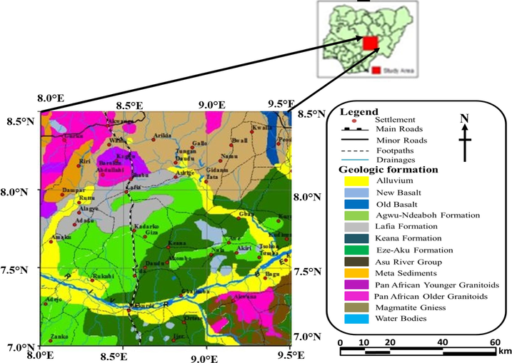
Geologic map of the study area.
The MBT is part of the Nigerian Benue Trough that connects the Gulf of Guinea in the South to the Chad Basin in the North. It is believed to be associated with the opening of the Atlantic Ocean that ended in the early Tertiary with the creation of the Tertiary Niger Delta (Obaje, 2009). The Benue Trough is characterized by extensive magmatic and tectonic activities as evidenced by the widespread occurrence of intrusive and extrusive rocks (Ofoegbu, 1985).
The Asu River Group (ARG) of Mid-Albian to Late-Albian, composed of shale, limestone with sandstone intercalation (Offodile, 1976) sits unconformably on the crystalline basement rocks (Offodile, 1976; Offodile and Reyment, 1978). At various locations, the Keana Formation (made up of poorly sorted feldspathic coarse-grained sandstone that sometimes contains pebbly conglomerate) and the Awe Formation (consisting of flaggy whitish coarse-medium grained sandstone interbedded with carbonaceous shale, clay, and sandy limestone), both overlies the ARG. The Ezeaku and Awgu Formations (Offodile and Reyment, 1978) comprise black shale, sandstone, coal, and limestone. The reportedly youngest Lafia Formation is dominated by coarse-grained sandstone, loose sands, mudstone, and clay (Offodile, 1976; Offodile and Reyment, 1978).
3 Materials and method
3.1 Data acquisition
The dataset was acquired using a Flux-Adjusting Surface Data Assimilation System with 0.1 km of flight-line space, 0.5 km of tie-line space, and terrain clearance ranging from 0.08 to 0.1 km, by Fugro Airborne Surveys, Canada. The data used in this study were processed into total magnetic intensity gridded data, which were then displayed as images in colour raster format (Fig. 2). Since the data were collected at low latitudes, the magnetic data were reduced to the equator (RTE). Jain (1988) reported that RTE generates more reliable results, especially at middle and lower latitudes.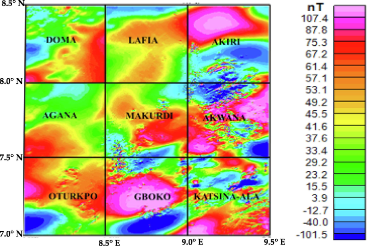
(a) Total magnetic intensity map of the study area.
3.2 Spectral analysis of magnetic anomalies involving centroid depth method
Spectral analysis using the centroid method is a potent tool used in the determination of Curie point depth (Tanaka, 2017; Tanaka et al., 1999). It is often applied using the azimuthally averaged power spectrum of magnetic anomalies (Tanaka, 2017). The power spectra of the magnetic anomaly are expressed as:
Assuming that the magnetization and geomagnetic field directions are constant, Eq. (1) can be rewritten as (Tanaka et al. 1999):
Using random magnetisation models, and if magnetisation M(x,y) is completely random,
will be constant (Tanaka et al., 1999). As a result, Eq. (3) becomes:
The low-wavenumber portion of the power spectrum can be approximated to estimate the centroid depth (Zc) of the magnetic layer (Tanaka et al., 1999):
Assuming the distribution of the magnetization in the crust is random and uncorrelated, the azimuthally averaged power spectrum can be used to calculate Zt and Zb by Eqs. (5)–(7).
3.3 Conductive heat flow
Fourier's law is a fundamental relationship when considering conductive heat conveyance (Tanaka et al. 1999). Fourier's law takes the following form in the one-dimensional case, assuming a vertical direction for temperature variation and a constant temperature gradient dT/dz:
The Curie temperature (θ) can be defined as:
3.4 Results
The magnetic method is a powerful procedure in the assessment of the lateral extent of several high-temperature geothermal sources (Ben et al., 2022a, 2022b), paleo-permeability structures (Ejiga et al., 2022), and the magnitude of hydrothermally altered rocks. To map both small and large geothermal anomalies, the magnetic data (Fig. 2) used in this study were partitioned into 216 spectral blocks with 50% overlap of each block before the creation of power spectrum plot for each block. Associated parameters like CPD or Zb, GG and HF were obtained, which were afterwards gridded in 2- and 3-D formats.
The CPD values (Fig. 3) were observed to vary from 6 to 8 km (shallow), 8–12 km (medium), and 12–16 km (deep) from magnetic data analysis. Fig. 3 indicates shallow CPD (red colour) within Gboko and Otukpo areas. Research showed that Gboko and Otukpo regions that fall within the GA dominated by granite (2.64 gcm−3) and gabbro (2.90 gcm−3) are the contributing effects of Abakaliki Anticlinorium (Abdullahi and Kumar, 2020). The remaining area which is dominated by medium-deep CPD is characterised by some sparely distributed shallow CPD. The GG maps (Fig. 4) for magnetic data are characterised as low (38–62 °C/km), medium (62–74 °C/km) and high (74–94 °C/km), respectively. Additionally, the magnetic (155–235 mW/m2) result indicates that the Otukpo and Gboko regions are dominated by high HF. Other areas like Agana, Doma, Lafia, Akiri, and Akwana are characterized by low HF values (95–125 mW/m2). The correlated high GG (Fig. 4) and HF (Fig. 5) locations coincide with the positions (Gboko and Otukpo) of shallow CPD in Fig. 3. In general, it has been observed by Ejiga et al. (2022) and Abraham et al. (2019) that CPD and other related parameters are reliant on tectonic events.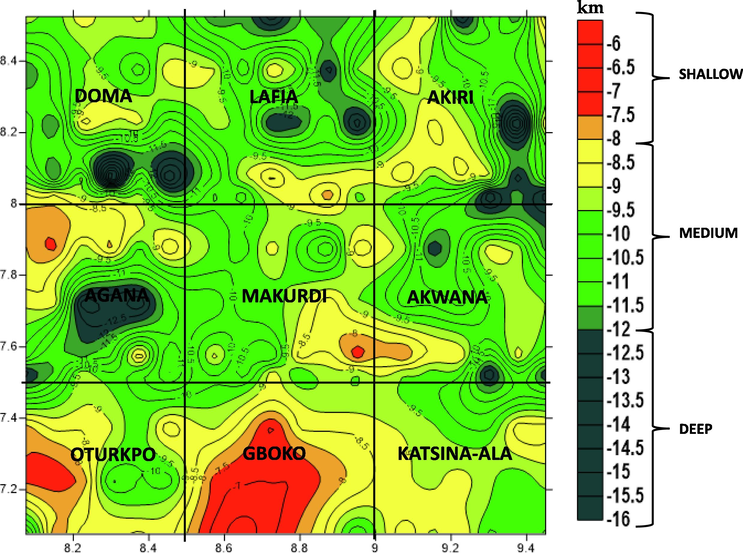
Curie point depth map of the study area.
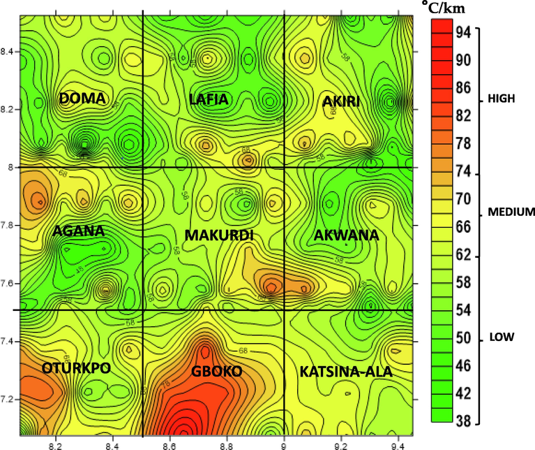
Geothermal gradient map of the study area.
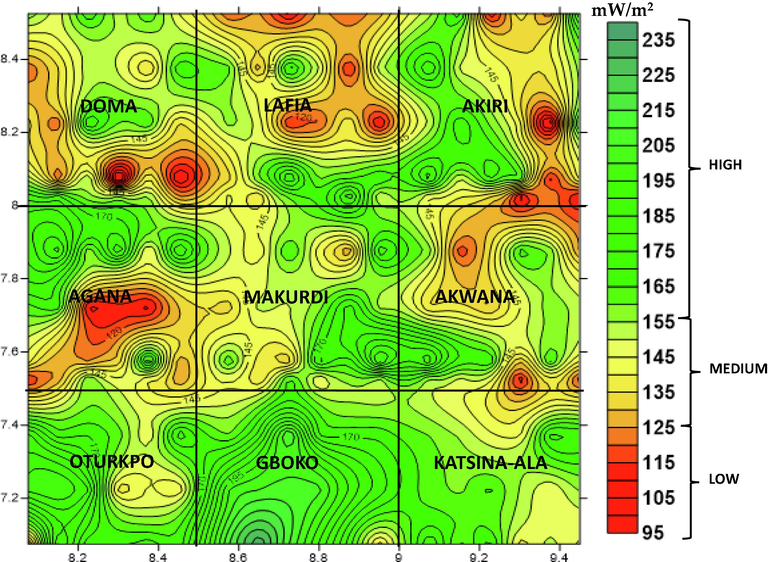
Heat flow map of the study area.
4 Discussion
Magnetic technique is the main operational geophysical tool that can efficiently map geothermal reservoirs, and interconnected geothermal systems (Represas et al., 2013). The range of CPD (6.0–16.0 km) obtained in this study differs fairly with Curie depth of 11 ± 2–18 ± 4 km and 9–20 km obtained by Abdullahi and Kumar (2020), and Abraham et al. (2019) findings, respectively. The GG range (38–94 °C/km) from the magnetic data are higher than the range of values (29.0–45.8 °C/km) previously obtained in the AA (Abraham et al., 2019; Onuoha and Ekine, 1999). The shallow CPD (6.0–8.0 km) (Figs. 3 and 6) witnessed within Gboko and Otukpo indicates the signature of Santonian intrusions related to the AA (Abdullahi and Kumar, 2020; Abraham et al., 2019) that straddled into the MBT. The remaining parts within the study area are defined by medium-deep CPD (8.0–16.0 km) characterised by some pockets of relatively medium–low GG and HF (Figs. 4 and 5). However, results of Moho depths from regional seismological and gravity investigations reported Moho depths of 10–20 km (Abdullahi et al. 2019; Fairhead et al. 1991). Likewise, the reported HF (Fig. 6) values (95–235 mW/m2) were significantly greater than previous results (Abraham et al., 2019; Onuoha and Ekine, 1999). Generally, previous researches have shown that regions with anomalous HF values >80 mW/m2 indicate geothermal anomaly (Abraham et al., 2015; Sharma, 2004). The delineated structures (Figs. 4 and 5) within GA, which coincide shallow CPD (<8.0 km) matches with high GG (>74 °C/km) and HF (>155 mW/m2) region. These geothermal anomalies are associated to AA (Ekwok et al., 2022a, 2021a, 2021b, 2020b). The 3-D presentation of CPD, GG and HF (Fig. 6) revealed succinctly that the GA is characterised by high geothermal potentials. The shallow CPD zones (<8 km) defined by spikes (Fig. 6(a)) correlate with the positions of high GG (Fig. 6(b)) and HF and (Fig. 6(c)). Bansal et al. (2011) observed that probable geothermal regions are defined by shallow CPD, and high GG and HF. These main geothermal anomalies (in Gboko and Otukpo) plus the scantily distributed geothermal anomalies (Ofoegbu, 1985) in the remaining parts of the study area, are thought to be the main source of brines (Ekwok et al., 2022b, 2021c, 2021a, 2019) and lead–zinc mineralisation (Ekwok et al., 2022a; Akpan et al., 2014).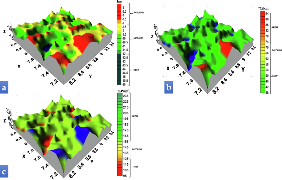
(a) 3-D Curie point depth, (b) geothermal gradient, and (c) heat flow models of the study area.
5 Conclusions
In this research, CPD, GG and HF estimates of the Middle Benue Trough of Nigeria were presented. The Curie depths computed from this study vary from 6.0 to 16.0 km. The locations of shallow CPD (6.0–8.0 km) coincide with GA related to expansive Santonian intrusions of AA. The delineated geothermal zones within the GA indicate shallow CPD (<8.0 km), and high GG (>74 °C/km) and HF (>155 mW/m2) values. Other areas within the study area characterised by medium-deep CPD (8.0–16.0 km), are dominated by medium–low GG (<74 °C/km) and HF (<155 mW/m2) values. It can be concluded that this research involving magnetic data serves as reconnaissance investigation for geothermal energy resources in the MBT. Notwithstanding the successful delineation of geothermal anomalies within GA, further study involving the integration of deep boreholes, seismic, magneto-telluric, electromagnetic and geochemical data, should be carried out to further evaluate and sufficiently model the geothermal reservoir of GA and adjoining AA.
Acknowledgments
This research was supported by Researchers Supporting Project number (RSP2023R432), King Saud University, Riyadh, Saudi Arabia.
Declaration of Competing Interest
The authors declare that they have no known competing financial interests or personal relationships that could have appeared to influence the work reported in this paper.
References
- Curie depth estimated from high-resolution aeromagnetic data of parts of lower and middle Benue trough (Nigeria) Acta Geod. Geophys.. 2020;55(4):627-643.
- [Google Scholar]
- Crustal structure of southern Benue Trough, Nigeria from 3D inversion of gravity data. J. Geol. Min. Res.. 2019;11(4):39-47.
- [Google Scholar]
- Geothermal energy reconnaissance of Southeastern Nigeria from analysis of aeromagnetic and gravity data. Pure Appl. Geophys.. 2019;176:1615-1638.
- [Google Scholar]
- Review of geothermal energy research in Nigeria: The geoscience front. Int. J. Earth Sci. Geophys.. 2017;3
- [Google Scholar]
- Estimating depth to the bottom of magnetic sources at Wikki Warm Spring region, northeastern Nigeria, using fractal distribution of sources approach. Turk. J. Earth Sci.. 2015;24(5):494-512.
- [Google Scholar]
- A gravity interpretation of the Benue Trough, Nigeria. Tectonophysics. 1981;79:109-128.
- [Google Scholar]
- Tectonic and sedimentation framework of the lower Benue Trough, Southeastern Nigeria. J. Afr. Earth Sci.. 1983;3(4):267-274.
- [Google Scholar]
- Geophysical and laboratory studies of the spread and quality of the Odukpani limestone deposit. Am. J. Environ. Sci.. 2004;10(4):347-356.
- [Google Scholar]
- Geophysical and Geological Studies of the Spread and Industrial Quality of Okurike Barite Deposit. Am. J. Environ. Sci.. 2014;10(6):566-574.
- [Google Scholar]
- Seasonal reversals in groundwater flow direction and its role in the recurrent Agwagune landslide problem: a geophysical and geological appraisal. Environ. Earth Sci.. 2016;75:429.
- [CrossRef] [Google Scholar]
- Low-enthalpy geothermal springs for power generation – an alternative approach. Open Access Libr. J.. 2019;6:1-13. e5866
- [CrossRef] [Google Scholar]
- Estimation of the depth to the bottom of magnetic sources by a modified centroid method for fractal distribution of sources: an application to aeromagnetic data in Germany. Geophysics. 2011;76:L11-L22.
- [Google Scholar]
- A novel method for estimating model parameters from geophysical anomalies of structural faults using the manta-ray foraging optimization. Front. Earth Sci.. 2022;10:870299
- [CrossRef] [Google Scholar]
- Interpretation of magnetic anomalies by simple geometrical structures using the manta-ray foraging optimization. Front. Earth Sci.. 2022;10:849079
- [CrossRef] [Google Scholar]
- Polymetallic Mineralization prospectivity modelling using multi-geospatial data in Logistic regression: the Diapiric Zone, Northeastern Algeria. Geocarto Int. 2022
- [CrossRef] [Google Scholar]
- Geothermal energy assessment through the Curie point depth, geothermal gradient, and heat flow around the Akiri hot spring region in Central Nigeria. Environ. Earth Sci.. 2022;81:115.
- [CrossRef] [Google Scholar]
- Enhancement and modelling of aeromagnetic data of some inland basins, southeastern Nigeria. J. Afr. Earth Sc.. 2019;155:43-53.
- [Google Scholar]
- Assessment of groundwater potential using geophysical data: a case study in parts of Cross River State, south-eastern Nigeria. Appl. Water Sci.. 2020;10:144.
- [CrossRef] [Google Scholar]
- Exploratory mapping of structures controlling mineralization in Southeast Nigeria using high resolution airborne magnetic data. J. Afr. Earth Sci.. 2020;162:103700
- [Google Scholar]
- Assessment of crustal structures by gravity and magnetic methods in the Calabar Flank and adjoining areas of Southeastern Nigeria-a case study. Arab. J. Geosci.. 2021;14(4):1-10.
- [Google Scholar]
- Assessment of depth to magnetic sources using high resolution aeromagnetic data of some parts of the Lower Benue Trough and adjoining areas, Southeast Nigeria. Adv. Space Res.. 2021;67(7):2104-2119.
- [Google Scholar]
- Depth Estimation of Sedimentary Sections and Basement Rocks in the Bornu Basin, Northeast Nigeria Using High-Resolution Airborne Magnetic Data. Minerals. 2022;12:285.
- [CrossRef] [Google Scholar]
- Towards understanding the source of brine mineralization in Southeast Nigeria: Evidence from high-resolution airborne magnetic and gravity data. Minerals. 2022;12:146.
- [CrossRef] [Google Scholar]
- Implications of tectonic anomalies from potential field data in some parts of Southeast Nigeria. Environ. Earth Sci.. 2022;81:6.
- [CrossRef] [Google Scholar]
- Application of the enhanced horizontal gradient amplitude (EHGA) filter in mapping of geological structures involving magnetic data in Southeast Nigeria. J. King Saud Univ.-Sci.. 2022;34:102288
- [Google Scholar]
- Application of High-Precision Filters on Airborne Magnetic Data: A Case Study of the Ogoja Region, Southeast Nigeria. Minerals. 2022;12:1227.
- [CrossRef] [Google Scholar]
- Structural and lithological interpretation of aero-geophysical data in parts of the Lower Benue Trough and Obudu Plateau, Southeast Nigeria. Adv. Pace Res. 2021
- [CrossRef] [Google Scholar]
- Structural interpretation of potential field data using the enhancement techniques: a case study. Geocarto Int. 2022
- [CrossRef] [Google Scholar]
- Structural analysis and basement topography of Gabal Shilman area, South Eastern Desert of Egypt, using aeromagnetic data. J. King Saud Univ. – Sci.. 2022;34(2):101764. ISSN 1018-3647
- [CrossRef] [Google Scholar]
- Eldosouky, A.M., Pham, L.T., El-Qassas, R.A.Y., Hamimi, Z., Oksum, E., 2021. Lithospheric Structure of the Arabian–Nubian Shield Using Satellite Potential Field Data. In: Hamimi Z., Fowler AR., Liégeois JP., Collins A., Abdelsalam M.G., Abd EI-Wahed M. (Eds.), The Geology of the Arabian-Nubian Shield. Regional Geology Reviews. Springer, Cham. https://doi.org/10.1007/978-3-030-72995-0_6.
- High precision structural mapping using edge filters of potential field and remote sensing data: A case study from Wadi Umm Ghalqa area, South Eastern Desert, Egypt. Egypt. J. Remote Sens. Space Sci.. 2022;25(2):501-513.
- [CrossRef] [Google Scholar]
- Detection of porphyry intrusions using analytic signal (AS), Euler Deconvolution, and Center for Exploration Targeting (CET) Technique Porphyry Analysis at Wadi Allaqi Area, South Eastern Desert, Egypt. Int. J. Sci. Eng. Res.. 2016;7(6):471-477. ISSN 2229-5518
- [Google Scholar]
- Probability of mineral occurrence in the Southeast of Aswan area, Egypt, from the analysis of aeromagnetic data. Arab. J. Geosci.. 2021;14:1514.
- [CrossRef] [Google Scholar]
- Sedimentary cover determination and structural architecture from gravity data: East of Suez Area, Sinai, Egypt. Arab J Geosci. 2022;15:109.
- [CrossRef] [Google Scholar]
- Crustal structure of the Mamfe basin, West Africa based on gravity data. Tectonophysics. 1991;186:351-358.
- [Google Scholar]
- Comparative study of estimating the Curie point depth and heat flow using potential magnetic data. Open Geosci.. 2022;2022(14):462-480.
- [Google Scholar]
- Total magnetic field reduction-The Pole or Equator? A model study. Can. J. Explor. Geophys.. 1988;24(2):185-192.
- [Google Scholar]
- Mackay, R.A., 1946. A comparative study of two lead-zinc occurrences in Plateau and Ogoja Provinces Ann. Report, GeoL Surv. Nigeria.
- Integration of remote sensing and geophysical data for the extraction of hydrothermal alteration zones and lineaments; Gabal Shilman basement area, Southeastern Desert, Egypt. J. Afr. Earth Sci.. 2022;194:104640. ISSN 1464-343X
- [CrossRef] [Google Scholar]
- Mariita, N.O., 2010. Application of geophysical methods to geothermal energy exploration in Kenya. Presented at Short Course V on Exploration for Geothermal Resources, organized by UNU-GTP, GDC and KenGen, at Lake Bogoria and Lake Naivasha, Kenya, Oct. 29-Nov. 19, 2010.
- Crustal architecture, heat transfer modes and geothermal energy potentials of the Algerian Triassic provinces. Geothermics. 2021;96:102211. ISSN 0375-6505
- [CrossRef] [Google Scholar]
- Integrated magnetic and gravity surveys for geothermal exploration in Central Iran. Arab. J. Geosci.. 2016;9:506.
- [Google Scholar]
- Approximate geothermal gradients in Niger Delta Sedimentary Basin. AAPG Bull.. 1976;60(7):1073-1077.
- [Google Scholar]
- Geology and Mineral Resources of Nigeria. Heidelberg, Germany: Springer; 2009.
- Analysis of magnetic data over the Abakaliki Anticlinorium of the Lower Benue Trough, Nigeria. Mar. Pet. Geol.. 1991;8:174-183.
- [Google Scholar]
- A review of the geology of the Benue trough, Nigeria. J. Afr. Earth Sci.. 1985;3(3):283-291.
- [CrossRef] [Google Scholar]
- Offodile, M.E., 1976. The Geology of the Middle Benue, Nigeria, vol. 4. Paleontological Institute, University Uppsala, Special Publication, pp. 1–166.
- Offodile, M.E., Reyment, R.A., 1978. Stratigraphy of the Keana-awe area of the middle Benue region of Nigeria. Bull. Geol. Inst. Univ. Uppsala 7, 37–66.
- Subsurface temperature variation and heat flow in the Anambra Basin, Nigeria. J. Afr. Earth Sci.. 1999;28(3):641-652.
- [Google Scholar]
- Determination of maximum tilt angle from analytic signal amplitude of magnetic data by the curvature-based method. Vietnam J. Earth Sci.. 2018;40(4):354-366.
- [Google Scholar]
- Estimation of Curie point depths in the Southern Vietnam continental shelf using magnetic data. Vietnam J. Earth Sci.. 2019;41(3):216-228.
- [Google Scholar]
- Subsurface structural mapping from high-resolution gravity data using advanced processing methods. J. King Saud Univ. – Sci.. 2021;33(5):101488. ISSN 1018-3647
- [CrossRef] [Google Scholar]
- An improved approach for detecting the locations of the maxima in interpreting potential field data. Arab. J. Geosci.. 2021;14:43.
- [CrossRef] [Google Scholar]
- Determination of subsurface lineaments in the Hoang Sa islands using enhanced methods of gravity total horizontal gradient. Vietnam J. Earth Sci.. 2022;44(3):395-409.
- [Google Scholar]
- Interpretation of gravity data to delineate structural features connected to low temperature geothermal resources at Northeastern Portugal. J. Appl. Geophys.. 2013;92:30-38.
- [Google Scholar]
- Understanding the structural framework controlling the sedimentary basins from the integration of gravity and magnetic data: A case study from the east of the Qattara Depression area, Egypt. J. King Saud Univ. – Sci.. 2022;34(2):101808. ISSN 1018-3647
- [CrossRef] [Google Scholar]
- Insights on the tectonic styles of the Red Sea rift using gravity and magnetic data. Mar. Petrol. Geol. 2021:105253. ISSN 0264-8172
- [CrossRef] [Google Scholar]
- New insights into the contribution of gravity data for mapping the lithospheric architecture. J. King Saud Univ. – Sci. 2021:101400. ISSN 1018-3647
- [CrossRef] [Google Scholar]
- Environmental and engineering geophysics. Cambridge: Cambridge University Press; 2004. p. :475.
- Simpson, A., 1955. The Nigerian coalfield: the geology of parts of Owerri and Benue Provinces Bull. Geol, Surv. Nigeria, No. 24.
- Global centroid distribution of magnetized layer from world digital magnetic anomaly map. Tectonics. 2017;36:3248-3253.
- [CrossRef] [Google Scholar]
- Curie point depth based on spectrum analysis of the magnetic anomaly data in East and Southeast Asia. Tectonophysics. 1999;306(3):461-470.
- [CrossRef] [Google Scholar]
- Evolution of saline waters and brines in the Benue-Trough, Nigeria. Appl. Geochem.. 2004;19:1355-1365.
- [Google Scholar]
Appendix A
Supplementary data
Supplementary data to this article can be found online at https://doi.org/10.1016/j.jksus.2022.102521.
Appendix A
Supplementary data
The following are the Supplementary data to this article:


