

Translate this page into:
Evaluation of hydrocarbon source rock potential: Deep marine shales of Belaga Formation of Late Cretaceous-Late Eocene, Sarawak, Malaysia
⁎Corresponding authors at: Department of Geosciences, Universiti Teknologi PETRONAS, Seri Iskandar, Perak, 32610, Malaysia (Numair A. Siddiqui). nisarpu12@gmail.com (Nisar Ahmed), numair.siddiqui@utp.edu.my (Numair A. Siddiqui)
-
Received: ,
Accepted: ,
This article was originally published by Elsevier and was migrated to Scientific Scholar after the change of Publisher.
Peer review under responsibility of King Saud University.
Abstract
In the Sibu-Tatau region of Sarawak, the Belaga Formation (Late Cretaceous- Late Eocene turbidites) is interpreted in relation to a submarine fan model deposited in the extinct ocean basin of the proto-South China Sea. A number of clastic rocks, which include sandstone, siltstone, mudstone, and black shale, define the formation. While it is considered one of the Rajang group's extensive and well-studied formations, yet no comprehensive studies have been carried out on the shales in Sarawak, Malaysia, to interpret their importance as a source rock to oil and gas fields. The present study highlights the prominent lithofacies in addition to the detailed source rock characterization of each member of Belaga Formation to discuss the potential source rock intervals present in these Cretaceous to Eocene rock units. Four major types of shales and mudstones facies were observed in the field, i.e. (i) Variegated colored shale facies (VSF), (ii) Black “Papery” shale facies (BSF), (iii) Gray to black mudstone facies (GMF), (iv) Silty/sandy shale facies (SSF). They show hemipelagic settling in a calm environment to turbiditic deposition at levees as well as distal lobe depositional environment. In this study primary geochemical studies such as Rock-Eval pyrolysis and Total Organic Carbon (TOC) analysis were used to classify the thermal maturity, organic matter richness, and kerogen type of the studied shales. Forty-six selected shale samples were studied from the formation, including samples from members of the Layar (Upper Cretaceous), Kapit (Paleocene to Early Eocene), Pelagus (Early to Middle Eocene), Metah (Middle to Late Eocene) and Bawang (Eocene). The shales of Belaga Formation typically display low to moderate source rock potential, which is obvious by low TOC contents between 0.14 wt% and 7.22 wt% (average of about 2.97 wt%) and show a wide range of maturity (immature to over mature) evident from very low to very high Tmax values ranging from 293 °C to 610 °C. The results show that the kerogen is of type IV, with some units can be potential sources of gas.
Keywords
Turbiditic black shales
Belaga Formation
Source rock evaluation
Organic matter
Rock-Eval pyrolysis
NW Borneo

1 Introduction
To study the hydrocarbon generation, source rock evaluation is important in terms of organic matter with quality, and richness that is influenced by the composition and concentration of organic matters. The organic matter in the source rocks is usually investigated through various laboratory techniques of geochemical and petrological nature (Liu et al. 2019). Among these Rock-Eval pyrolysis is being extensively used worldwide, as a basic tool for the exploration of oil and gas in sedimentary basins. TOC of the source rocks is a direct indication of organic richness, whereas indices of hydrogen and oxygen known as HO and OI, are usually used for the determination of kerogen types. Thermal or heat maturity of the source rocks is easy to measure from Rock-Eval pyrolysis, which is based on the heat parameters with reference to the maximum temperature, Tmax.
In Sarawak Basin, NW Borneo, the Tertiary sediments (humic coals) are main hydrocarbon producing intervals and these are also serving as the source rocks for oil and gas for younger sequences. These Tertiary rocks are also overlying the thick deep marine turbidite Belaga Formation. Many researchers have studied the Belaga Formation (Ahmed et al., 2019, 2020; Galin et al., 2017; Kuswandaru et al., 2019; Maisie et al., 2019; Murtaza et al., 2015), to mark the sedimentary and stratigraphic architecture but with less interest in the source rock evaluation by geochemical and petrological analyses. One of the major reasons for this is the previously reported possible effect of metamorphism due to folding and faulting on this rock unit, which in turn was based on only limited exposures. The recent infrastructure development of Pan Borneo Highway, Sarawak Section, enabled us to mark unmetamorphosed zones and facilitated to pinpoint the promising fresh exposures of sedimentary greyish-black shales. In this research, Belaga Formation shales are assessed for the ability to generate hydrocarbons to evaluate their source rock potential. In order to determine the hydrocarbon generation potential, three main properties are geochemically assessed; (1) type of organic matter, (2) organic carbon content and (3) organic maturity level by applying Rock-Eval pyrolysis and total organic carbon (TOC) content.
2 Geology of study area
Borneo Island is a complex region with respect to geology and tectonics. The Sarawak region consists of three main geological zones within the regional tectonic system, namely the Miri Zone, the Sibu Zone and the Kuching Zone (Ahmed et al., 2019, 2020; Mat-Zin and Tucker, 1999; Ramkumar, 2018; Siddiqui, 2020) (Fig. 1). Belaga Formation is the Rajang Fold-Thrust Belt’s or Rajang Group's most widespread and better-known formation, especially in Sibu Zone and partially in Miri zone of Central Sarawak (covers up to 95% of Rajang). These thick (more than 4.5 km) deep marine turbidite sediments of Late Cretaceous to Late Eocene were deposited at an interval of about 30 Ma and denote a major submarine fan and, to some extent, an accretionary prism and is amongst the one of the largest ancient submarine fans in the world (Galin et al., 2017; Hutchison, 2005; Moss, 1998). Previously, it was divided into five members based on paleontological distinctions along with little sedimentological differences. Members of Belaga Formation are arranged in the order from oldest to youngest, as follows: (1) Layar Member, (2) Kapit Member, (3) Pelagus Member, (4) Metah Member (of Sibu Zone) and (5) Bawang Member (Miri Zone’s lower part) (Liechti 1960) (Fig. 1).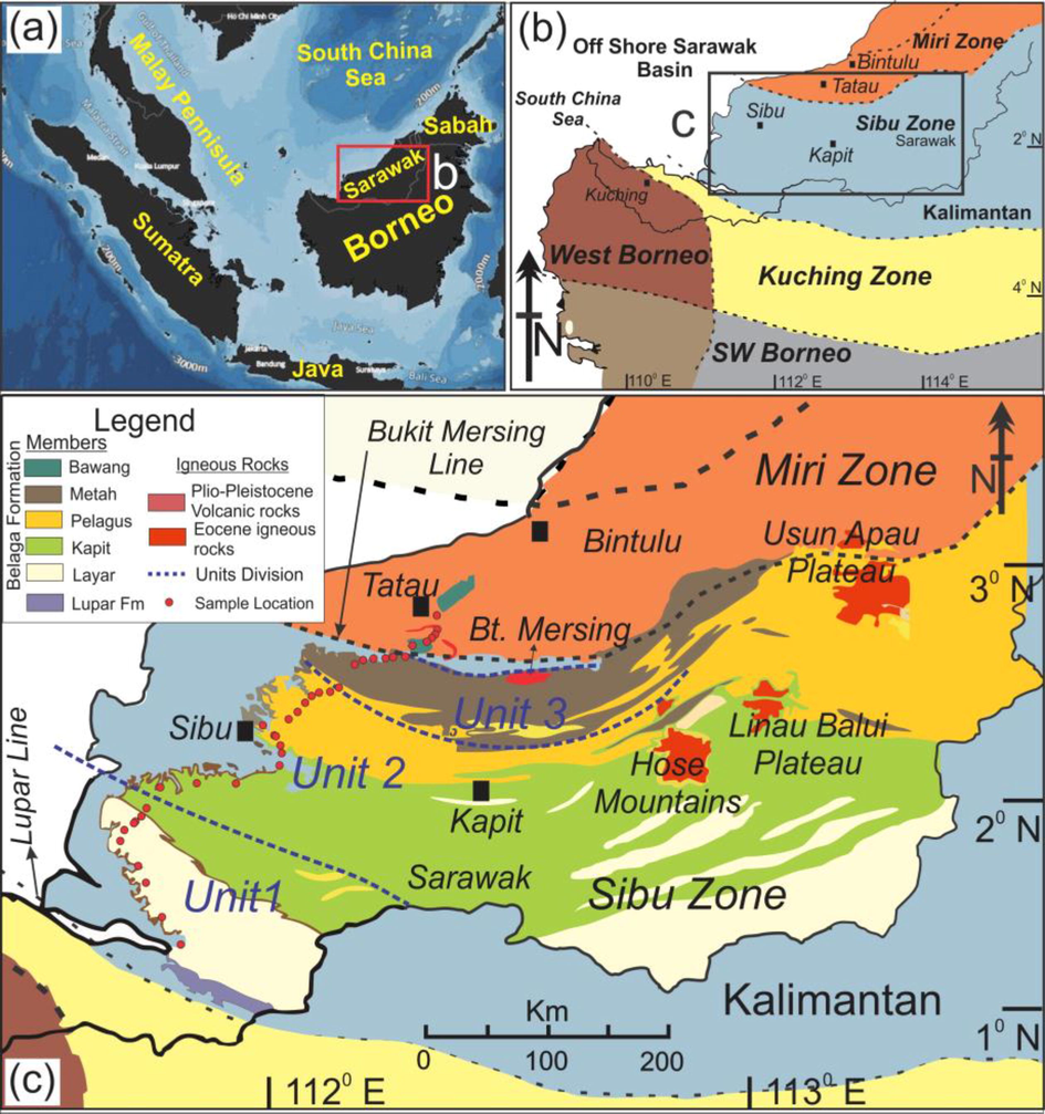
Geological and Tectonic map of the Central Sarawak, northwest Borneo, showing the location of: (a) Borneo island and surrounding regional geographical units in the Southeast Asia; (b) various tectonic zones i.e. Kuching Zone, Sibu Zone, Miri Zone and SW Borneo are from Haile (1974) and the West Borneo areas as by Hennig et al. (2017); (c) study area with sample locations (small red circles) as well as different divisions/units of the Belaga Formation modified from Liechti et al. (1960), Heng (1992), Galin et al. (2017) and Hennig-Breitfeld et al. (2019). Note, the younging trend for members or units of Belaga Formation is from SW to NE.
Galin et al. (2017) subdivided this formation into four units based on zircon geochronology and depositional provenances. They have placed the Lupar Formation, Layar Member and lower part of Kapit Member in Unit 1 (Late Cretaceous-Early Eocene); upper part of Kapit Member and Pelagus Member in Unit 2 (Early to Middle Eocene); and the previous fourth Metah Member in Unit 3 (Middle to early Late Eocene). Bawang Member, the fifth member, was named as Unit 4 and kept as undifferentiated. Recently Bawang Member was separated from the older component by Hennig-Breitfeld et al. (2019) and suggested a new “Unit 4 of Miri Zone” definition. They included late Middle Eocene (Bukit Piring, Arip Volcanics) igneous rocks, Arip Limestones (biostratigraphy-based late Middle Eocene age confirmed!), some portion of the previous Bawang Member revealed between Arip River and Bukit Mersing Line (i.e. the lower part of the Tatau Formation).
3 Materials and methods
It is not easy to get fresh and unweathered rock samples in geology, especially in the tropical regions e.g. Sarawak. Thanks to Pan Borneo road expansion and construction project that excavated new outcrops for us as much deep as up to >25 m at different localities. Sedimentary features were recorded, and samples were collected through coring during the field visit from various fresh cut outcrops along the Jalan Sri Aman–Sarikei, Jalan Sibu–Sarikei, and Jalan Sibu–Bintulu highway in central Sarawak from all five members of the Belaga Formation. Number of samples are limited keeping the selective nature of outcrops based on three main points; i- only fresh road cuts were selected, ii- unmetamorphosed units were the focus and iii- omitting the repeated sequences of same member. Additionally, the samples were collected using Shaw portable core drill machine, to eliminate any slight possibility of weathered samples.
A total of forty-six (46) fresh and representative black shale core samples were used for geochemical analyses. Fig. 2 outlines the general workflow followed in this research. The samples were cleaned, dried, and pulverized during the sample preparation stage to ensure homogeneity and fine consistency, and further packed for different analyses. In the CGG Geoconsulting laboratory in North Wales, UK, about 100 mg of a pulverized portion of the shale samples is analyzed using a Rock-Eval/TOC VI version. The result includes parameter S1, which relates to the hydrocarbons that produces without cracking from the shales. Measured as milligrams of residual hydrocarbons per gram of rock (mg HC/g rock), parameter S2 refers to the second programmed heating stage varying from 300 °C to 600C. TOC is measured by oxidizing the pyrolysis residue at 600 °C in the air in a second oven.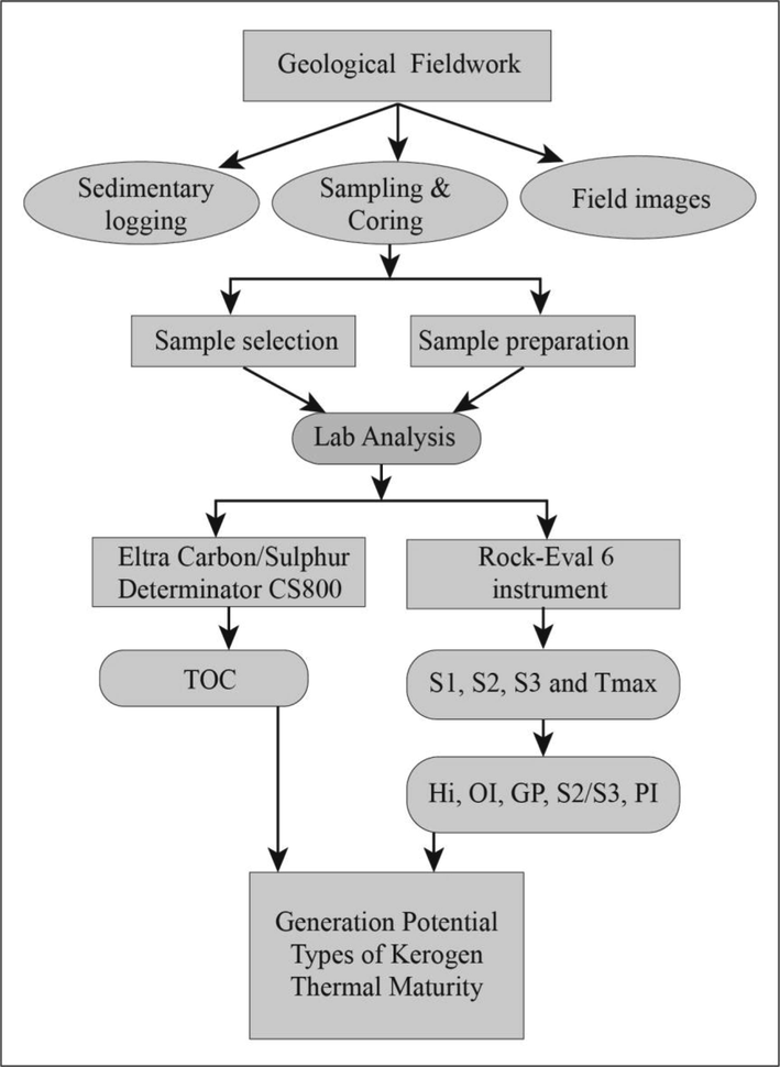
Summary of the general workflow followed in this research.
4 Results and discussion
4.1 Field observations- Mudstone/Shale facies
Mudstone facies is characterized by the accumulation and settling of finest particles in the form of dark grey to dark black colored laminas or tiny to massive mudstone/shale beds with thickness varying from few mm to10s of cm and up to 10 s of m. Based on the depositional process, mudstone facies can be divided into three distinctive subfacies, i.e. (i) Pelagic mudrock (ii) Hemipelagic mudstone facies (HMF) and (iii) turbidite mudstone facies (TMF). Pelagic and hemipelagic mudstone facies are primarily structureless and are deposited by continuous but slow background sedimentation. Whereas, turbidite mudstone facies are produced by a slowly diminishing turbulent flow and show a layered structure.
Most of the time, the facies (Te) associated with turbiditic graded sandstones can be simply interpreted as mudstones and is deposited by means of gradual floc settlement. Ripple sand/silt lenses reflect dilute turbidites and are interpreted as distal representations of Bouma's Tc division. The trace fossils of Nerites ichnofacies (Chondrites) are a fundamental constituent of various subtidal to deep marine environments. Following four major types of shales and mudstones facies were observed in the field.
4.1.1 Variegated colored shale facies (VSF)
This facies show various shades/weathering colors with the two prominent color variations, including, i)- Maroon red splintery shale, ii)- Light green (dull) splintery shale. Intercalation of thin silt and fine sand laminas alternating within these shales can also be found at places. Well-exposed sections of this facies have been observed in Bawang Member (Fig. 3a) as well as in the middle parts of Kapit Member. Fig. 3b is a general representative sedimentary log, which can be helpful in understanding the percentage of silty sand input in this facies. Based on sedimentary characteristics, these shales can be interpreted as turbidite mudstone facies (TMF), representing the more distal part of the deep marine lobe with a much calm depositional environment.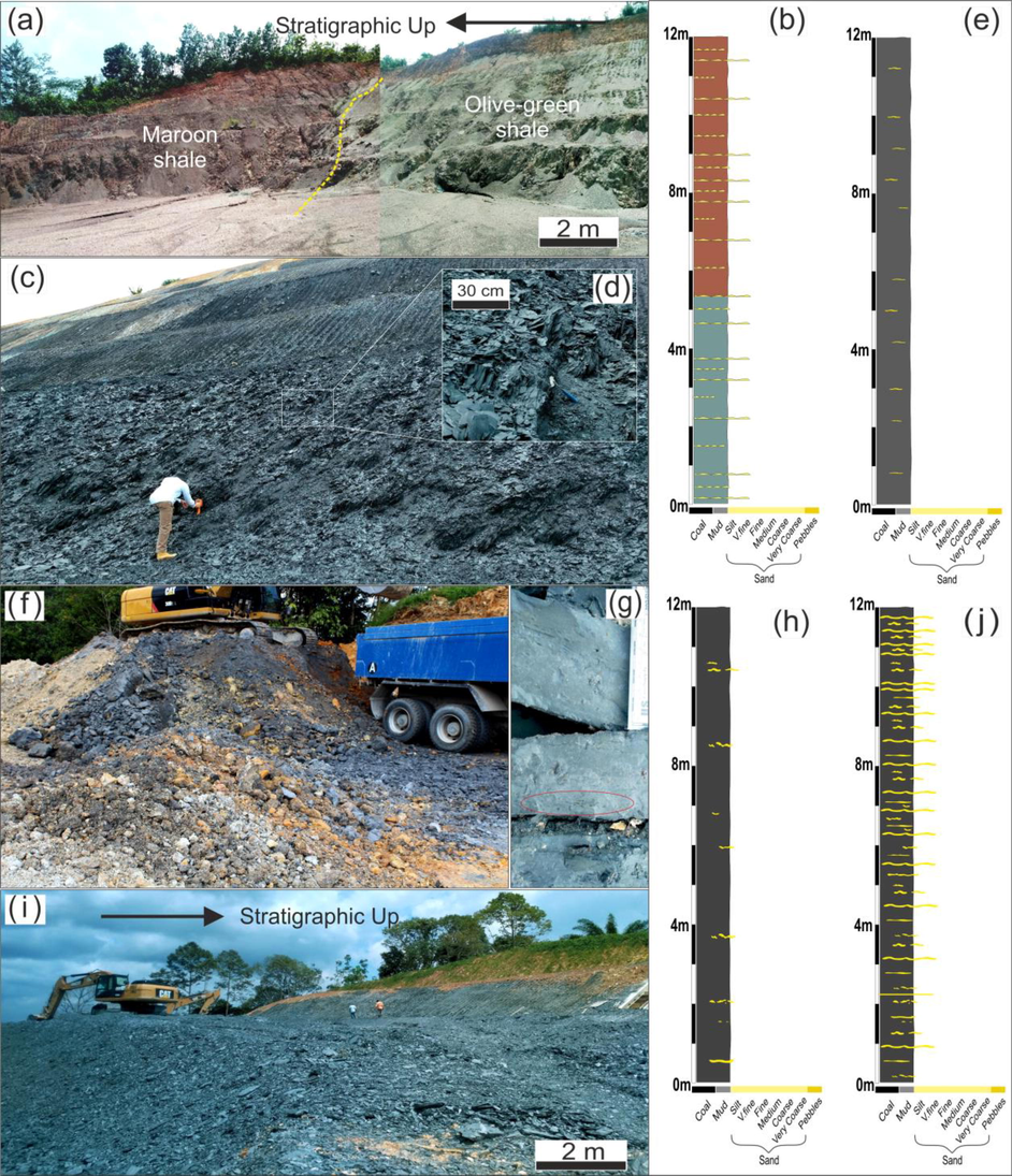
Sedimentary shale facies in different members of Belaga Formation. (a-b) Variegated color shale uppermost part of Bawang Member at Petronas pump section (Tatau), along with representative sedimentary log. (c-e) Black papery shale facies of Kapit Member observed only at Sebangkoi Country Resort, Sarikei, (d) inset is close up papery shales. (f-h) Black mudstone facies at Sekolah Kebangsaan Bukit Arip, Tatau, (g) close up of Chondrite ichnofacies. (i-j) Silty/sandy shale facies in Pelagus Member at 10 km SK Batau 36 Selangau. Note: Representative sedimentary logs of all facies are shown in b, e, h and j.
4.1.2 Black “Papery” shale facies (BSF)
This facies type has only been observed in Kapit Member, roughly 1 km away from Sebangkoi Country Resort, Sarikei, as shown in Fig. 3c. These shales are predominantly dark grey to dark black in color and are composed of thin parallel laminae which upon weathering break into sheets, resembling sheets of paper, hence named “Papery shale.” Some prominent features are highlighted in Fig. 3d-e. No to very little silt or fine-sand input (absence of prominent silt/sand lamina), coupled with non-fossiliferous nature and lack of trace fossils, confirm the interpretation of depositional environment as hemipelagic (HMF).
4.1.3 Gray to black mudstone facies (GMF)
Extensive outcrops of this facies are exposed in Bawang Member, Tatau region (Fig. 3f) as well as in Layar Member. This facies is composed of mudstones of dark gray to light black in color, massive in nature, and do not show any splintery behavior. When wrecked, it breaks in the form of massive blocks with well-defined and sharp bases. Layar Member’s section has chondrite ichnofacies (Fig. 3g). Sometimes this facies also occur in the Bouma turbidite sequence representing Te Bouma facies. Generally, no silt or sand lenses or laminae have been observed in the field (Fig. 3h). This facies can be interpreted as deposition from suspension or hemipelagic settling in a calm environment.
4.1.4 Silty/Sandy shale (SSF)
This facies is the most prominent and widespread of all the five members of Belaga Formation. Generally, such facies display a laminated structure: composed of alternating laminae to thin beds (Fig. 3i) of fine-grained rocks consisting of mudstone, claystone, siltstone, and fine-grained sandstones. Bright laminas (Bouma Tc) are mostly of fine-grained to medium-grained sandstone and siltstone (Fig. 3j), while dark laminae or beds are mainly mudstones (Td-Te). This facies is interpreted as a turbidite mudstone facies (TMF) and mostly develop in varying energy environment (low to high), typical of the levee as well as distal lobe setting.
4.2 Lab Analysis- organic geochemistry
The organic geochemical analysis results for the shales of all five Belaga Formation members are summarized in Table 1. The criteria used in this study to determine OM richness are TOC (total organic carbon content), S1 (pre-pyrolysis hydrocarbons/free hydrocarbons) and S2 (residual petroleum potential/remaining hydrocarbon generation potential), and genetic potential. Note: TOC: Total organic carbon in weight percent; S1: Free hydrocarbons percent in the rock (mg HC/g rock); S2: Residual petroleum potential (mg HC/g rock); HI: Hydrogen index (mg HC/g TOC); OI: Oxygen index (mg CO2/g TOC). Tmax: The temperature at which the maximum pyrolytic hydrocarbon (S2) liberated. PI: Production index = S1/S1 + S2. Generation potential (GP): S1 + S2. Hydrocarbons products type (QI): S2/S3. %R *: Calculated vitrinite reflectance
Sample
TOC (wt.%)
Tmax (°C)
S1 (mg/g)
S2 (mg/g)
S1 + S2
S2/S3
S3 (mg/g)
HI (mg/g)
OI (mg/g)
PI
%R *
Bawang Member
M5S1
0.33
329
0.03
0.05
0.08
0.28
0.18
15
55
0.38
−1.24
M5S2
0.31
516
0.01
0.05
0.06
0.63
0.08
16
26
0.17
2.13
M5S3
0.32
501
0.02
0.04
0.06
0.33
0.12
13
38
0.33
1.86
M5S4
0.47
501
0.02
0.04
0.06
0.44
0.09
9
19
0.33
1.86
M5S5
0.74
314
0.05
0.07
0.12
0.37
0.19
9
26
0.42
−1.51
M5S6
0.22
502
0.04
0.04
0.08
0.5
0.08
18
36
0.5
1.88
Metah Member
M4S1
0.71
610
0.02
0.06
0.08
0.22
0.27
8
38
0.25
3.82
M4S2
0.46
501
0.03
0.03
0.06
0.11
0.27
7
59
0.5
1.86
M4S3
0.3
502
0.01
0.04
0.05
0.44
0.09
13
30
0.2
1.88
M4S4
0.39
301
0.03
0.04
0.07
0.24
0.17
10
44
0.43
−1.74
M4S5
0.52
298
0.03
0.04
0.07
0.22
0.18
8
35
0.43
−1.80
M4S6
0.42
610
0.01
0.03
0.04
0.23
0.13
7
31
0.25
3.82
M4S7
0.51
597
0.02
0.06
0.08
0.67
0.09
12
18
0.25
3.59
Pelagus Member
M3S1
0.82
584
0.01
0.08
0.09
1
0.08
10
10
0.11
3.35
M3S2
0.61
605
0.03
0.07
0.1
0.44
0.16
11
26
0.3
3.73
M3S3
0.53
601
0.02
0.06
0.08
0.6
0.1
11
19
0.25
3.66
M3S4
0.64
605
0.02
0.08
0.1
0.38
0.21
13
33
0.2
3.73
M3S5
0.58
604
0.02
0.05
0.07
0.5
0.1
9
17
0.29
3.71
M3S6
0.63
605
0.02
0.05
0.07
0.42
0.12
8
19
0.29
3.73
M3S7
0.37
604
0.02
0.04
0.06
0.5
0.08
11
22
0.33
3.71
M3S8
0.4
584
0.02
0.06
0.08
0.67
0.09
15
23
0.25
3.35
M3S9
0.73
566
0.03
0.12
0.15
0.8
0.15
16
21
0.2
3.03
M3S10
7.22
586
0.03
0.89
0.92
4.24
0.21
12
3
0.03
3.39
M3S11
0.52
582
0.02
0.07
0.09
0.7
0.1
13
19
0.22
3.32
M3S12
0.4
598
0.01
0.03
0.04
0.5
0.06
8
15
0.25
3.60
M3S13
0.48
324
0.06
0.06
0.12
0.6
0.1
13
21
0.5
−1.33
M3S14
0.37
608
0.02
0.04
0.06
0.29
0.14
11
38
0.33
3.78
M3S15
0.32
604
0.02
0.05
0.07
0.33
0.15
16
47
0.29
3.71
M3S16
0.44
395
0.04
0.13
0.17
0.81
0.16
30
36
0.24
−0.05
M3S17
0.72
607
0.06
0.07
0.13
0.41
0.17
10
24
0.46
3.77
M3S18
0.42
597
0.01
0.05
0.06
0.31
0.16
12
38
0.17
3.59
Kapit Member
M2S1
0.14
328
0.02
0.03
0.05
0.27
0.11
21
79
0.4
−1.26
M2S2
0.17
501
0.02
0.03
0.05
0.43
0.07
18
41
0.4
1.86
M2S3
0.85
337
0.02
0.04
0.06
0.44
0.09
5
11
0.33
−1.09
M2S4
0.95
319
0.04
0.05
0.09
0.42
0.12
5
13
0.44
−1.42
M2S5
2.37
501
0.02
0.04
0.06
0.44
0.09
2
4
0.33
1.86
M2S6
0.67
350
0.02
0.04
0.06
0.33
0.12
6
18
0.33
−0.86
Layar Member
M1S1
0.87
300
0.03
0.05
0.08
1
0.05
6
6
0.38
−1.76
M1S2
0.75
342
0.02
0.05
0.07
0.45
0.11
7
15
0.29
−1.00
M1S3
1.01
326
0.04
0.08
0.12
0.3
0.27
8
27
0.33
−1.29
M1S4
0.86
293
0.03
0.04
0.07
0.25
0.16
5
19
0.43
−1.89
M1S5
0.29
502
0.01
0.04
0.05
0.5
0.08
14
28
0.2
1.88
M1S6
0.34
501
0.01
0.03
0.04
0.38
0.08
9
24
0.25
1.86
M1S7
0.59
501
0.02
0.03
0.05
0.43
0.07
5
12
0.4
1.86
M1S8
1.39
325
0.04
0.06
0.1
0.6
0.1
4
7
0.4
−1.31
M1S9
1.04
324
0.06
0.06
0.12
0.75
0.08
6
8
0.5
−1.33
4.2.1 Total organic matter content (TOC)
The overall shale’s TOC values for the five members of the Belaga Formation range from 0.14 to 7.22 wt%, with a 2.97 wt% average value, as shown in Table 1. Samples from some members show organic matter richness and may have low to moderate petroleum potential (wet to dry gas only, based on Tmax and S1, S2 values). The results also show that organic matter richness decreases from older Layar Member to younger Bawang Member. This might be due to the paleogeography and structural regime of the basin (Hennig-Breitfeld et al. 2019).
4.2.2 Genetic potential (Pyrolytic or potential Yield)
Potential Yield (PY) is derived in Rock-Eval pyrolysis from the summation of S1 and S2 values (under curves) and is also known as genetic potential (GP = S1 + S2). S1 (hydrocarbons formed prior to pyrolysis) is the volume of hydrocarbon already produced in the source rock by geospheric maturity and merely removed from the rock during pyrolysis. The overall S1 values of shales for all five members of Belaga Formation vary from 0.01 to 0.06 with overall average of 0.025 mg HC/g rock, which proposes a low generative capacity. Residual Petroleum Potential (S2), also known as hydrocarbon generative potential, is the bitumen that would be produced by continued burial and maturation until completion and decreases with the maturation. For Belaga Formation, overall S2 values range between 0.003 and 0.89 for the shale samples with an overall average of 0.07 mg HC/g rock (Table 2). They have low and poor generative ability (Peters and Cassa 1994).
Member
No. of Samples
TOC (wt %)
S1 + S2 (mg/g)
Overall Evaluation
Range
Average
Range
Average
Bawang
6
0.22–0.74
0.3983
0.06–0.12
0.077
Poor
Metah
7
0.3–0.71
0.4729
0.04–0.08
0.064
Poor to moderate
Pelagus
18
0.32–7.22
0.9
0.04–0.92
0.136
Poor to moderate
Kapit
6
0.14–2.37
0.8583
0.05–0.09
0.062
Poor to very good
Layar
9
0.29–1.39
0.7933
0.04–0.12
0.078
Poor to good
A good source rock will have a genetic potential (GP) of 2 kgHC/ton (2.204 mgHC/g) of rock. S1 + S2 levels for Belaga Formation shales range from 0.04 to 0.92 mg HC/g rock (Av. 0.097). The description based on the genetic potential of Tissot and Welte (2013) shows that there is no or very little hydrocarbon rock potential for Belaga shales. As seen in Fig. 4a, a cross plot of S1 + S2 versus TOC also shows that the shales are low in OM. Although most of the samples show very little source rock potential, few samples are in gas source region as shown in Fig. 4b (HI vs. TOC plot).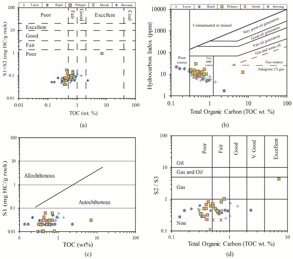
Discrimination plots, (a) of S1 + S2 versus TOC to show the genetic potential of the turbidite shales from Belaga Formation. (b) HI versus TOC plot for source rock characterization of studied samples. (c) a cross plot of S1 against TOC to discriminate indigenous and non-indigenous hydrocarbons; (d) S2/S3 against TOC values for the type of hydrocarbon product in studied samples.
Nevertheless, the plot of S1 vs TOC can be used to distinguish between allochthonous (non-indigenous) and autochthonous hydrocarbons (indigenous). Generally, the presence of migrated oil in shale rocks can be detected by the presence of high S1 values and high TOC values (Hunt 1995). This relation shows that the majority of the studied rock samples for the Layar, Kapit, Pelagus, Metah, and Bawang Members of Belaga Formation the source rocks were characterized by autochthonous hydrocarbons indicating that the oil was produced in the source rock itself, as shown in Fig. 4c.
The values of S2/S3 ratio for turbiditic shales of Belaga Formation range from 0.11 to 4.24. Predominant values are less than 1, that is why it can be overall classified as inert Type IV kerogen, except for 3 samples (i.e., M1S1, M3S10, and M13S1) consisting the ratio equal to or greater than 1. Fig. 4d is a cross plot of the representative shales' S2/S3 ratio against TOC and is also an indicator of generative
4.2.3 Genetic type of kerogen
The genetic type of kerogen is dependent on its origin and corresponding maceral composition. There is no universally accepted standard for classifying kerogen types. However, the classification of kerogen by pseudo-van Krevelen diagram (Fig. 5a), which is well-defined by elemental analysis and evolution paths, is helpful to decipher the type of hydrocarbon product (Borrok et al., 2019; Hafiz et al., 2020; Peters and Cassa, 1994; Tissot and Welte, 1980; Welte et al., 2012). Black shales of the Belaga Formation show low HI values <50 mg/g which are considered as inert type IV kerogen (Waples 2013), and are recycled and reworked residue. For kerogen classification, discrimination diagrams were prepared by using Hydrogen Index (HI) versus Tmax and also HI versus calculated vitrinite reflectance, as was carried out by Espitalie et al. (1986) and Chiadikobi and Chiaghanam (2018). These plots can be used to ascertain the type and maturity of kerogen. The plot of HI versus Tmax (Fig. 5a) shows that the majority of analyzed samples from older Layar Member and Kapit Member (∼66%) are immature along with few samples also coming in and around wet zone to dry gas zone of type IV kerogen, same results are found by HI vs OI plot (Fig. 5b). Prior to deposition, residual organic matter alteration happens by weathering, burning, or biological oxidation. Sediments from older reworked rocks have been eroded in some situations. Information from Precambrian zircons suggests that the sediments may have undergone substantial recycling due to several cycles of reworking of sediment through various processes, as assessed by mineralogical evaluation using zircons for the provenance analysis of the Belaga clastics (Galin et al. 2017).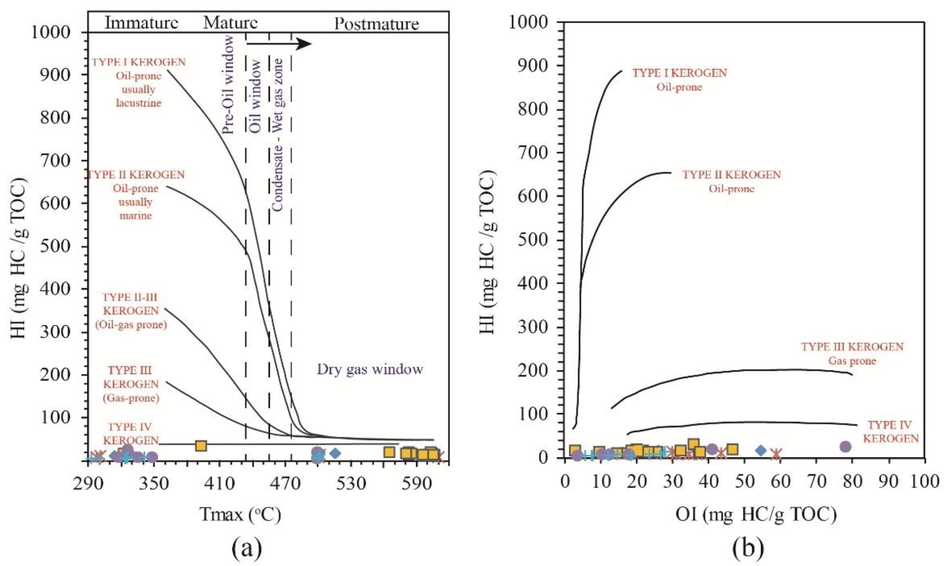
(a) The cross plot of HI vs Tmax showing the stages of thermal maturity and kerogen quality. (b) Classification of kerogen of HI against OI for studied samples of turbidite shales from Belaga Formation from central Sarawak.
4.2.4 Level of thermal maturation
Both the form of organic matter and thermal maturation determine the distribution and concentration of hydrocarbons emitted from a source rock. The geochemical parameters as Rock-Eval temperature “Tmax” and production index “PI” have been used to determine the thermal maturity of the source rocks, in the present study. In the present study, the overall Tmax (°C) values of the samples, from various members of Belaga Formation, range from 293 and 610 °C, along with different PI values (Fig. 6a). Samples from turbiditic shales fall under two extreme categories of either dry gas zone or inert carbon (overall 34.78% of samples below 400 °C) or in S1 enrichment by HC migration or contamination (migrated hydrocarbon) (overall 65.22% of samples above 480 °C).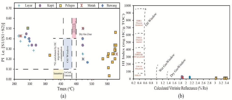
(a) a representative plot of Tmax against PI, which indicates that the hydrocarbons of the studied shales are majorly non-indigenous affiliated to gas. (b) a plot of HI versus %Ro displaying the type and maturity of samples of Belaga Formation.
While the analyzed samples of turbidite shales of the studied area from Pelagus Member, Metah Member, and Bawang Member are at relatively much higher mature stage (dry gas window) with type IV kerogen (Fig. 6b). By using calculated vitrinite reflectance (*Ro%), on the plot of HI versus *Ro% as shown in Fig. 6b, most of the samples come in the gas window (dry), which is consistent with the previous results.
5 Conclusions
Using the Total Organic Carbon (TOC) and Rock-Eval pyrolysis techniques, black shales units from the Belaga Formation were examined for their qualitative and quantitative geochemical characterization. In general, the organic matter richness (TOC) is higher in older three members while it is lower in the two younger members. S1 versus TOC cross plot shows that the hydrocarbons were indigenous in nature. Van Krevelen diagram and other geochemical plots support the results which indicate high variation in TOC values. These measured TOC percentages predict that few members of Belaga Formation are mainly immature (Layar Member, Kapit Member and some shale intervals of Bawang Member), however the other members of Belaga Formation have dry gas generation potential (Pelagus Member and Metah Member). Although, the organic richness (TOC content) of Layar Member, Kapit Member, and Pelagus Member are slightly higher than the Metah Member and Bawang Member, but only Pelagus Member is thermally mature for dry gas generation potential. Tmax values and S1, S2 values verify that paleotemperatures lie in two windows i.e., either immature to early mature or gas mature to over mature. S2 versus TOC cross plot also verify that Pelagus Member has fair genetic potential. Conclusively, the older members (Pelagus and Kapit) show fair organic richness and thermal maturity in dry gas zone.
As the shales were deposited in the deep marine depositional environment, in the course of weathering and oxidation of organic matter prior to deposition, they are related to reworked and recycled parental rocks and thus could have lost organic matter, which may account for the low TOC values. The higher Tmax range of the shales from younger members favors over mature organic matter, which might indicate tectonic involvement. The number of samples are limited in this study due the limited fresh outcrop of unmetamorphosed exposures. Moreover, future petroleum exploration activities in Sarawak can offer subsurface details (in the form of core and well log data) for better understanding of potential petroleum intervals in Belaga Formation of Rajang Group.
Funding Statement
This research received no external funding.
Acknowledgments
The authors would like to thank Institute of Hydrocarbon Recovery, Universiti Tecknologi PETRONAS (UTP), Malaysia, for funding all laboratory analysis through project (YUTP Cost #015LC0-220). The authors gratefully acknowledge the Petroleum Research Fund (PRF Cost # 0153AB-A33), awarded to Dr. Eswaran Padmanabhan.
Declaration of Competing Interest
The authors declare that they have no known competing financial interests or personal relationships that could have appeared to influence the work reported in this paper.
References
- Facies analysis of deep marine channel to lobe deposits of Maastrichtian Layar member of the Belaga Formation, Rajang Group, Sarawak. Warta Geol.. 2019;45:229-230.
- [Google Scholar]
- Geochemistry of Eocene Bawang Member Turbidites of the Belaga Formation, Borneo: Implications for provenance, palaeoweathering, and tectonic setting. Geol. J. 2020 in press
- [CrossRef] [Google Scholar]
- Heterogeneity of the mineralogy and organic content of the Tuscaloosa Marine Shale. Mar. Pet. Geol.. 2019;109:717-731.
- [Google Scholar]
- Evaluation of source rocks of the Campano-Maastrichtian Nkporo group of Anambra Basin, Southeastern Nigeria. Pet. Coal. 2018;60
- [Google Scholar]
- La pyrolyse Rock-Eval et ses applications. Troisième partie. Rev. l'Inst. français du Pétrole. 1986;41:73-89.
- [Google Scholar]
- Provenance of the Cretaceous-Eocene Rajang Group submarine fan, Sarawak, Malaysia from light and heavy mineral assemblages and U-Pb zircon geochronology. Gondwana Res.. 2017;51:209-233.
- [Google Scholar]
- Source potential and reservoir characterization of the Cambay Shale, Cambay Basin, India: Implications for tight gas and tight oil resource development. AAPG Bull.. 2020;104:1707-1749.
- [Google Scholar]
- Haile, N.S., 1974. Borneo. In: Spencer, A.M. (Ed.), Mesozoic- Cenozoic orogenic belts: Data for orogenic studies., vol 4. vol 1. Geological Society, London, Special Publications, pp. 333–347.
- Geologic map of Sarawak. Kuala Lumpur: Director General of Geological Survey of Malaysia; 1992.
- A new upper Paleogene to Neogene stratigraphy for Sarawak and Labuan in northwestern Borneo: Paleogeography of the eastern Sundaland margin. Earth Sci. Rev.. 2019;190:1-32.
- [Google Scholar]
- The Mesozoic tectono-magmatic evolution at the Paleo-Pacific subduction zone in West Borneo. Gondwana Res.. 2017;48:292-310.
- [Google Scholar]
- Petroleum geochemistry and geology (2nd edn.). Freeman and Company: New York, W.H; 1995.
- Geology of North-West Borneo: Sarawak. Brunei and Sabah: Elsevier; 2005.
- Turbidite, debrite, and hybrid event beds in submarine lobe deposits of the Palaeocene to middle Eocene Kapit and Pelagus members, Belaga Formation, Sarawak, Malaysia. Geol. J.. 2019;54:3421-3437.
- [Google Scholar]
- The geology of Sarawak, Brunei and the western part of North Borneo. Vol vol. 1. Government Printing Office; 1960.
- The Geology of Sarawak, Brunei and the Western Part of North Borneo. Vol vol. 3. Geological Survey Department Bulleton: British Territories of Borneo; 1960.
- Liu W (2019) Geochemical Characteristics of Released Organic Matters by Acid Decomposition of Hydrocarbon Source Rocks from Different Sedimentary Basins. Geofluids 2019
- [Google Scholar]
- Maisie, M.A., Salim, A.M.A., Baioumy, H.M., bin, A.b. Talib, J., 2019. Evaluation of shales of the Belaga Formation in Central Sarawak, Malaysia, using the Spectral Gamma Ray method.
- An alternative stratigraphic scheme for the Sarawak Basin. J. Asian Earth Sci.. 1999;17:215-232.
- [Google Scholar]
- Embaluh Group turbidites in Kalimantan: evolution of a remnant oceanic basin in Borneo during the Late Cretaceous to Palaeogene. J. Geol. Soc.. 1998;155:509-524.
- [Google Scholar]
- Murtaza, M., Rahman, A.H.A., Sum, C.W., 2015. The Shallow Marine Succession of Begrih Formation (Pliocene), Mukah Area, Sarawak: Facies, Stratigraphic Characteristics, and Paleoenvironmental Interpretation. In: ICIPEG 2014. Springer, pp. 337–362.
- Peters, K.E., Cassa, M.R., 1994. Applied Source Rock Geochemistry. In: and LBM, Dow, W.G. (Eds.), The Petroleum System-from Source to Trap, vol AAPG Memoir 60. American Association of Petroleum Geologist, Tulsa, pp. 93–120.
- Late Middle Miocene volcanism in Northwest Borneo, Southeast Asia: Implications for tectonics, paleoclimate and stratigraphic marker. Palaeogeogr. Palaeoclimatol. Palaeoecol.. 2018;490:141-162.
- [Google Scholar]
- Sedimentological characterization, petrophysical properties and reservoir quality assessment of the onshore Sandakan Formation, Borneo. J. Petrol. Sci. Eng.. 2020;186:106771
- [Google Scholar]
- Petroleum formation and occurrence—A new approach to oil and gas exploration. Berlin: Springer-Verlag; 1980.
- Petroleum formation and occurrence. Springer Science & Business Media; 2013.
- Geochemistry in petroleum exploration. Springer Science & Business Media; 2013.
- Petroleum and basin evolution: insights from petroleum geochemistry, geology and basin modeling. Springer Science & Business Media; 2012.


