

Translate this page into:
Cryosphere dynamic study of Hunza Basin using remote sensing, GIS and runoff modeling
⁎Corresponding author. jsaleem_93@yahoo.com (Javeria Saleem)
-
Received: ,
Accepted: ,
This article was originally published by Elsevier and was migrated to Scientific Scholar after the change of Publisher.
Peer review under responsibility of King Saud University.
Abstract
Climate change is currently a dangerous phenomenon that has deleterious economic, social and environmental impacts. Climatic fluctuations directly affect the hydrology of an area, which in turn plays a significant role in economy of any country. In Pakistan, River Indus serves as a major fresh water resource, the flow of this river is fed by glaciated ice and snow present in Karakorum, Himalayas and Hindukush ranges. Therefore, it is necessary to evaluate the cryosphere dynamics of the area in order to determine the impact of climate change so that the water resources will be managed efficiently. To this end, Moderate Resolution Imaging Spectroradiometer (MODIS) satellite imagery of 2010 was used for cryosphere study of Hunza Basin. Daily runoff discharge of Hunza Basin, meteorological parameters, remotely sensed data and Digital Elevation Model (DEM) were analyzed synergically in the Snowmelt Runoff Model (SRM). Finally, computed runoff was compared with measured runoff for model calibration. Analysis revealed high glacial melting during simulation period. This indicated that regional warming (caused due to climatic fluctuations which were primarily caused by anthropogenic activities) has affected the hydrology of the area.
Keywords
Climate change
Hydrology
Cryosphere dynamics
Snowmelt runoff model

1 Introduction
Indus irrigation network of Pakistan is among the world’s largest irrigation systems and plays a significant role in the economy of the country (Tahir et al., 2015; Chevallier et al., 2011). Not only agriculture and energy sectors, but significant economic resources are also highly dependent on Indus Basin Watershed (Bashir and Rasul, 2010). Indus water basin is the major hydrological resource of the country and is fed mainly by glaciated ice and snow situated in the northern areas of Pakistan. These ice reserves of Hindukush- Karakoram, Himalayan (HKH) region supply snowmelt to more than 1.4 billion people around the globe (Khan et al., 2015; Minora et al., 2013).
From last few years, these ice reserves have declined to such an extent that they gained significant attention in scientific researches worldwide. Majority of these researches were focused on hydrometeorological conditions of the area (Fowler and Archer, 2006); impact of climate change on river flow (Mukhopadhyay et al., 2015); water resource planning and snow melt analysis (Sharif et al., 2013).
Power and energy supply as well as irrigated agriculture systems are susceptible to the impact posed by climatic fluctuations on water resources since these fluctuations result in the reduced water flow to the river during dry seasons and flooding during wet seasons. Therefore, it is important to evaluate the snowmelt runoff so that the impact of climate change will be studied in detail.
Two methods are available in literature for studying snowmelt runoff i.e. temperate degree day approach and energy balance system (Nagler et al., 2008). Energy balance system can be studied through four main principles i.e. shortwave radiation exchange, convective heat transfer, long wave radiations exchange and advective heat transfers. The inputs that are required to study these principles are dew point temperature, cloud temperature and information on albedo phenomena. These inputs are not available normally therefore degree day factor is preferred for forecasting snow cover and melt runoff (Bashir and Rasul, 2010).
1.1 Study area
Mountain ranges of Himalayan, Karakoram and Hindukush are home to snow and glaciated ice outside the polar region of the world. In Pakistan, majority of the glaciated ice and snow of HKH region are situated in Indus Basin Watershed. This Indus basin watershed comprises of ten distinct river basins i.e. Hunza, Chitral, Gilgit, Astor, Shigar, Indus, Swat, Jhelum, Shyok, and Shingo. Out of these basins, Hunza basin was selected as a study area for current research. In past, Snow cover analysis and runoff dynamics were studied for major Asian rivers including Indus, Ganges, Yellow, Brahmaputra, Salween, Yangtze, Irrawaddy and Mekong on large scale (Immerzeel et al., 2009). Later on cryosphere analysis of Gilgit Basin for year 2003 was done through application of Snowmelt Runoff Model (SRM) (Bashir and Rasul, 2010). Hunza basin was also investigated for year 2000 using SRM.
Current work was also focused on the Hunza Basin for estimating the discharge rate and snowmelt for the year 2010. The total area of basin is 13733 km2 and it lies in the central Karakoram ranges having catchment area of 4463 km2 and altitude of 5000 m. 34% of the total area of basin is covered by glaciers (Akhtar et al., 2009). Hunza Basin Boundary was identified by the location of streamguage installed by WAPDA at Daniyor Bridge Hunza, and the watershed boundary was derived from Digital Elevation Model (DEM) made by Shuttle Radar Topography Mission (STRM) (Fig. 1). After examining the elevation range between the streamguage and the highest point in the basin, total basin relief was calculated to be 2400 m. Hunza Basin was divided into 6 zones for studying runoff simulations as given in Table 1.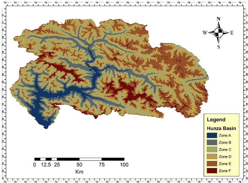
Study area map of Hunza River Basin.
Sr. No
Name of Zone
Elevation (m)
Area (sqkm)
Hypsometric mean elevation (m) (Weighted Average)
1
Zone A
1401–2500
436.30
2166
2
Zone B
2500–3500
1620.08
3142
3
Zone C
3500–4500
4386.29
4106
4
Zone D
4500–5500
7413.25
4998
5
Zone E
5500–6500
1752.66
5712
6
Zone F
6500–7889
179.40
6767
Hunza River Basin is among important tributaries of the Indus water irrigation network system as it accounts for nearly one fifth of the total upper Indus flow. This flow mainly depends upon the accumulated snow at higher altitude and energy balances. Therefore, the aim of this study was to identify the snow cover and estimate the water discharge from Hunza basin during year 2010 using SRM. This study will also be expanded to develop early warning system for severe flooding incident in area under study.
2 Methodology
The methodology adopted in the current study for identifying the snow cover and to find the snow melt runoff rate through SRM was described below
2.1 Data acquisition
The data utilized during the research comprised of qualitative and quantitative data. Qualitative data comprised of satellite imageries of Aster and Moderate Resolution Imaging Spectroradiometer (MODIS) satellite, acquired through registered remote sensing satellite imageries websites. While meteorological and hydrological parameters accounted for quantitative data and were obtained from Pakistan Meteorological department. According to methodology that is discussed in detail below, following data were used to produce the simulation that correlated the water produced from snowmelt and rainfalls with actual gauged discharge of the river. These data were divided into two categories i.e. Basic Data and Derived data mentioned in Table 2.
Data Set
Parameters
Units
Basic Data
Snow cover
Square kilometres (sqkms)
Temperature
Centigrade (oC)
Precipitation
Millimetres (mm)
Derived Data
Runoff Co-efficient
Millimetres per hour (mm/hr)
Degree Day Factor
millimetres water-equivalent per degree per day (mm w.e. °C−1 day−1)
Lapse Rate
°C per kilometre
Recession Co-efficient
Time inverse t−1
2.2 Snow cover identification using MODIS imagery
In order to determine the snow cover of Hunza Basin, MODIS 10A2 terra and Aqua products were used having 500 m resolution. Methodology adopted for this purpose was illustrated through flow chart (Fig. 2).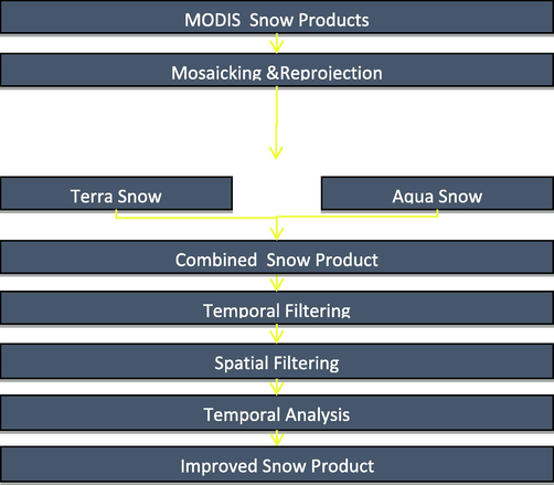
Methodology adopted for snow cover identification.
2.3 Snowmelt runoff model
Daily stream flow in mountain basins, where snowmelt is a major runoff factor, is subjected to simulation and forecast with the help of the Snowmelt-Runoff Model (SRM). Recently, it has been used to determine the effect of changed climate over seasonal snow cover and runoff. SRM can also be applied on mountain basins of varying sizes (so far from 0.76 to 917,444 km2) and elevation ranges. Model run initiates with a known or estimated discharge value and can operate for an unlimited number of days, as long as the input variables i.e. precipitation, temperature and snow covered area are provided. The specific methodology adopted for SRM is outlined in Fig. 3.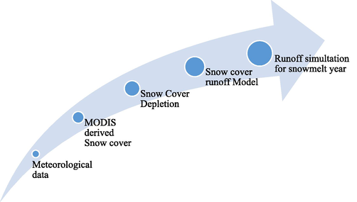
Methodology adopted for snowmelt runoff modeling.
3 Results and discussion
Results obtained from the above-mentioned methodology was divided into two parts i.e. Snow Cover Analysis and SRM analysis.
3.1 Snow cover analysis
In accordance with the aforementioned methodology of snow cover identification (Fig. 2), the results were gathered and are presented in the Table 1 with respect to each zone. Imagery were available with data gaps as clearly showed in table below, therefore the results were interpolated for rest of the days with data gaps. Results showed the decreasing trend in snow cover during dry seasons while in winters it stared increasing. The reason behind this fluctuating trend was temperature variations prevailed in the respective area as indicated by the Meteorological Data (Fig. 5) obtained through Pakistan Meteorological Department.
Snow Depletion Curves for Hunza river basin were interpolated from periodical snow cover that was acquired through MODIS imagery and are shown in Fig. 4. Later on, these values were incorporated as input variable to SRM to obtain the runoff results of study area.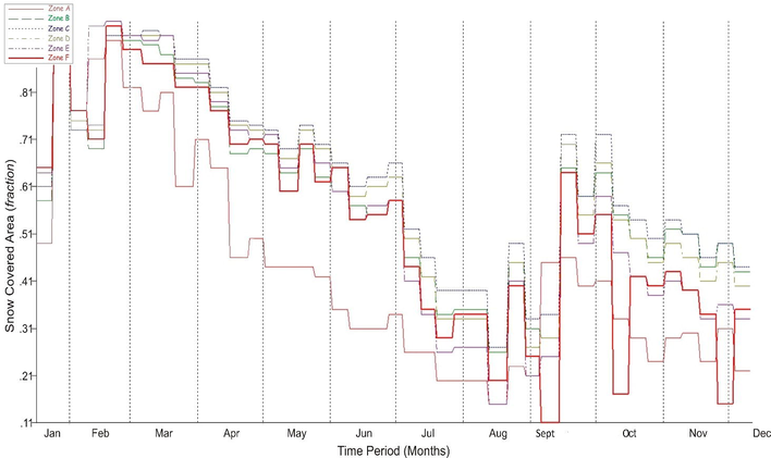
Snow covered area of all zones of Hunza Basin.
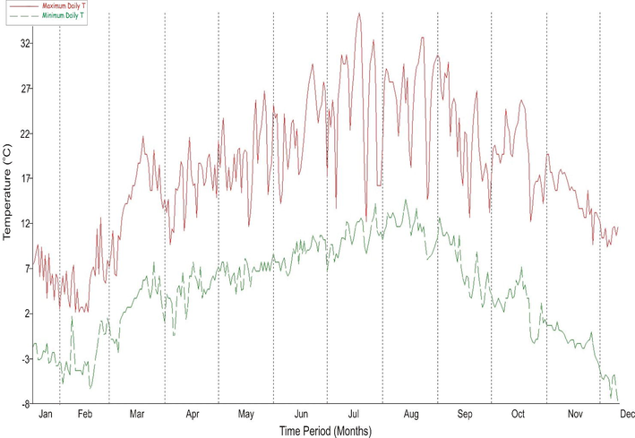
Max/min temperature observed at Hunza observatory in 2010.
3.2 Factors incorporated in SRM
3.2.1 Temperature
Daily average temperature of year 2010 recorded by Pakistan Meteorological Department observatory situated at Hunza Basin was utilized for the model. Snowmelt Runoff Model WinSRM Version 1.11 was programmed in a manner that either it accepted the daily mean temperature or two temperature values on each day: TMax, TMin. The mean temperatures were inferred from the base station elevation to the hypsometric mean elevations of the respective elevation zones. For Hunza observatory, the altitude of the station was entered and temperature data were extrapolated to the hypsometric mean elevations of all zones using the lapse rate (Fig. 5).
3.2.2 Precipitation
Meteorological observatory is situated only at the elevation of 2400 m, so it is very hard to analyze the extent of rainfall of whole area in terrain like Hunza Basin with great elevation ranges. So the precipitation value falls in zone with range of 2400 was copied to all other zones.
3.2.3 Critical temperature
A critical temperature determines whether a precipitation event will be designated as rain (T ≥ TCRIT) or as new snow (T < TCRIT). When the precipitation event comes in form of snow, its delayed effect on runoff is coped in different ways depending on whether it falls over the snow-free or snow-covered area of the basin. The new snow that hits the ground over the previously snow-covered area is assumed to become part of the seasonal snowpack and its effect is included in the normal depletion curve of the snow coverage. The new snow falling over the snow-free area is considered precipitation being added to snowmelt, with this effect prolonged until the next day which is warm enough to cause melting.
3.2.4 Runoff coefficient (c)
This coefficient indicates the losses of water and depends upon the difference between the available water volume and the outflow of the water from the basin. It corresponds to the ratio of the measured precipitation to the measured runoff. Chronological rainfall patterns and runoff proportions over an extended time period can be documented through comparison of runoff coefficient values. If modeling is not operational in first run then Runoff coefficient is found to be the essential choice for adjusting different SRM parameters.
3.2.5 Degree-day factor
This factor was used to convert the total number of degree-days into the daily snowmelt depth.
3.2.6 Temperature lapse rate
Lapse rate was obtained through Automatic Weather Station (AWS) data. Temperature lapse rate used for each respective zones were 0.3, 0.4, 0.5, 1.0, 1.0 and 1.5.
3.2.7 Recession coefficient (k)
Another important parameter for SRM is recession coefficient and was calculated using Eq. (1). This coefficient specifies the decrease of discharge rate in a period without snowmelt or rainfall.
4 SRM analysis
SRM held somehow satisfactory results for the Hunza Basin due to data deficiency. Minor adjustments in Recession Coefficients and Degree Day Factor were made in order to bring satisfactory results. Volume difference between Measured Runoff and Computed Runoff was 58.92% measured by dividing average measured runoff by average computed runoff. Graphical comparison of measured and computed runoff is presented in Fig. 6 given below which is graphical depiction of Runoff (measured vs computed) for year 2010. The obtained results of simulation values were compared with the study conducted at Gilgit Basin for estimating the discharge rate for year 2003 using SRM (Bashir and Rasul, 2010). Similar study was conducted in Upper Heihe River Basin, Gongnaisi River Basinand Tarin China and result indicate that SRM is accurate for stimulating the runoff phenomena (Li and Wang, 2008). The study showed the early onset of snow coverage and snowmelt season that eventually results in redistribution of runoff throughout the snow melt season (Ma and Cheng, 2003). In India Snowmelt runoff was estimated in Beas Basin using SRM with a purpose to plan hydropower generation and water management during non-monsoon period (Prasad and Roy, 2005).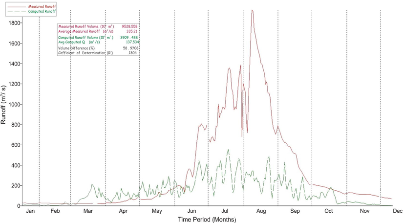
Runoff (Measured vs. Computed) for year 2010.
From above mentioned results it was observe that Hunza Basin depicts the continuous reduction in the snow cover area during summer season as the average temperature in the area increases that results in increasing discharge during summer season. But in cold weather, as reduction observes in the temperature, snow accumulation rate increase and hence rate of discharge decreases. This increase in runoff can also result from increase in annual precipitation in catchment area.
5 Conclusion and recommendations
The feasibility of simulating snowmelt runoff in HKH region watershed was assessed in the current study with limited data availability. Various meteorological parameters were explored with SRM and the model satisfactory simulated the runoff for year 2010 with efficiency of 64%. Study revealed that the simulation model was sensitive to lapse rate and snow albedo parameterization. Moreover, Hunza Basin experience various climatic conditions due to its Altitude, Landscape and Aspect, therefore one value for Degree Day factor cannot be justified for all kind of existing conditions in a zone. Degree day factor is not a constant value it varies with the properties of snow. This was a limitation of SRM model.
In accordance with the aforementioned limitations, it is suggested that more AWS should be installed at various positions and different altitudes so that the more effective picture of temperature and precipitation could be obtain. In current study, only one met observatory data was tested which led many incorporated parameters to be assessed hypothetically. Moreover, it is required to measure snow depth at various points in study area with some more articulated methods that lead to an in-depth consideration of Degree Day Factor. Lastly, it is recommended that this study should be imitated for same and other basin of Indus Water Catchment for numbers of years to obtain a more suitable sketch of inputs and resultant outputs with a purpose to enhance this approach for future forecasting runoff of snow during melting season in Northern Pakistan.
Declaration of Competing Interest
The authors declare that they have no known competing financial interests or personal relationships that could have appeared to influence the work reported in this paper.
References
- Use of regional climate model simulations as input for hydrological models for the Hindukush-Karakorum-Himalaya region. Hydrol. Earth Syst. Sci.. 2009;13(7):1075-1089.
- [Google Scholar]
- Estimation of water discharge from Gilgit basin, using remote sensing, GIS and Runoff Modeling. Pakistan J. Meteorol.. 2010;6(12):97-113.
- [Google Scholar]
- Snow cover dynamics and hydrological regime of the Hunza River basin, Karakoram Range, Northern Pakistan. Hydrol. Earth Syst. Sci.. 2011;15(7):2259-2274.
- [Google Scholar]
- Conflicting signals of climatic change in the Upper Indus Basin. J. Clim.. 2006;19(17):4276-4293.
- [Google Scholar]
- Large-scale monitoring of snow cover and runoff simulation in Himalayan river basins using remote sensing. Remote Sens. Environ.. 2009;113(1):40-49.
- [Google Scholar]
- Separating snow, clean and debris covered ice in the Upper Indus Basin, Hindukush-Karakoram-Himalayas, using Landsat images between 1998 and 2002. J. Hydrol.. 2015;521:46-64.
- [Google Scholar]
- The snowmelt runoff model applied in the upper Heihe River Basin. J. Glaciol. Geocryol.. 2008;5(30):769-775.
- [Google Scholar]
- A test of Snowmelt Runoff Model (SRM) for the Gongnaisi River basin in the western Tianshan Mountains, China. Chinese Sci. Bull.. 2003;48(20):2253-2259.
- [Google Scholar]
- 2001–2010 glacier changes in the Central Karakoram National Park: a contribution to evaluate the magnitude and rate of the“ Karakoram anomaly”. Cryosphere Discussions. 2013;7(3):2891-2941.
- [Google Scholar]
- Rising and falling river flows: contrasting signals of climate change and glacier mass balance from the eastern and western Karakoram. Hydrol. Sci. J.. 2015;60(12):2062-2085.
- [Google Scholar]
- Assimilation of meteorological and remote sensing data for snowmelt runoff forecasting. Remote Sens. Environ.. 2008;112(4):1408-1420.
- [Google Scholar]
- Estimation of snowmelt runoff in Beas Basin, India. Geocarto Int.. 2005;20(2):41-47.
- [Google Scholar]
- Trends in timing and magnitude of flow in the Upper Indus Basin. Hydrol. Earth Syst. Sci.. 2013;17(4):1503-1516.
- [Google Scholar]
- Snow cover trend and hydrological characteristics of the Astore River basin (Western Himalayas) and its comparison to the Hunza basin (Karakoram region) Sci. Total Environ.. 2015;505:748-761.
- [Google Scholar]


