

Translate this page into:
Airborne data processing and 3D modeling of magnetic structures between Nador region and the Chaffarine Islands: Geological significances
⁎Corresponding author at: Hassan First University of Settat, Faculty of Sciences and Technology, Laboratory Physico-Chemistry of Processes and Materials, Research Team Geology of the Mining and Energetics Resources, Morocco. a.miftah@uhp.ac.ma (Abdelhalim Miftah)
-
Received: ,
Accepted: ,
This article was originally published by Elsevier and was migrated to Scientific Scholar after the change of Publisher.
Peer review under responsibility of King Saud University.
Abstract
The Cap of Trois Fourches-Nador-Chaffarine Islands zone (CTF-N-CI) located in the Moroccan Oriental Rif is recognized by Neogene-Quaternary volcanic outcrops. Those later formed volcanic cones and are considered the main source of the huge Nador magnetic anomaly. This study aims to enhance the magnetic context using geophysical techniques and identify the geometry of magnetic sources by performing 3D modeling using Talwani method. We have achieved the following findings: (1) The elaborated residual magnetic map (Rs) that shows three aligned magnetic anomalies. They are oriented W-E and register a maximum intensity of 380 nT. Applying reduction to the pole to (RTP) the Rs map makes the anomalies on the top of their body sources. Thus, we have found that those anomalies have resulted essentially from the Gourougou volcano and Chaffarine Islands volcanoes outcropping in the study area. Except for the middle Pm anomaly, which is related to volcanic rocks of the Kariate Arekmane drillhole. (2) Performing horizontal derivative (HD) technique leads to establishing the edges of the source bodies. Hence, the inversed map of the magnetization distribution proves that the three bodies are homogeneous and probably splintered from a unique mass. (3) The downward up continuation (DC) to different heights (from 500 to 2000 m) indicates the source's depth. Thus, we have demonstrated that the common source could reach 0.6 km of altitude. (4) Finally, we have constructed a 3D Talwani model of the volcanic edifices. The released 3D model demonstrates that the anomalies are related to a very extensive mass of 80 km in length, 20 km in width, 1.3 km in thickness. This model supports that the Neogene-Quaternary volcanism of the study area was fissural and related to the W-E fracture zone of up to 80 km in length. This volcanism was also affected by the sinistral Nekor fault, which probably made the Trois Fourches Cap body isolated from the other volcanic edifices.
Previously mentioned elements probably prove the simultaneous establishment of this large magnetic structure. Moreover, they emphasize the crucial role of the magmatic phenomena which occurred in Northeastern Morocco at the beginning of the Messinian.
Keywords
Magnetic anomaly
3D modeling
Magmatic phenomena
Oriental Rif

1 Introduction
For several years, an important effort have been devoted to studying the magmatic activity of the African margin. The magnetic anomalies of the Alboran Sea have been associated with this magmatic activity since the publication of the aeromagnetic map presented by Galdeano and Rossignol (1977).They delineated linear magnetic styles of the Mediterranean western basin. At the level of the African continent, the authors identified the Nador anomaly (NA) (Anahnah et al., 2009; Tendero-Salmerón et al., 2022) that constitutes our subjectFig. 1..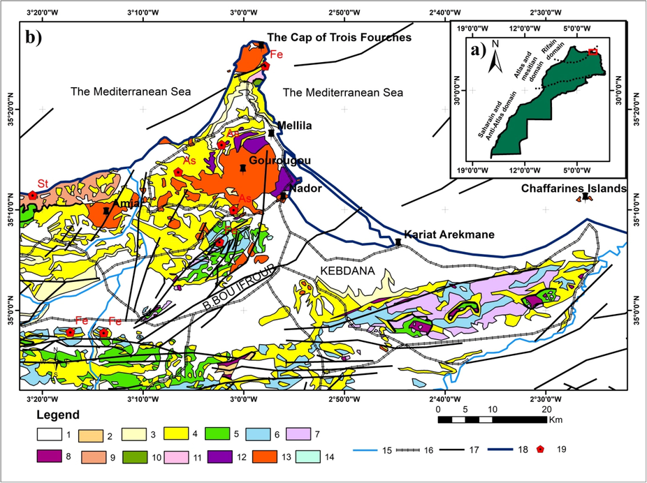
a) The geographic location of the study area. b) Geological map of the study area, modified from the geological map of Morocco scale 1/1000000 (Hollard et al.1985). 1-Quaternary 2-Nappes pre- rifaines 3-Pliocene 4-Miocene 5-Cretaceous 6-Jurassic 7-Lias 8-Trias (saline gypsum) 9-Dinantian Devonian 10-Ordovician- Silurian 11- Mica-Schists of the basement 12- Pliocene and Quaternary Basalts 13-Trachytes Trachy-Andesites and Rhyo-Dacites 14-Lower Miocene Granodiorites 15-Valley 16- Road 17-Faults − 18- The Coast.
NA is located in the Melilla Kert basin (MKB), and it is related to the Neogenic volcanism of this basin. This area has attracted much attention from many researchers. We can cite geological and petrological studies of the Miocene volcanism in eastern Morocco that had been carried out by Hernandez (1983). Then Hernandez and Bellon (1985) have elaborated the K-Ar radiometric chronology of Miocene volcanic event in Eastern Morocco. Moreover, El Bakkali (1995) and El Bakkali et al (1998) have provided more details about the volcanology and magmatology of the Gourougou system. A synthesis of the evolution of the Rif and its foreland since the Neogene is given by Morel (1987). Recently, (Anahnah et al., 2009) have studied the Nador dipole performing measured magnetic field anomalies and susceptibilities. However, very few publications can be found in the literature that discusses the issues of modeling the sources of those volcanoes.
Magnetic anomalies have been analyzed for qualitative interpretation of the extension of peridotite bodies in the western Rif (Bellot, 1985) and the Beni Malek (Michard et al., 1992; El Azzab et al., 1997) located in the central Rif. But, up to date, geophysical studies of magnetic anomalies produced by this volcanism have been weakly examined in the eastern Rif. Anahnah (2009) studied the Nador dipole performing measured magnetic field anomalies and susceptibilities, then added that the available data did not allow determining the geometry of the infill channels coming from the deep crust. Also, Tendero-Salmerón (2022) studied (in a global context) the magnetic anomalies of the Alboran Sea and constructed a 2D forward model of the Nador dipole to quantitatively constrain the geometry and location of their causative bodies of the volcanic bodies. However, the Nador anomaly is still poorly studied because very few publications can be found in the literature that discusses the issues of 3D modeling the sources of those volcanoes.
In this paper, we have shed the lignt on CTF-N-CI volcanism zone and have performed sophisticated geophysical techniques to deliver more details about NA. This anomaly is not only linked to the outcropping volcanoes that appeared on the surface (the Gourougou volcano (GV), the Cap of Trois Fourches volcano (CTF), and the Chaffarine Islands (CI)). But also related to the hidden and deep lavas discovered the Kariate Arekmane drillhole. Some of these volcanoes include rocks of both stages (the calk-alkaline and shoshonitic stage and the late, alkaline stage), such as the GV (El Bakkali et al., 1998). Hence, the occurrence of GV has been related to the tearing of the oceanic slab attached to the African margin.
We aim to delineate the extension of the mentioned volcanoes based on magnetic RTP, discover new structural lineaments using HD transformation, provide more information about the source's depth using DC operation. The cornerstone of this study is the attempt to draw a Three-Dimensional model of the buried magnetic sources and quantify the volume of materials involved in NA by applying the Talwani approach.
We aim to delineate the extension of the mentioned volcanoes based on magnetic transformations, and quantify the volume of materials involved in NA. We also attempt to draw Three-Dimensional model of the buried magnetic sources applying the Talwani approach.
2 Geological setting
The study area is a part of the Eastern Rif Cordillera that was formed by basement rocks of internal and external zones (structured up to early Miocene) and post-trusts basins, Mainly filled by sediments of Upper Tortorian to Quaternary (Guillemin and Houzay, 1982). The study zone is surrounded by the CTF volcanoes to the North, the Amjar massif to the West, the CI to the Est Northwards, and Boudinar buttonholes to the South.
In the present work, we have focused on the CTF-N-CI area study where Neogene-Quaternary volcanism appeared. This volcanism deposited interlayered beds in sedimentary basins and then formed volcanic cones. The essential thing to mention is that volcanic buildings are located near the coastline at boundaries between the thick continental crust of the Rif Cordillera and the thin continental crust of the Alboran Sea.
2.1 The Kert-Melilia sedimentary basin
The KMB is considered the post-nappe basin of the Eastern Rif. This basin is filled with sediments essentially Upper Tortonian to Pliocene (Guillemin and Houzay, 1982). This period is known for setting up great volcanic features like the volcano of CTF and the GV.
The tectono-sedimentary history of the basin at Tortonien are well-described by Morel (1987). He has proposed a scheme of evolution and opening of the basin related to the N45 strike-slip faulting and the N0 and N20 synchronous normal faulting. The opening event involved the aerial activity of the CTF volcano. During this phase, the Tortonian series were deformed. At the beginning of the Messinian, a collapse of the basins was observed along old faults. Also, volcanism was very active throughout the region (but the GV did not exist yet in this period). During the upper Messinian, the southern edge of the basin recorded a shortening event that was oriented E-W to ESE-WNW. It was during this tectonic phase that the GV began to manifest.
Volcanism in the Kert-Mlilia Basin does not exhibit any chronological or geochemical polarity. Therefore, the volcanism is related to a strike-slip system at the eastern edge of the Alboran Sea (Hernandez, 1983). Also, this volcanism is engendered closely in the transverse sliding system operation, which put in contact the Iberian and African plates and affecting the entire lithosphere (Banda and Ansorge, 1980; Hernandez and Bellon, 1985).
2.2 Principal volcanic outcrps
The Neogenic volcanic edifices are spatially associated with the major strike-slip trans-Alboran fault responsible for the opening of these basins (Ait Brahim and Chotin, 1990).
2.2.1 The Cap of Trois Fourches volcano
The small massif of CTF is the last relief before the sea. It is bordered by the Mediterranean Sea on three sides and attains a height altitude of 350 m to the south. CTF is separated from the Tarjat Paleozoic zone by the Ajelman corridor. The CTF uplift is about 6 km in length, following the NNE-SSW direction and 3.5 km in width from West to East, and it reached 400 m of depth. The lavas of the massif are rhyolitic except for some lavas with dacitic composition. Hence they have resulted from the differentiation of a low potassium alkaline magma (Hernandez, 1983). The age provided is 9.6 Ma (Bellon, 1976).
2.2.2 The Gourougou volcano
The GV is the largest volcanic edifice that outcrops in the surrounding plains. It records 881 m of height and a diameter of 30 km. The volcano is accompanied by a cortege of massifs called satellites. They all form a varying shoshonitic. It is constituted by several sub-units (Hernandez, 1983):
-
The Gourougou strato-volcano that covers an area just over 15 km in diameter.
-
The BBI massif that is constituted of small volcanoes spread over a radius of 15 km.
-
The Amjar massif that constitutes an independent edifice shaped 4 km in diameter.
2.2.3 Lavas of Kariate Arekmane drillhole
The lavas encountered in the KA survey has been defined by Wernli (1980) as an underwater casting because it is composed of augite, andesite, and oxyhornblende. Additionally, it is covered by a polygenic breach, pectin lumachilles, and conglomerate rolled pebble beds. On the other hand Hernandez (1983) believes that drilling has penetrated only a domed structure. Azzab (1993) have studied the natural remanent magnetism of volcanic rocks in KA and provided an average inclination of 44.9°. This result strongly agrees with the results found out by Najid (1981) and leads to conclude that the GV and KA volcanoes are highly linked to the same genetic model.
3 Methodology
The aeromagnetic surveys are measured and sponsored by the Ministry of Energy and Mines during the airborne geophysical campaign of North-Eastern of Morocco (Compagnie Géophysique Générale Française (C.G.G.)) since 1965. The aircraft, equipped with a Cesium vapor magnetometer with a sensitivity of fewer than 0.01 nT/s, was flown at a constant altitude in calm weather. The error on the height is 30 m. We focus in this paper on the measurements done in the oriental Rif with a flight altitude of 2600 m, with lines oriented N16°E, spaced 3 km on land areas and 6 km in marine areas. Control lines have N106°E orientation and a spacing of 5 km. The residual magnetic field data extraction was released by digitizing the intersection points among the isovalues curves and lines and the traverses of the potential field data.
4 Results and discussions
We have arrived at defining the corresponding sources of magnetic anomalies and estimating their depths using sophisticated magnetic techniques. Then we have dressed the geometry of these sources based on the Talwani modeling method (Talwani, 1965).
4.1 Source and depths of magnetic anomalies
4.1.1 Residual magnetic anomaly then reduced to the pole
The established residual magnetic map (Rs) shows an immense magnetic signature (called NA) produced by volcanic edifices of CTF-N-CI area (Fig. 2). The NA is oriented W-E and represents an association of three dipoles. Those latter have a normal polarity with lateral extension of 80 km in length and register a maximum intensity of 380 nT. We have applied the RTP technique to the Rs map. It is a powerful method that transforms the observed anomaly into the one that would have been obtained if the magnetization and the local magnetic field were both vertical. It thus allows positioning the observed aeromagnetic anomalies on the top of the bodies of their sources (Baranov, 1957; Baranov and Naudy, 1964). The employed magnetization is defined by a declination of −6.17° and an inclination of 50°. The resulting RTP map (Fig. 3) shows a huge positive anomaly composed of the fusion of three sub-circular anomalies. They are roughly aligned W-E and labeled Pw, Pm, and Pe. We have remarked an increase of intensity from 380 to 440 nT and a Northward displacement of 10 km.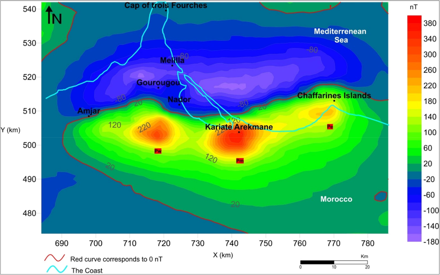
Residual magnetic anomaly of the Nador-Iles Chaffarines zone (NIC). Nw: Western anomaly. Nm: Middle anomaly. Ne: Eastern anomaly.
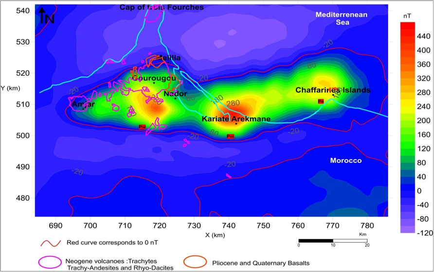
The residual magnetic anomaly reduced to the pole then superposed on volcanoes of the study area.
We have superposed simplified geological features to the illustrated RTP map (Fig. 3). The sources of the Nw and Ne anomalies (that appear on the subsurface) are the GV and the CI volcanoes, respectively. However, there is no evidence for the Nm anomaly on the surface. It reflects the magnetic effect of deep lavas that are fortunately discovered at the Kariate Arekmane drillhole during a surveying company of seven drillholes that reach 694 m of depth.
4.1.2 Horizontal gradient
The HD technique highlights lateral variations in magnetization related to lateral variations in lithology. It’s property is used in structural mapping (Blakely, 1996; Cordell, 1979; Cordell and Grauch, 1985; Nabighian et al., 2005). It is very effective in detecting tectonic structures such as faults (Cordell and Grauch, 1985; El Azzab et al., 2019).The HG map underscores the maxima of gradients that highly reflect geological contacts of the study area (Fig. 4). We have highlighted local maxima by discontinued features, which indicate the edges of magnetic sources. Black ones correspond to the large source that includes three inside sources marked by red ones. Therefore, we have observed a new magnetic lineament in the HD map, which indicates E-W directions. Those latter are different from the mapped faults of the study area that are most oriented NE-SW and NNE-SSW.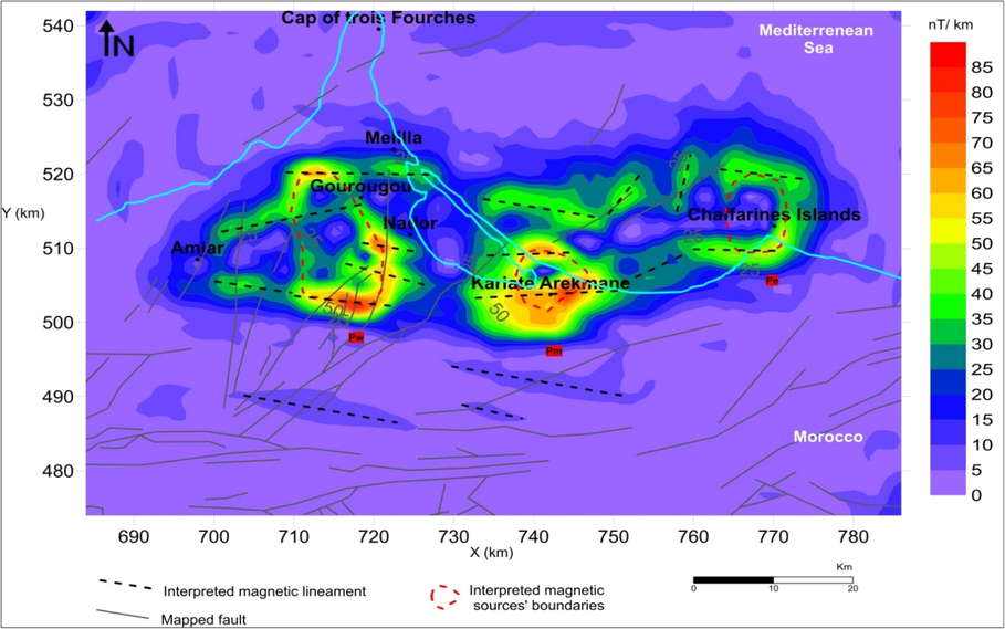
Horizontal gradient of reduced to the pole map highlight magnetic sources’ boundaries.
We have noted also that no positive anomaly appeared around CTF volcano in both the RTP and the HD maps. So, we have explained this by the interference of the low intensity of CTF volcano with the north negative lobe.
4.1.3 Downward continuation
Downward continuation (DC) is used to enhance the responses from sources at a depth by effectively bringing the plane of measurement closer to the sources. The famous advantage of enhancing the potential field by a DC is that the physical dimensions of the transformed field are the same as in the original data (Fedi and Florio, 2002; Tran and Nguyen, 2020; Roy, 1967)). Otherwise, the recognition of a grave oscillatory character in the continued up field map highly indicates the top of the of the source, so it is not theoretically possible to continue through a potential field source. We have applied a DC filter (every 500 m until 2000 m) for the RTP map to estimate the depths of bodies sources (Fedi and Florio, 2002). Fig. 5 shows the resulted maps (Fig. 5a-d). The anomalies isovalues are smoothy and from 500 to 1500 m. But from 1500 to 2000 m, oscillations of high magnitude are illustrated by the decrease of maps resolution.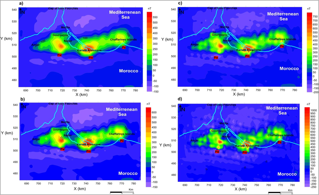
Downward continuation applied to RTP map up to different levels. a) −500 m b) −1000 m c) −1500 m d) −2000 m.
This behavior indicates the sudden enhancement of intensity. It can be explained by the DC operator that arrives at the top level of the source. Thus, we have suggested that the immense body source is situated at 2000 m of altitude. Since the survey level is at 2600 m, the level of 0.6 km m matches the top common source level of the three anomalies.
We have also noted that the gradient on the Southside of the anomalies is so strong. This note informs us about the probability of a deep southern extension of lavas.
The Pw is comparable to the Pm. Their corresponding sources had probably the same shape. Pm anomaly seems to be the smoothest and also the most symmetrical. So the Lavas of KA highly correspond to the top of the common volcanic source.
4.2 Talwani modeling of the magnetic structures from Nador to the Chaffarines Islands
Talwani method (TM) is dedicated to elaborating a 3D model of the magnetic sources (Talwani, 1965; Talwani and Ewing, 1960). It uses irregular polygonal laminas to describe by advantage a body of arbitrary shape. Unlike the Bhattacharyya approach (Bhattacharyya, 1965, 1964), it involves calculating magnetic fields due to prism-shaped bodies, but is limited on using rectangular prisms that are very difficult to adjust for geological structures. The Okabé method also calculates magnetic anomaly produced by a homogeneous polyhedral body composed of polygonal facets (Okabe, 1979). Despite, the use of polyhedral form with their large number makes simulating the shape inadequate.
The Talwani method performs a double integration analytically (DIA) and a single integration numerically (SIN). The body, whose anomaly has to be evaluated, is represented by a polygonal lamina. The DIA is carried out over the horizontal polygonal lamina, while the SIN is subsequently carried out concerning the vertical axis.
We have used the Talwani software (TS) to model the magnetic structures responsible for the three anomalies. We have introduced the program (1) bln extension file that contains different layers for each body to be modeled. We have drawn the shapes of the layers (Fig. 7. a) respecting the anomalies edges found in the HD map and the volcano's contours mapped in the geological map. Then (2) the altitude of each layer is concluded from the DC maps (3). The intensities used (Table 1) are founded by El Azzab (1999). Thus, the TS generates the magnetic map of the introduced prisms. Many tries were done to adjust the shapes to construct the ideal synthetic model (SM) where the anomaly intensities are equal to the RTP map ones (Fig. 6).
Body
N°Roof Depth
(km)Wall Depth (km)
Aimantation
(A/m)
B1
4.5
5
4.2
5
5.635
B2
2.5
2.85
2
2.85
2.95
B3
3.3
3.4
4.2
3.4
3.8
3.8
4
4
4.4
B4
2.6
3
1.8
3
3.6
3.6
4
4
4.5
B5
1.8
2
0.7
2
2.71
2.71
3.2
B6
2.5
2.85
1.2
2.85
2.95
B7
2.1
2.15
1
2.15
2.2
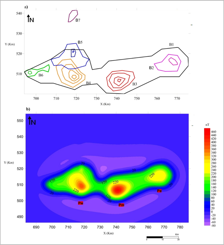
a) Synthetic model of magnetic structures (7 bodies) corresponding to the anomalies of the study area. b) Synthetic magnetic map resulting from the model shown in Fig. 8-A, based on the Talwani method.
The method of inverting the magnetization is published by Gibert and Galdéano (1985) applies the operator “inverse layer magnetization”. This method relies on the convolution of the magnetic anomaly map initially reduced to the pole. We have adjusted the width of the equivalent layer to get magnetization intensities. They should be equal to the ones measured in the borehole samples. Finally, the resulting magnetization values are obtained by inversion distributed in the area. Then they are assigned to the synthetic bodies.
The elaborated 3D Talwani model of magnetic field distribution (Fig. 7) contains seven bodies that are 3D simulation of the three anomaly sources. Those bodies represent lithological sets that are more magnetized than their surrounding formations. The 3D model shows a gigantic body-source (B1) oriented W-E characterized by (of the magnetic bodies) 80 km in length, 20 km in width, 1.3 km in thickness, and 1.9 km depth. B3 magnetic body records the higher intensity of 440 nT, and B7 gives the lower intensity 120 nT. The B7 related to CTF volcano is isolated to the north and located outside the global source without a linke to other bodies on the sub-surface. Therefore, we have suggested that CTF volcano is cut and moved away by tectonic event.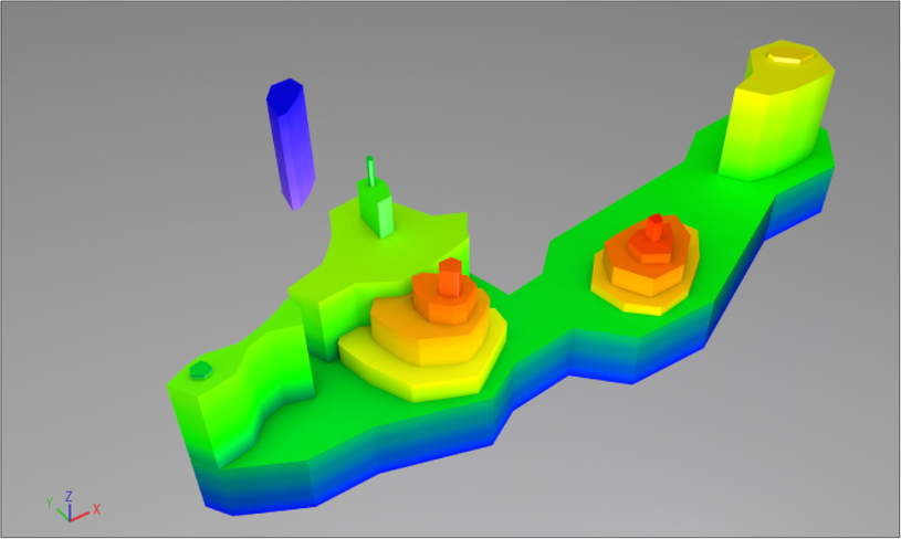
3D Talwani model of volcanic edifices resulting from the synthetic magnetic map Bodies above Kariate Arekmane and Nador.
4.3 Upward continuation of the Talwani synthetic model
UC is a convolution of the original map with a geometric operator of upward continuation at the level of vertical continuity of the field (Gibert and Galdeano, 1985). UC operator filter is a pass-low wavenumber, which reduces the high frequency related to shallower sources and emphasizes the frequency of deeper sources.
Performing UC to 5 km for both calculated Talwani synthetic map and observed magnetic field maps has proved the existence of a common base of the three volcanoes. The shared base I looked inevitable and restrained (Fig. 8).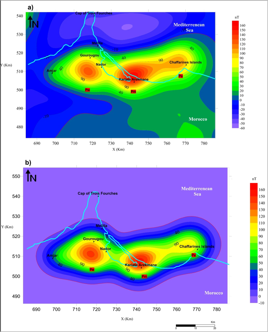
Upward continuation to 5 km of both RTP map. a) and Talwani synthetic map, b) Flight altitude = 2.6 km.
The interpretation of the aeromagnetic field of the CTF-N-CI zone has characterized the presence of a gigantic NA that is oriented W-E (Galdeano and Rossignol 1977, Anahnah 2009, Víctor Tendero-Salmer ́ 2022). Coupling the RTP filtring technique with geological information has gathered that NA embodies three anomalies (Pe,Pm,and Pw). Those later are related to the prolongation of the volcanic rocks outcropping at the onshore area (the GV and the CTF) and extending Eastwards offshore up to CI volcanoes. However, we have found that the Nm that register the highest intensity of 380 nT do not show any subsurface lithological feature. It is highly linked to the KA lavas deeply discovered at 694 m (El Azzab 1999). Hence we have suggested that the three anomalies are fragments an extensive mass. Furthermore, we have proved that the root of the three volcanoes was unique.
The elaborated HD map has illustrated magnetic boundaries that are 80 % oriented W-E. So there is a contradiction between mapped faults orientation and interpreted magnetic lineament. This observation supports that the Neogene volcanism of CTF-N-CI was fissural but cannot be related to the subsurface structures. Otherwise, it certainly was linked with the W-E fracture zone.
The resulting 3D Talwani model (argumented and evaluated by DC technique) delivers a 3D simulation of the deep connection among the GV, the CTF, and the CI volcanic edifices by a kilometric scale elongated E-W basic intrusion (B1) parallel to the African coast. This basic intrusion was structured by W-E tectonic zone and had no relationship with faults or folds, which are not W-E oriented (Víctor Tendero-Salmer ́ 2022).
5 Conclusion
All previously geophysical conclusions have defended the theory of the simultaneous establishment of this large magnetic structure since they have the same source. Missenard (2006) has also seen that Mio-Plio-Quaternary alkaline volcanism of oriental Rif is devoided of crust contamination because their geochemical signatures comparable to the intra-oceanic basalts. He has suggested the contribution of the ‘‘so-called’’ Moroccan Hot Line, extending from the southeast of Spain to the Canary Islands (Chalouan et al., 2008). Maury et al. (2000) has suggested that there is a direct link between the magmatic evolution and the subduction of the African plate ended by the pullout of the oceanic slab. This paper will be an important document for paleogeographic studies for Northeastern Morocco because it underlines the importance of the magmatic phenomena that has been occurred in northeastern Morocco at the beginning of the Messinian. Furthermore, the present work gives new magnetic styles, which will be very important for iron prospection in the study area.
Acknowledgements
Deep thanks and gratitude to the reviewers for careful revision and their helpful comments and recommendations, which improved the quality of this paper. We are grateful to the Ministry of Energy and Mining of Rabat, for providing us aeromagnetic data used in this study.
Disclosure of Funding
This research did not receive any specific grant from funding agencies in the public, commercial, or not-for-profit sectors.
Declaration of Competing Interest
The authors declare that they have no known competing financial interests or personal relationships that could have appeared to influence the work reported in this paper.
References
- Oriental Moroccan Neogene volcanism and strike-slip faulting. J. Afr. Earth Sci.. 1990;11:273-280.
- [CrossRef] [Google Scholar]
- Anahnah, F., Galindo-Zaldívar, J., Azzouz, O., Ruano, P., Chalouan, A., Pedrera, A., Ruiz-Constan, A., Bouregba, N., 2009. The Nador dipole: one of the main magnetic anomalies of the NE Rif. Trab. de Geol., 29.
- EL Azzab, D., 1999. Contribution du géomagnetisme à l'étude de la mise en place du magnétisme atlaso-rifain post-paleogène.Thèse d'Etat, Faculté des sciences et techniques FES-SAIS, pp. 227-247.
- EL Azzab, D., 1993. Apport de geomagnétisme à la géologie du Rif externe (Maroc). Mise en place des péridotites des Beni-Malek. Thèse, Université Paris XI, pp. 1-192.
- Crustal structure under the central and eastern part of the Betic Cordillera. Geophys. J. Int.. 1980;63:515-532.
- [CrossRef] [Google Scholar]
- A new method for interpretation of aeromagnetic maps: pseudo-gravimetric anomalies. Geophysics. 1957;22:359-382.
- [CrossRef] [Google Scholar]
- Numerical calculation of the formula of reduction to the magnetic pole. Geophysics. 1964;29:67-79.
- [CrossRef] [Google Scholar]
- Bellon, H., 1976. Séries magmatiques néogènes et quaternaires du pourtour de la Méditerranée occidentale, comparées dans leur cadre géochronométrique. Implications géodynamiques (PhD Thesis). Université Paris-Sud Orsay.
- Etude gravimétrique du Rif paleozoïque: la forme du massif des Beni- Bousera. Académie de Montpellier: Université des Sciences et Techniques du Languedoc; 1985.
- Magnetic anomalies due to prism-shaped bodies with arbitrary polarization. Geophysics. 1964;29:517-531.
- [CrossRef] [Google Scholar]
- Two-dimensional harmonic analysis as a tool for magnetic interpretation. Geophysics. 1965;30:829-857.
- [CrossRef] [Google Scholar]
- Potential theory in gravity and magnetic applications. Cambridge University Press; 1996.
- The Rif Belt. In: Continental Evolution: The Geology of Morocco. Springer; 2008. p. :203-302.
- [CrossRef] [Google Scholar]
- Cordell, L., Grauch, V.J.S., 1985. Mapping basement magnetization zones from aeromagnetic data in the San Juan Basin, New Mexico, in: The Utility of Regional Gravity and Magnetic Anomaly Maps. Society of Exploration Geophysicists, pp. 181–197. Doi: 10.1190/1.0931830346.ch16.
- Cordell, L., 1979. Gravimetric expression of graben faulting in Santa Fe Country and the Espanola Basin, in: New Mexico Geological Society Guidebook, 30^< Th> Field Conference, New Mexico, pp. 59–64.
- Prolongement en profondeur d'une ecaille ultra-basique allochtone: traitement des donnees aeromagnetiques et modelisation 3D des periodotites des Beni-Malek (Rif, Maroc)(8 fig., 4 tabl.) Bulletin de la Societe Geologique de France. 1997;168:15-24.
- [Google Scholar]
- Geological interpretation of the rifian foreland gravity anomalies and 3D modeling of their Hercynian granites (Northeastern Morocco) J. Afr. Earth Sci.. 2019;150:584-594.
- [CrossRef] [Google Scholar]
- El Bakkali, S., 1995. Volcanologie et Magmatologie du systeme du Gourougou (Rif Oriental, Maroc)[volcalonogy and magmatology of gourougou system (eastern Rif, Morocco)]. PhD, University of Blaise Pascal Clermont-Ferrand II (in French).
- Caractérisation et stratigraphie de dépôts volcanoclastiques marqueurs dans le Miocène supérieur du bassin de Melilla-bas Kert (Rif oriental, Maroc) Comptes Rendus de l’Académie des Sciences - Series IIA - Earth Planet. Sci.. 1998;327:93-100.
- [CrossRef] [Google Scholar]
- A stable downward continuation by using the ISVD method. Geophys. J. Int.. 2002;151:146-156.
- [CrossRef] [Google Scholar]
- Assemblage a altitude constante des cartes d’anomalies magnetiques couvrant l’ensemble du bassin occidental de la Mediterranee. Bull. Société Géologique de France. 1977;S7-XIX:461-468.
- [CrossRef] [Google Scholar]
- A computer program to perform transformations of gravimetric and aeromagnetic surveys. Comput. Geosci.. 1985;11:553-588.
- [CrossRef] [Google Scholar]
- Etudes géologiques sur la Chaîne du Rif. III: Le Néogène post-nappes et le Quaternaire du Rif nord-oriental. Stratigraphie et tectonique des bassins de Mellila, du Kert, de Boudinar et du piedmont des Kebdana. Notes serv. géol. Maroc 1982:7-238.
- [Google Scholar]
- Le volcanisme miocène du Rif oriental (Maroc): Géologie, pétrologie et minéralogie d’une province shoshonitique (Doctoral dissertation). Paris VI (France): Université Pierre et Marie Curie; 1983.
- K-Ar radiometric chronology of Miocene volcanics in eastern Morocco: tectonic and magmatologic implications. Revue de Geologie Dynamique et de Geographie Physique. 1985;26:85-94.
- [Google Scholar]
- Hollard, H., Bronner, G., Marchand, J., & Sougy, J. (1985). Carte géologique du Maroc au 1/1.000.000. Notes et Mémoires du Service Géologique Maroc. 260.
- Post-collisional Neogene magmatism of the Mediterranean Maghreb margin: a consequence of slab breakoff. Comptes Rendus de l’Académie des Sciences-Series IIA-Earth and Planet. Sci.. 2000;331:159-173.
- [CrossRef] [Google Scholar]
- A serpentinite ridge in a collisional paleomargin setting: the Beni Malek massif, External Rif, Morocco. Earth Planet. Sci. Lett.. 1992;113:435-442.
- [CrossRef] [Google Scholar]
- Missenard, Y., 2006. Le relief des Atlas Marocains: contribution des processus asthénosphériques et du raccourcissement crustal, aspects chronologiques. (PhD Thesis). Université de Cergy Pontoise.
- Morel, J.-L., 1987. Evolution récente de l’orogène rifain et de son avant-pays depuis la fin de la mise en place des nappes (Rif, Maroc) (PhD Thesis). Paris 11.
- The historical development of the magnetic method in exploration. Geophysics. 2005;70:33ND-61ND.
- [CrossRef] [Google Scholar]
- Paleomagnetism Of Quarternary And Miocene Lavas From North-East And Central Morocco. J. Geophysics. 1981;49:149-152.
- [Google Scholar]
- Convergence in downward continuation for some simple geometries. Geophysics. 1967;32:853-866.
- [CrossRef] [Google Scholar]
- Computation with the help of a digital computer of magnetic anomalies caused by bodies of arbitrary shape. Geophysics. 1965;30:797-817.
- [CrossRef] [Google Scholar]
- Rapid computation of gravitational attraction of three-dimensional bodies of arbitrary shape. Geophysics. 1960;25:203-225.
- [CrossRef] [Google Scholar]
- Tendero-Salmerón, V., Galindo-Zaldivar, J., d'Acremont, E., Catalán, M., Martos, Y. M., Ammar, A., & Ercilla, G. 2022. New insights on the Alboran Sea basin extension and continental collision from magnetic anomalies related to magmatism (western Mediterranean). Marine Geol., 443,106696.Doi: 10.1016/j.margeo.2021.106696.
- A novel method for computing the vertical gradients of the potential field: application to downward continuation. Geophys. J. Int.. 2020;220:1316-1329.
- [CrossRef] [Google Scholar]
- Le Messinien à Globorotalia conomiozea (foraminifère planctonique) de la côte méditerranéenne marocaine. Eclogae Geol. Helv.. 1980;73(1):71-93.
- [Google Scholar]
Appendix A
Supplementary data
Supplementary data to this article can be found online at https://doi.org/10.1016/j.jksus.2022.102380.
Appendix A
Supplementary data
The following are the Supplementary data to this article:


