

Translate this page into:
Green space settlement landscape optimization strategy under the concept of ecological environment restoration
⁎Corresponding author at: College of Art, Xi'an University of Architecture and Technology, 710055, Xi'an, Shaanxi, China.
-
Received: ,
Accepted: ,
This article was originally published by Elsevier and was migrated to Scientific Scholar after the change of Publisher.
Peer review under responsibility of King Saud University.
Abstract
This article focuses on the urban development strategy and urban overall planning under the concept of ecological environment restoration, and determines planning guidance, planning principles, and planning goals. First of all, the urban green space settlement landscape design based on the ecological concept is jointly carried out from the three aspects of natural landscape, artificial landscape and human landscape. Secondly, in the research on the structural characteristics of urban green space and its temporal and spatial evolution, based on the four phases of remote sensing images, the application of remote sensing and GIS and other spatial information technologies, with the assistance of basic data and sample plot surveys, has achieved a survey. Comprehensive analysis and evaluation of the evolution of the quantity structure of urban green space, the evolution of vegetation coverage, and the evolution of vegetation structure are given. The results of the experiment found that the total area of urban green space has shrunk during the study period. Through summarizing and summarizing, the basic design process and elements are derived: the natural landscape emphasizes its ecological diversity from the green space settlement landscape form, slope protection, topography and planting design. In summary, the green space settlement landscape design of natural landscape, artificial landscape, and human landscape is more scientific and complete. Based on the analysis and evaluation of the natural conditions, social economy, urban nature and development planning, the current situation of the urban water system and other background data in the planned area, with the theoretical guidance of landscape ecology and environmental behavior, the case study combines the landscape ecology. The restoration design is used to test the application methods of ecological landscape restoration.
Keywords
Ecological environment
Restoration concept
Green space
Landscape optimization

1 Introduction
The acceleration of urbanization has destroyed the natural environment of the city. As the green space of urban green space settlement is a green space to improve the ecological environment of the city, its landscape planning and design has been paid more and more attention. As a result of the alienation, citizens increasingly appreciate the natural and wild interest in the green space settlement landscape. As a heterogeneous landscape environment, ecological water patches play an important role in landscape planning and design (Huang et al., 2018). While satisfying the visual effects of the landscape, the sound environment quality has gradually become an important aspect of people's concern. This article focuses on the green space settlement landscape of regional urban green space settlement landscape ecological water patches, and advocates the integration of traditional visual landscape and soundscape experience based on the green space settlement landscape model. Therefore, it discusses the green space settlement landscape and ecological water body. The relationship between patch landscape factors is particularly important (Lu and Fu, 2019; Yu et al., 2020; Gao et al., 2019; Yang et al., 2020).
From a practical perspective, based on the difficulties and problems encountered in the restoration of urban green space settlement landscapes studied in this article, specific solutions and theoretical guidance are summarized. The rapid development of urbanization process has not only neglected the deterioration of the urban ecological environment, and neglected the protection of the urban green space settlement landscape ecological environment, but also blindly created urban garbage to destroy the ecological environment, causing the urban ecological environment to be greatly affected. It also seriously affected the landscaping of the urban green space settlement landscape (Wirth et al., 2018; Nor et al., 2017; Lennon et al., 2017). The research content of this paper is mainly based on the problems encountered in the green space settlement landscape ecology and slope protection under the large ecological environment of the city. Rehabilitation design for the existing state proposed renovation methods, principles and research routes; with the theoretical support of landscape ecology and environmental behavior, the landscape restoration design of the urban green space settlement landscape ecological landscape (Cameron et al., 2020; Kronenberg et al., 2020; Shepley et al., 2019).
On the basis of field investigation, the article focuses on the evaluation experiment of the acoustic comfort of the internal and external sound of the green space settlement landscape under laboratory conditions, in order to explore the landscape background type, hydrophilic distance, animal and human of the ecological water patch. The relationship between the three aspects of the activities of the landscape and the landscape of the green space settlement. In order to enhance the real presence of the landscape, the experiment combines listening and watching 3D landscape images to reproduce the green space settlement landscape model. In the statistical analysis of the experimental results, firstly, the single-factor analysis of variance was used to test the difference between the internal sound of the green space settlement landscape and the landscape factors, and it was found that the natural sound inside the green space settlement landscape has the highest acoustic comfort under the influence of various landscape factors. The acoustic comfort of activity sound and signal acoustic elements both show differences, and when the acoustic elements are highly compatible with the landscape factors, the acoustic comfort is relatively high. The relationship between the constructed landscape pattern index and biophysical parameters and the surface temperature shows that the green space patch density index and the nearest neighbor distance index are positively correlated with the surface temperature in a binary upper parabola. The negative logarithmic transformation relationship, the normalized difference impervious surface index and the surface temperature of the sample area show a one-variable linear significant positive correlation, and the vegetation coverage and the surface temperature show a one-variable linear significant negative correlation. When analyzing the influencing factors of urban thermal environment, it is found that there is a positive logarithmic conversion relationship between urban population density and urban surface temperature.
2 Related work
Although the research content of green space settlement landscape at home and abroad has become more and more extensive, domestic related research often only stays at the apparent level of exploration, lacks research data support and rigorous experimental demonstration, and lacks in-depth influencing factors mining and theoretical results. In addition, researchers in every discipline related to green space settlement landscapes abroad generally have their own methods of studying green space settlement landscapes. For example, sociologists study green space settlement landscapes from the perspective of social culture, and architects from the perspective of spatial modeling, and physicists consider from the perspective of acoustic parameters. Although results have been achieved, “academic intersection” is difficult to form, so there is no systematic green space settlement landscape theory system (Yan-gang et al., 2021; Arroyo-Rodríguez et al., 2020; Wu et al., 2019; Strassburg et al., 2020).
Strassburg (Hansen et al., 2019) puts the engineering design of water conservancy projects in the first place and does not accept the ecological and natural design of the green space settlement landscape, which has resulted in the hard, channelized, lifeless and self-purifying ability that is everywhere today space settlement landscape. Green space settlement landscape water system, revetment, vegetation, and greening are the main fronts for improving the urban environment. While solving urban water conservancy projects, it is directly related to urban green space settlement landscape landscape, urban ecological environment, and urban texture and urban culture, etc. At the same time, the planning and design of Hansen (Guo et al., 2019) must be on the basis of not obstructing the basic functions of the green space settlement landscape, such as flood control, drainage, navigation, water source, etc. The design or renovation must be carried out based on the implementation of relevant norms and regulations of water conservancy engineering facilities; secondly, as the trend of green space settlements landscape transformation in the world becomes more and more mature, green spaces that focus on ecology and landscape. The trend of settlement landscape transformation is becoming clearer. Therefore, based on water conservancy engineering facilities, the study of green space settlement landscape planning and design that integrates ecology and landscape construction is particularly important. Grasping the status quo of the construction of artificial water systems in northern cities, Guo (Wu et al., 2019) analyzed the advantages and disadvantages of artificial water systems, and preliminarily discussed the construction methods and methods of urban artificial water systems in northern areas, so as to put forward forward-looking development ideas for urban artificial water system landscape planning and reconstruction in northern areas. Wu (Nitoslawski et al., 2019)'s main conclusions are as follows: In terms of practice, we should pay attention to the concretization of the concept; the formulation of green space settlement landscape improvement plan and the implementation of specific projects should be adapted to local conditions, time and type, and in accordance with the characteristics of the specific green space settlement landscape. Time and space should be grasped; the construction of artificial ecological green space settlement landscape must implement the principles of ecology and overall optimality, and people-oriented principles; the construction of artificial ecological green space settlement landscape has a long-term nature; focus on comprehensive slope protection, biological ditches, and water quality ecology.
Nitoslawski (Wu et al., 2018) defines open space as: whether it is surrounded by walls, there are no buildings, or less than 5 % of the land is for buildings, and the remaining part has been built into a garden, or is for recreational use, or is unused, emphasizing it is a garden space with leisure functions; the American planning community defines urban green open space as: areas in the city where natural landscapes are maintained, or restored natural landscape areas, including recreational areas, protected areas, scenic spots, or cities. The land preserved during the construction process emphasizes the environmental space with natural characteristics (Wei et al., 2020; Verhagen et al., 2018; Li et al., 2019; Xu et al., 2018). The Japanese planning community believes that: green open space refers to urban roads, rivers, canals and other public construction sites, open spaces not covered by buildings, emphasizing green spaces not covered by buildings. On the one hand, open space refers to a space that is relatively open, less enclosed and has fewer space constraints; on the other hand, it refers to a space that is open to the public and serves the majority of the people, including green space settlement landscapes, gardens and greenery landscapes, etc., as well as urban areas. It can be seen that scholars in different fields around the world have different definitions of open space, and there are differences in their conceptual understanding, but its basic connotation and functions emphasize naturalness and openness, including both natural space and leisure. The concept of urban green space emphasizes the ecological integrity and spatial integrity of green space, and can better express the concept of regional integrated development and the interconnection between ecological processes and functions (Li et al. (2019), Kim et al. (2017)).
3 Concept level of ecological environment restoration
3.1 Environmental clustering
Degradation of ecosystem functions, changes in structure, and disorder of ecological and natural relationships can all be understood as damage to the ecosystem. Therefore, the restoration process is to restore the uncoordinated relationship of the entire ecosystem to a coordinated relationship. Due to the continuous influence of human activities and the complexity of the ecological environment, it is unrealistic to restore the destroyed ecosystem to its original state. Therefore, the restoration of the ecosystem can only be done on the existing basis. So that the ecological function of the ecosystem can be restored to a certain extent. The restoration of the ecosystem includes a series of physical, chemical and biological treatment processes, so as to control the development direction of the ecosystem and realize the restoration of the ecosystem.
There are a large number of green vegetation around the base, forming a point-to-surface relationship with the strip-shaped base, and the east side of the base corresponds to the corridor. The upstream sides of the landscape within the base range are natural woodlands and artificially planted forest landscapes, the middle reaches of the landscape intersect the green belts near the South-to-North Water Diversion area, and the downstream sides of the landscape are basically farmland landscapes. The current vegetation is mainly poplar forest and paulownia, and there are all kinds of trees and shrubs, rich in species, and good vegetation conditions.
According to the characteristics of the highest biodiversity and the strongest heterogeneity in the middle reaches of the landscape revealed by the landscape continuum theory, the ecological restoration of the middle reaches of the landscape should be analyzed and considered in the green space settlement landscape urban green space settlement landscape design. According to the flood pulse theory, the flood pulse is the driving force of the landscape horizontal material exchange. When ecological restoration of urban rivers, the landscape sections in submerged, semi-submerged and flooded areas should be paid special attention.
Based on the understanding of the landscape ecosystem from the perspective of the space and time dimensions proposed by the four-dimensional system theory, when designing the green space settlement landscape, the urban green space settlement landscape landscape, the vertical deep pools, shallows, and reefs are important for the landscape ecology. The components of the structure are reasonably arranged and used effectively.
3.2 Spatial settlement analysis
Regarding the classification of the “patches” in the urban green space settlement landscape as the structural unit of the landscape, this paper uses the difference in ecological function as the standard, and emphasizes the definition of the ecological water patches that are the focus of the experimental part as the landscape with natural or semi-natural characteristics. Semi-natural vegetation covers core ecological patches or buffer ecological patches with strong ecological functions; in addition, because the urban green space settlement landscape water patch landscapes investigated in this paper have artificial characteristics and weak natural ecological functions, from Table 1 which is defined as using functional water patches. In order to correspond to “ecological water patches”, it is hereinafter referred to as “artificial water patches”.
Ecological functions
Settlements 1
Settlements 2
Settlements 3
Settlements 4
1
−0.78639
0.02532
0.33291
0.03393
2
1.82087
0.00652
0.24699
0.02986
3
−0.27033
0.00268
0.46992
0.49294
4
9.99147
0.00183
0.51265
0.39901
5
−0.78639
0.02532
0.33291
0.03393
By summarizing the collected related literature and data, and further summarizing and comparing the vertical and horizontal aspects. At the same time, combined with the field investigation of the example project, combined with other case analysis, it is classified, summarized and comprehensively analyzed, and it provides a reference for how to make the urban green space settlement landscape planning based on the ecological concept more reasonable and the design more beautiful.
Green space settlements, landscape urban green space settlements, landscape ecological restoration should be guided by restoration ecology restoration methods. The goal of ecological restoration is not to establish a new ecosystem, nor is it an attempt to restore the landscape's ecosystem to its most primitive state. Instead, according to the actual situation of the urban green space settlement landscape ecosystem, various methods and means of ecological restoration are used to gradually restore the ecological function of the urban green space settlement landscape ecosystem.
3.3 Environmental noise factor analysis
The environmental entrance landscape design adopts a large-scale approach to create a good visual experience with high-quality entrance landscape. The design form combines the shape, color and style of the building for unified planning. The core landscape node is set in the entrance area, with water features, sculptures, and paving. The mixed configuration of multiple landscape elements such as decorations and lamps reflects the combination of nature and humanity.
Seasonal restoration and long-term restoration are two aspects of urban green space settlement landscape restoration in the time dimension. Among them, seasonal restoration refers to the comprehensive consideration of different seasonal landscapes, such as seasonal changes in plant landscapes. Seasonal restoration requires comprehensive consideration of the landscape features of green space settlements at different time periods, rather than just creating a temporary view.
Long-term restoration means that after the initial intervention of artificial restoration, Fig. 1 promotes green space settlements, landscape urban green space settlements, and landscapes to form a virtuous cycle of the ecosystem in a longer time dimension through the formation of the right direction of guidance. Finally, a low-cost, low-maintenance and sustainable green space settlement landscape will be realized.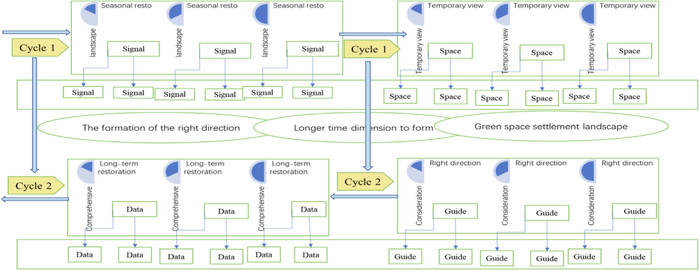
Spatial distribution of ecological environment noise.
The urban green space settlement landscape planning and design based on the ecological concept is not a problem that can be solved by the single discipline of gardening. It must be an engineering type that can be carried out by combining the knowledge of ecology, water conservancy, urban planning, engineering, soil, plants and other disciplines. We use the learning and application of comprehensive disciplines to come up with optimized solution strategies. Therefore, when researching, one should not only focus on the subject of landscape design. It is necessary to synthesize various related disciplines and relevant knowledge systems to provide divergent thinking for research and propose optimal design solutions.
4 Construction of a green space settlement landscape optimization model
4.1 Spatial distribution of ecological environment
In the ecological environment space, grass slope revetment is a common way of slope greening. It is easy to plant or lay and has a high coverage rate. The rhizome can slow down surface runoff and reduce the erosion and erosion of river banks by water. Larger lawns can also can conserve water, has the effect of regulating the microclimate and improving the environment, and is of great significance in improving the ecological environment and preventing soil erosion.
The arbor-type revetment method is to plant on the slope bank by selecting strong water-tolerant trees. Its biggest advantage is that it can achieve the dual effects of vertical greening and preventing soil erosion by planting trees. It is generally suitable for water-tolerant plants and rich land resources. The composite revetment is to plant multiple types of plants such as ground cover, shrubs, and trees through a hierarchical planting method, so as to achieve the functions of conserving water, enriching ecological resources, and conserving water and soil.
For urban green space settlement landscape landscape, green space settlement landscape green space settlement landscape has become a new mode of green space settlement landscape replenishment. Green space settlement landscape is a special green space settlement landscape replenishment method, which requires ecological restoration measures, as well as artificial regulation and management, to strictly control water volume and water quality, so as to realize the protection and reuse of water resources. The construction of green space settlement landscape urban green space settlement landscape can not only alleviate the current situation of urban water shortages, but also facilitate the construction of a beautiful urban environment. While protecting the ecological environment, it provides residents with recreational and entertainment venues. It has important reference value in landscape design.
4.2 Applicability of green space
The ecological green space settlement landscape fully complies with the design principles of adapting measures to local conditions, and the rigid landscape and revetment form are designed according to the current topography. For example, in order to meet the functional requirements and road construction, the artificial reconstruction of the terrain should also follow the trend, reasonably select the design elevation and contour shape, and try to ensure that the minimum amount of earthwork is used to reduce the damage to the original terrain and landform.
People have natural hydrophilicity, so the hydrophilic river bank is an important part of the green space settlement landscape, and it has become one of the places that attract people to visit. Therefore, in the design, there are walking trails, wooden plank roads, stepping steps, etc., while improving people's participation, it is necessary to minimize the impact on the natural slope.
According to the difference of habitat environment, the urban landscape green space settlement landscape can be divided into four parts horizontally: green space settlement landscape, waterfront zone, river beach land and land transition zone, among which the river bank line in the wet season to the shallow water environment area zone. The area from the flood level to the river bank line in the high-water season is a river beach, and the area from urban construction land to the flood level is a land transition zone.
In different urban green space settlement landscapes, although there are certain differences in the proportions of these four parts, these four parts should be complete in any horizontal cross-section of the landscape. Therefore, Fig. 2 should take the restoration of these four horizontal regional structures as the focus of the horizontal restoration of the green space settlement landscape urban green space settlement landscape landscape, and carry out targeted regional ecological restoration.
Percentage of urban green space settlement landscape.
In the project, according to the actual situation of the green space settlement landscape, four types of revetment are mainly adopted: plant revetment, willow revetment, gabion water purification composite revetment and stone accumulation revetment. Plant revetment is a very common form of green space settlement landscape revetment. This revetment uses the branches, leaves and roots of plants to absorb pollutants in the water body, while maintaining the water and soil, but also has a certain purification effect on the water body. Aquatic plants also contribute to the improvement of landscape quality and the construction of a healthy ecological environment.
4.3 Questionnaire survey analysis
During the analysis of the questionnaire survey, a Canon 7D camera was used to take a 360-degree panoramic view of the survey site. The purpose was to record the landscape environmental characteristics of the water patches in the park, so that the landscape and the sound collection and the subjective questionnaire survey results corresponded. While taking pictures, we will also videotape the process of interviews with users of the landscape environment to truly record the users' instant evaluation of the green space settlement landscape, which will serve as a reference and contrast for the analysis of the experimental research of the thesis.
For the collection of ecological water patch landscape environment images used for acoustic comfort evaluation experiments, Fuji W13D camera was selected to collect 3D images and try to show the real scene of the landscape environment. The specific targets of image collection are the ecological water patch landscape environment in the ecological wetland green space settlement landscape estuary wetland green space settlement landscape; the selection of shooting time and weather conditions are consistent with the field survey, both in the morning keep the wide-angle consistent during shooting, avoid using flash, keep standing and keep the same height of the viewpoint (approximately 1.5 m above the ground).
The larger the value in Fig. 3, the greater the intensity of the thermal environment effect. On the basis of the surface temperature map, the temperature difference between the urban built-up area and the surrounding area is calculated to illustrate the characteristic trend of the thermal environment effect. This paper uses two indicators to analyze the changes in urban thermal environment effects within the overall scope of the study area. The inner circle and outer circle of the city are used as the calculation boundary between different indicators.
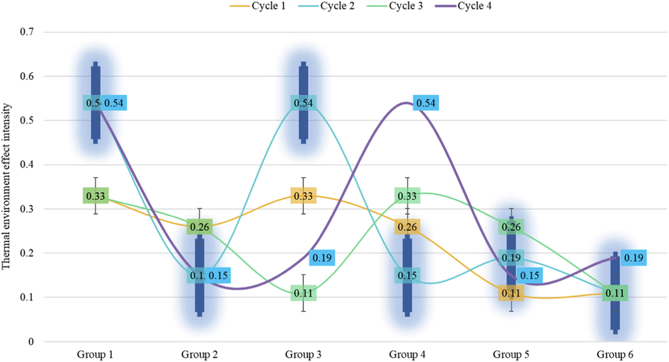
Eco-thermal environment effect intensity distribution.
In this water body restoration project, the new landscape composite vertical flow constructed wetland engineering technology is used to achieve the purification of lake water and reclaimed water quality, thereby improving the quality of the water delivered to the green space settlement landscape. After calculating the water treatment capacity of the green space settlement landscape constructed wetland treatment system, it is found that the system can handle circulating water.
4.4 Landscape model optimization
The form of the green space settlement landscape is similar to the semantic difference scale, but it is more concise and more targeted. Participants were asked to express their opinions on a set of statement sentences related to the measurement subject. A set of statement sentences was divided into 5 levels only, and the corresponding scores were 1–5 points. The recording of the scores further clarified the scale of each level. expression. Under normal circumstances, Table 2 has higher reliability than scales of the same length.
Measurement subject
Level 1
Level 2
Level 3
Level 4
Level 5
1
0.13729
0.53313
0.01689
0.55578
0.13729
2
0.26149
0.40064
0.24574
0.50713
0.26149
3
0.12235
0.59456
0.10238
0.01055
0.12235
In order to meet the flood control needs of the green space settlement landscape and the green space settlement landscape management, the project originally built six dams, but the original dams were only water conservancy facilities and lacked landscape. Therefore, in this design, some landscapes were created to create conditions to enhance their landscape and public participation. Some dams have a large drop, and secondary dams can be designed downstream of them to improve the viewing effect of falling water. On some dams with small drop and slow water flow, design hard facilities that allow people to walk water and walk, increase public participation and enhance the interest of the landscape.
The preliminary survey results of green space in residential areas show that there is a common phenomenon in residential green space that there are relatively single tree species and a small number. The species richness and diversity index of the arbor layer of the built residential green space is higher than that of the residential green space built in Fig. 4. Cinnamomum camphora have an absolute advantage in quantity, but in recent years, the types of street trees selected have begun to show a trend of diversification.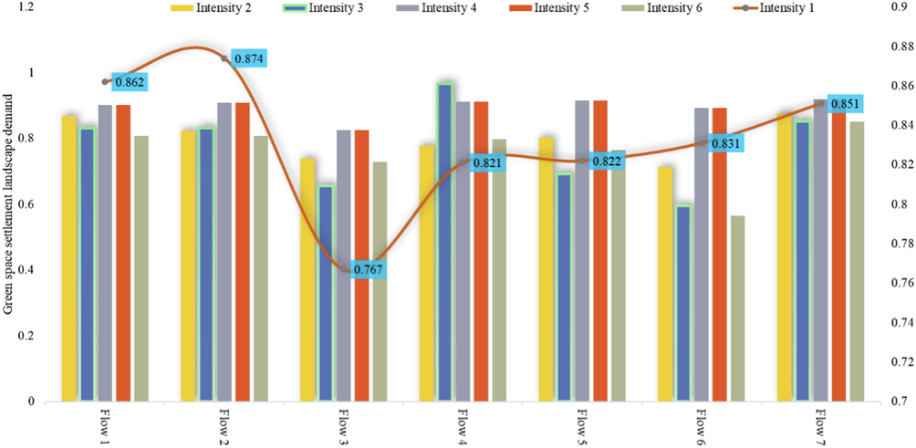
Distribution of landscape demand for green space settlements.
5 Application and analysis of green space settlement landscape optimization model
5.1 Ecological environment restoration data preprocessing
Such changes in the ecological environment are related to the distribution of point and non-point source pollution in the planned area. The content of total phosphorus and total nitrogen is mainly related to agricultural non-point source pollution. The small change of total phosphorus content indicates that the amount of total phosphorus entering the river is very small and basically does not exceed the environmental capacity; while the total nitrogen content shows an increasing trend, indicating that there is nitrogen runoff through the surface, which is also the main direction of our treatment of non-point source pollution.
Among them, the reclaimed water submerged wetland and the circulating water submerged wetland play a major role in water purification in the entire system and have distinct characteristics. The U-shaped groove principle completes the connection between the circulating water submerged wetland and the reclaimed water submerged wetland. The ascending pool of the entire system is the recirculating water underflow wetland in the east, and the descending pool is the reclaimed water underflowing wetland in the west. The up and down pools are used to filter and settle the supplementary water.
The descending pool and the ascending pool are composed of multiple packing beds of different thicknesses and different stone diameters, and an impermeable layer is set at the bottom of the bed. In Fig. 5, the supplementary water flows inside the wet underground packed bed. In the process of contact with plant roots and microorganisms, the multiple effects of physics, chemistry and biology are used to purify sewage.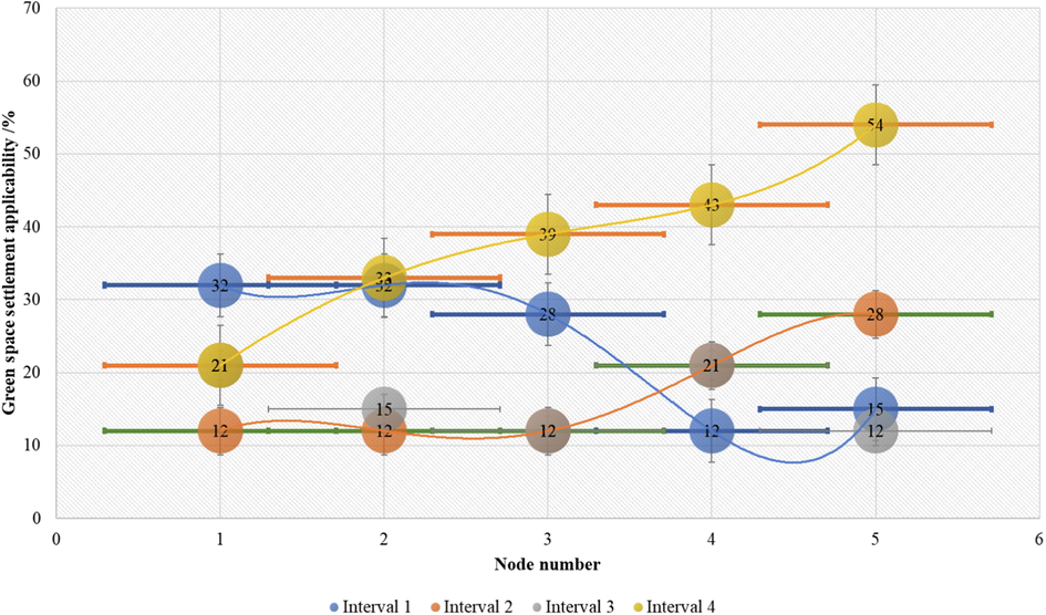
Distribution of suitability of green space settlements.
Restoring the natural curve of the green space settlement landscape is another key task for the vertical restoration of the green space settlement landscape. The green space settlement landscape with natural curves has rich and diverse habitats, such as shallows, deep pools, and plunges. These rich and diverse waterfront environments can provide habitats for a variety of animals and plants. The shoal is located at the junction of land and water, where the water flow slows down and it is easy to accumulate sediment and nutrients, so it becomes an important place for living creatures.
At the same time, it has the function of accumulating rainwater and increasing the elastic characteristics of the green space settlement landscape. The deep pool is mainly formed due to the erosion of the river bed by the falling water, and its depth is deeper than other areas, which can provide a good habitat for aquatic organisms, and due to the natural reoxygenation of the falling water, the oxygen content in the deep pool increases. There are more aerobic microorganisms than other areas, so it also has a certain purification effect on water bodies.
5.2 Simulation of settlement landscape optimization model
The noise evaluation of the settlement landscape is the evaluation of the impact of noise on people's psychology and physiology. Noise evaluation is based on the subjective perception of people, that is, the subjective evaluation of noise. Therefore, the objective physical quantity of noise sometimes cannot accurately reflect the subjective perception of noise.
It is necessary to compare some statistically correct evaluation quantities of subjective perception with the objective physical quantity of noise. In connection, this is also the main task of subjective noise evaluation. The subjective evaluation of noise is related to many disciplines such as acoustics, psychology, physiology, sociology, statistics, etc. Among the objective physical factors of acoustics, the sound pressure level is an important indicator of subjective evaluation.
The second indicator in Table 3 is the difference between the ground temperature (UHIp) within the outer ring line, the edge urban area outside the inner ring line (UHIp), and the suburban area (UHIR), expressed as UHIIP_R. It can be seen from the text that the built-up area within the outer ring shows a higher ground temperature than the suburban area, with a gradual decrease. The difference of R also shows a decreasing trend year by year.
Sensing values 1
Sensing values 2
Sensing values 3
Sensing values 4
Sensing values 5
Area 1
0.37593
0.06496
0.18595
0.25491
0.37593
Area 2
0.11983
0.56815
0.18126
0.24308
0.11983
Area 3
0.46531
0.06295
0.53818
0.46987
0.46531
Area 4
0.31067
0.43099
0.34569
0.38618
0.31067
Area 5
0.53158
0.0364
0.53928
0.15255
0.53158
According to remote sensing images and field surveys, the land vegetation mainly includes natural forests, sparse woodlands, artificial forests, shrubs, grasslands and arable land, orchards and other vegetation types. Natural forests are mainly distributed in the hilly area at the edge of the watershed. Sparse woodlands are generally distributed around some natural forests, but the forest coverage is lower than that of natural forests, with a canopy density of 10 %∼30 %.
Artificial forests are mainly distributed in the upper reaches of the eastern landscape of the sub-watershed. Near the village and on both sides of the green space settlement landscape, shrubs are mainly distributed in the hilly area around the natural forest, and mainly grow in the middle and lower parts of the mountain. Artificially cultivated vegetation mainly consists of crops and fruit trees. The western part of the basin is mostly farmland, with orchards scattered sporadically; in the east, farmland and orchards are staggered.
On the basis of following the overall pattern of green space settlement landscape, according to the particularity of topographical conditions, hydrological characteristics and surrounding land conditions and other relevant elements, the green space settlement landscape landscape will be studied in sections, according to the current characteristics and different needs of each region to determine the design direction of the landscape restoration of green space settlements, formulate restoration strategies according to local conditions.
5.3 Example application and analysis
Landscape rating methods include rating measurement method, paired comparison method, classification method, semantic difference scale method, participant sampling method, etc. In the rating measurement, Guildford believes that when the evaluator does not have extensive knowledge of the object being evaluated, the 5-level measure is the best to use, and the verbal description of feelings beyond the 5-level measure is a challenge. The numbers are easier to match with the verbal description.
Therefore, the fewer the number of segments in the measurement, the easier the verbal description is to understand. In addition, in the participant sampling method, with regard to the sample size, Daniel's research results show that the early results obtained from a small sample of 5–30 people have high internal consistency.
The purpose of landscape design is to create a sense of beauty on the basis of ensuring that it has complete functionality. Therefore, in the process of designing the landscape along the coast, full consideration was given to aesthetic principles. In the process of designing the waterfront landscape, such as the distribution and details of the square, we have fully considered and used aesthetic ideas. Fig. 6 analyzes from the overall perspective, making the urban landscape more beautiful, significantly improving the regional image, and establishing a unique landscape corridor.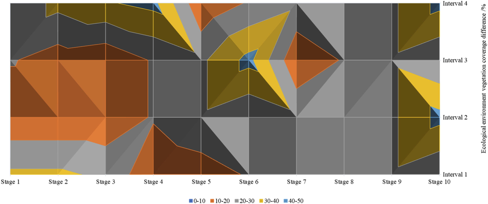
Distribution of the difference in vegetation coverage of the ecological environment.
The percentage of farmland in suburban areas has fallen by more than 50 %. Urban green space has an upward trend in core urban areas, but changes are complex in fringe urban areas and suburban areas. With the advancement of urbanization, the total vegetation coverage has fallen by more than 50 %.
Among them, the area of high and full vegetation coverage has dropped sharply, and the area of no, low and medium vegetation coverage has shown an upward trend. The transformation from urban green space to the external type is mainly the conversion to construction land, while the transformation within the green space type is mainly the transformation from farmland to urban green space.
According to the positioning and theme of each area of the green space settlement landscape, improve the detailed landscape design of greening, landscape sketches, green space settlement landscape infrastructure, etc., enrich the connotation and level of the green space settlement landscape, and create a diversified landscape node space.
In terms of greening design, according to the topographical environment and water level changes in the green space settlement landscape, rationally configure terrestrial and aquatic plants to create a rich waterfront plant community. While beautifying the green space settlement landscape, it also enhances the green space settlement.
The ecological benefits of the landscape enhance the self-purification capacity of the water body. In the design of the green space settlement landscape infrastructure, according to the different restoration strategies of each region, appropriate infrastructure is set up to meet its restoration needs. According to the green space settlement landscape and water conservancy factors, water-water facilities can be reasonably set up to meet people's water-water needs.
6 Conclusion
This article aims at the green space settlement landscape in northern cities with a small amount of ecological environment on weekdays and a short flood period, and creates green space settlement landscape spaces with different functions. For the first time, the division of sections of large, medium and small northern landscapes under the function of flood control and disaster reduction and the ecological restoration methods of each section are proposed. Secondly, using correlation analysis and regression analysis methods, the relationship model between the sound pressure level and the sound comfort level of the external traffic sound in the green space settlement landscape was established, and it was found that the ecological water body patch landscape factors all make the traffic sound comfort level increase with its sound pressure level. Based on the detailed analysis of the three ecological function models of the ecological environment effect evaluation model, the air pollutant removal model, the carbon storage and carbon absorption model, and the storm runoff reduction model. We explore the methods and ways to obtain the data required by the model, and under the guidance of the regional ecosystem analysis method, based on the urban green space evolution data, with the help of GIS technology to visualize its ecological value space. Finally, combined with the green space settlement landscape design of the urban section, the above research content was applied in practice. On the whole, within a certain range of sound pressure level, natural factors, landscape backgrounds, and landscapes with animals but no human activities have a strong effect on reducing the comfort of traffic sound.
Funding
Project No. 2021J047: 2021 Project of Shaanxi Social Science Foundation “Research on Public Art Intervention Path Based on Cultural Identity of Rural Space in Guanzhong Area” Project No. SJS2022ZD019): 2022 Teacher Education Reform and Development Research Project of Shaanxi Province “College Art Design Teachers” Scientific Research Feeds Teaching Practice and Exploration.
Declaration of Competing Interest
The authors declare that they have no known competing financial interests or personal relationships that could have appeared to influence the work reported in this paper.
References
- Designing optimal human-modified landscapes for forest biodiversity conservation[J] Ecol. Lett.. 2020;23(9):1404-1420.
- [Google Scholar]
- Where the wild things are! Do urban green spaces with greater avian biodiversity promote more positive emotions in humans?[J] Urban Ecosyst.. 2020;23(2):301-317.
- [Google Scholar]
- Exploring psychophysiological restoration and individual preference in the different environments based on virtual reality[J] Int. J. Environ. Res. Public Health. 2019;16(17):3102.
- [Google Scholar]
- The construction and optimization of ecological security pattern in the Harbin-Changchun urban agglomeration, China[J] Int. J. Environ. Res. Public Health. 2019;16(7):1190.
- [Google Scholar]
- Planning multifunctional green infrastructure for compact cities: what is the state of practice?[J] Ecol. Ind.. 2019;96:99-110.
- [Google Scholar]
- Assessment and optimization of green space for urban transformation in resources-based city–A case study of Lengshuijiang city, China[J] Urban For. Urban Green.. 2018;30:295-306.
- [Google Scholar]
- Exploring the impact of green space health on runoff reduction using NDVI[J] Urban For. Urban Green.. 2017;28:81-87.
- [Google Scholar]
- Environmental justice in the context of urban green space availability, accessibility, and attractiveness in postsocialist cities[J] Cities. 2020;106:102862
- [Google Scholar]
- Urban green space for health and well-being: developing an ‘affordances’ framework for planning and design[J] J. Urban Des.. 2017;22(6):778-795.
- [Google Scholar]
- Comprehensive performance evaluation of LID practices for the sponge city construction: a case study in Guangxi, China[J] J. Environ. Manage.. 2019;231:10-20.
- [Google Scholar]
- Quantitative analysis of the ecological security pattern for regional sustainable development: case study of Chaohu Basin in Eastern China[J] J. Urban Plann. Dev.. 2019;145(3):04019009.
- [Google Scholar]
- Attention restoration space on a university campus: exploring restorative campus design based on environmental preferences of students[J] Int. J. Environ. Res. Public Health. 2019;16(14):2629.
- [Google Scholar]
- Smarter ecosystems for smarter cities? a review of trends, technologies, and turning points for smart urban forestry[J] Sustain. Cities Soc.. 2019;51:101770
- [Google Scholar]
- Ecological connectivity networks in rapidly expanding cities[J] Heliyon. 2017;3(6):e00325.
- [Google Scholar]
- The impact of green space on violent crime in urban environments: an evidence synthesis[J] Int. J. Environ. Res. Public Health. 2019;16(24):5119.
- [Google Scholar]
- Optimizing the allocation of agri-environment measures to navigate the trade-offs between ecosystem services, biodiversity and agricultural production[J] Environ Sci Policy. 2018;84:186-196.
- [Google Scholar]
- Landscape ecological safety assessment and landscape pattern optimization in arid inland river basin: take Ganzhou District as an example[J] Hum. Ecol. Risk Assess. Int. J.. 2020;26(3):782-806.
- [Google Scholar]
- Green infrastructure: a planning concept for the urban transformation of former coal-mining cities[J] Int. J. Coal Sci. Technol.. 2018;5(1):78-91.
- [Google Scholar]
- Assessment of landscape ecological health: a case study of a mining city in a semi-arid steppe[J] Int. J. Environ. Res. Public Health. 2019;16(5):752.
- [Google Scholar]
- Impacts of large-scale open-pit coal base on the landscape ecological health of semi-arid grasslands[J] Remote Sens. (Basel). 2019;11(15):1820.
- [Google Scholar]
- Land use optimization based on ecosystem service assessment: a case study in the Yanhe watershed[J] Land Use Policy. 2018;72:303-312.
- [Google Scholar]
- Production scheduling optimization considering ecological costs for open pit metal mines[J] J. Clean. Prod.. 2018;180:210-221.
- [Google Scholar]
- How can urban blue-green space be planned for climate adaption in high-latitude cities? a seasonal perspective[J] Sustain. Cities Soc.. 2020;53:101932
- [Google Scholar]
- Research on evaluation index system of green highway in reconstruction and expansion projects[J] E3S Web Conf.. 2021;233:01136.
- [Google Scholar]
- Critical review on the cooling effect of urban blue-green space: a threshold-size perspective[J] Urban For. Urban Green.. 2020;49:126630
- [Google Scholar]


